
The Krishna River is a river in the Deccan plateau and is the third-longest river in India, after the Ganges and Godavari. It is also the fourth-largest in terms of water inflows and river basin area in India, after the Ganges, Indus and Godavari. The river, also called Krishnaveni, is 1,400 kilometres (870 mi) long and its length in Maharashtra is 282 kilometres. It is a major source of irrigation in the Indian states of Maharashtra, Karnataka, Telangana and Andhra Pradesh.

The Brahmaputra is a trans-boundary river which flows through Tibet (China), Northeastern India, and Bangladesh. It is known as Brahmaputra or Luit in Assamese,Yarlung Tsangpo in Tibetan, the Siang/Dihang River in Arunachali and Jamuna River in Bengali. It is the 9th largest river in the world by discharge, and the 15th longest.

The Mishmi people are an ethnic group of Tibet and Arunachal Pradesh, India. The area is known as the Mishmi Hills. Only one group, called the Deng, occupy Zayu County in southern Tibet. The Mishmis began to identity with the legendary Vaishnava characters created during this period which led to the formation of an alternate identity.
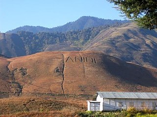
Anini is the headquarters of the Dibang Valley district in the state of Arunachal Pradesh in Northeast India. Anini was also the district headquarters of the undivided Dibang Valley district. Most of this location's population consists of the Idu Mishmi tribal people. Due to its remote location, Anini remains a small and underdeveloped town. However, it still has basic road and air links to the rest of India. The town is fully dependent on the nearest major settlement, Roing, which is in the Lower Dibang Valley District, for most commercial needs.
Tezu is a census town and the headquarters of Lohit district in the Indian state of Arunachal Pradesh. It is the fifth largest town in Arunachal Pradesh and one of its most developed.

The Lohit River, which name came from the Assamese word Lohit meaning blood, also known as the Zayul Chu by the Tibetans and Tellu by the Mishmis, is a river in China and India, which joins the Brahmaputra River in the state of Assam. It is formed in the Zayul County of the Tibet Autonomous Region, through a merger of two rivers: the Kangri Karpo Chu, which originates in the Kangri Karpo range, and Zayul Chu, which originates to its northeast. The two rivers merge below the town of Rima. The combined river descends through this mountainous region and surges through Arunachal Pradesh in India for 200 kilometres (120 mi) before entering the plains of Assam where it is known as the Lohit River. Tempestuous and turbulent, and known as the river of blood partly attributable to the lateritic soil, it flows through the Mishmi Hills, to meet the Siang (Brahmaputra) at the head of the Brahmaputra valley.

Roing is the district headquarter of Lower Dibang Valley district in the Indian state of Arunachal Pradesh. It is the last major township at the north-eastern frontier of India.
The Trans-Arunachal Highway (TAH), which includes an existing 1,811 km (1,125 mi) route comprising NH-13 and parts of NH-15, NH-215 and SH-25, is an under-construction 2-lane more than 2,407 km (1,496 mi) long highway passing through 16 districts in Arunachal Pradesh state in India. It runs from LAC in Tawang in northwest to Kanubari in southeast at tri-junction of Assam-Nagaland-Arunachal Pradesh. It connects at least 16 districts of Arunachal Pradesh.

The Polavaram Project is an under construction multi-purpose irrigation project on the Godavari River in the Eluru District and East Godavari District in Andhra Pradesh. The project has been accorded National project status by the Central Government of India. Its reservoir back water spreads up to the Dummugudem Anicut and approx 115 km on Sabari River side. Thus back water spreads into parts of Chhattisgarh and Odisha States. It gives major boost to tourism sector in Godavari Districts as the reservoir covers the famous Papikonda National Park, Polavaram hydro electric project (HEP) and National Waterway 4 are under construction on left side of the river. It is located 40 km to the upstream of Sir Arthur Cotton Barrage in Rajamahendravaram City and 25 km from Rajahmundry Airport.

The Mishmi Hills are located at the northeastern tip of India, in northeastern Arunachal Pradesh. On the Chinese side, they form the southern parts of Nyingchi Prefecture in the Tibet Autonomous Region.

The Bogibeel Bridge is a combined road and rail bridge over the Brahmaputra River in the northeastern Indian state of Assam between Dhemaji district and Dibrugarh district, which was started in the year 2002 and took a total of 200 months to complete, Bogibeel river bridge is the longest rail-cum-road bridge in India, measuring 4.94 kilometres over the Brahmaputra river. As it is situated in an earthquake-prone area it is India's first bridge to have fully welded steel-concrete support beams that can withstand earthquakes of magnitudes up to 7 on the Richter scale. It is Asia's second longest rail-cum-road bridge and has a serviceable period of around 120 years.

Dibang River, also known as Sikang by the Adi and Talo in Idu, is an upstream tributary river of the Brahmaputra in the Indian state of Arunachal Pradesh. It originates and flows through the Mishmi Hills in the (Upper) Dibang Valley and Lower Dibang Valley districts.
Arunachal Frontier Highway (AFH), officially notified as the National Highway NH-913 and also called Bomdila-Vijaynagar Highway (BVH), connecting Bomdila Airstrip ALG & HQ in northwest to Vijaynagar Airstrip ALG & HQ in southeast via Nafra HQ-Sarli HQ-Huri Helipad ALG & HQ-Nacho HQ-Mechuka Airstrip ALG & HQ-Monigong HQ-Jido -Hunli HQ-Hayuliang Airstrip ALG HQ-Chenquenty-Hawai HQ-Miao HQ including 800 km greenfield section and network of new tunnels & bridges, is a 2-lane paved-shoulder under-construction national highway along the India-China LAC-McMahon Line border in the Indian state of Arunachal Pradesh. The 1,748 km-long (1,086 mi) highway itself will cost ₹27,000 crore and total cost including 6 additional inter-corridors is ₹40,000 crore. In some places, this highway will run as close as 20 km from the LAC. To be constructed by MoRTH in 9 packages, all packages will be approved by the end of fy 2024-25 and construction will be completed in 2 years by 31 March 2027. Of the total route, 800km is greenfield, rest brownfield will be upgraded and tunnels will be built. This highway in the north & east Arunachal along the China border, would complement the Trans-Arunachal Highway and the Arunachal East-West Corridor as major highways spanning the whole state, pursuing the Look East connectivity policy.
East-West Industrial Corridor Highway of Arunachal Pradesh, a 2-lane and 966.78 km long including existing 274.20 km Pasighat-Manmao route, is a proposed highway across lower foothills of Arunachal Pradesh state in India from Bhairabkunda in Assam at tri-junction of Bhutan-Assam-Arunachal Pradesh in west to Kanubari tri-junction of Nagaland-Assam-Arunachal Pradesh in east.

National Highway 13, part of the larger Trans-Arunachal Highway network, is a 1,559 km long two-lane national highway across Arunachal Pradesh in India running from Tawang in northwest to Wakro in southeast. Entire route became operational in 2018 when 6.2 km long Dibang River Bridge was completed across Dibang River. Sela Tunnel, a shorter alternative route with target completion by Jan/Feb 2022, will provide all-weather connectivity. Before the renumbering of highways, it was known as NH 229 and NH52. This strategically important highway enhances Indian military's capabilities in combating the threat of China's Western Theater Command opposite India's eastern sector of Line of Actual Control.

The Dhola-Sadiya Bridge, officially known as Bhupen Hazarika Bridge, is a beam bridge in India, connecting the northeast states of Assam and Arunachal Pradesh. The bridge spans the Lohit River, a major tributary of the Brahmaputra, connecting the village of Dhola in the south to the village of Sadiya to the north, both in Tinsukia district of Assam, and providing convenient access to Arunachal Pradesh, whose border lies a short distance from Sadiya. The bridge is the first permanent road connection between the northern Assam and eastern Arunachal Pradesh.

Bhismaknagar is an archeological site in Indian state of Arunachal Pradesh. It is located near Roing in Lower Dibang Valley district. The remains are generally ascribed to the rule of the Sutiyas, a Bodo-Kachari (Tibeto-Burmese) ethnic group who ruled over the region of Sadiya from 11th to 16th Century CE.

The Dibang River Bridge is a beam bridge across Dibang River which connects Bomjir and Malek villages and provides all-weather connectivity between Dambuk and Roing in eastern part of Arunachal Pradesh, India. At 6.2 km long, it is the second-longest bridge above water in India and was completed in 2018 as part of NH13 Trans-Arunachal Highway. This strategically important bridge helps Indian military combat anti-national activities and Chinese military threat in the easter sector of Line of Actual Control border areas. It is known as "Sikang" in Adi Language and "Talon" in Idu Mishmi language.

The National Highways and Infrastructure Development Corporation Limited (NHIDCL) is a fully owned company of the Government of India, set up in 2014 and is responsible for management of a network of over 10,000 km of National Highways out of 1,15,000 km in India. It is a nodal agency of the Ministry of Road Transport and Highways. Chanchal Kumar (IAS) is the present Managing Director of NHIDCL since 31 January 2022.
