Nebraska Highway 13 is a highway in the northeastern part of the U.S. state of Nebraska that runs predominantly northwest-southeast with a south terminus east of Hadar at an intersection with U.S. Highway 81 and a north terminus two miles (3 km) south of Center, Nebraska at an intersection with Nebraska Highway 84.
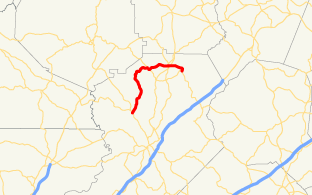
State Route 283 (SR 283) is a south-north state highway that runs in a wide arc in the northeastern part of the U.S. state of Georgia. Its route is located entirely within Hall County.

Nebraska Highway 4 is a highway in Nebraska. The entirety of the route is in Nebraska's southern tier of counties. Beatrice is the only city with over 1,000 in population on the highway. Its western terminus is at an intersection with US 6 and US 34 southwest of Atlanta. Its eastern terminus is at an intersection with US 75 north of Dawson.

Nebraska Highway 67 is a highway in southeastern Nebraska. Its southern terminus is at an intersection with U.S. Highway 73 near Verdon. Its northern terminus is at an intersection with U.S. Highway 34 near Nehawka. The segment between Nebraska Highway 2 and US 34 is one of four segments of road in the Nebraska highway system which is gravel.

Nebraska Highway 36 is a highway in Nebraska. Its western terminus is 0.17 miles (270 m) southwest of U.S. Highway 275 near Fremont, and its eastern terminus is at U.S. Highway 75 in Omaha.

Nebraska Highway 8 (N-8) is a highway in southern and southeastern Nebraska. Its western terminus is at Nebraska Highway 14 in Superior and its eastern terminus is at U.S. Highway 73 (US 73) in Falls City. It runs through the southern tier of counties in Nebraska and is always within 10 miles (16 km) of the Kansas border.

Nebraska Highway 9 is a highway in northeastern Nebraska. The southern terminus is located just north of West Point at an intersection with U.S. Highway 275. Its northern terminus is at an intersection with Nebraska Highway 12 just south of Ponca.

Nebraska Highway 109 is a highway in eastern Nebraska. Its southern terminus is at U.S. Highway 77 and Nebraska Highway 92 at Wahoo, Nebraska. Its northern terminus is at U.S. Highway 77 near Fremont, Nebraska.

Nebraska Highway 11 is a highway in central and northern Nebraska. Its southern terminus is at Interstate 80 south of Wood River. Its northern terminus is at the South Dakota border north of Butte. The highway goes through the eastern portion of the Sand Hills.

Nebraska Highway 12 is a highway in northern and northeastern Nebraska. It has a western terminus at U.S. Highway 83 in Valentine and an eastern terminus at U.S. Highway 20 west of Jackson. The highway largely lies within 10 miles (16 km) of the South Dakota border its entire length. The highway has been designated the Outlaw Trail Scenic Byway.
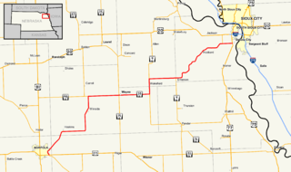
Nebraska Highway 35 is a highway in the northeastern part of the U.S. state of Nebraska. It has a western terminus in Norfolk at U.S. Highway 275 and Nebraska Highway 24 and an eastern terminus at U.S. Highway 77 and U.S. Highway 75 at Dakota City. The highway serves as a connector between Norfolk and Sioux City, Iowa.

Nebraska Highway 17 is a highway in southwestern Nebraska. It has a southern terminus at the Kansas border south of Culbertson and a northern terminus in Culbertson at an intersection with U.S. Highway 6 and U.S. Highway 34. The highway extends into Kansas at its southern terminus via K-117.

Nebraska Highway 21 is a highway in central Nebraska. Its southern terminus is at Nebraska Highway 23 east of Eustis. Its northern terminus is at an intersection with Nebraska Highway 2 and Nebraska Highway 92 in Broken Bow.
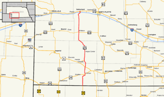
Nebraska Highway 25 is a highway in southwestern Nebraska. It runs for 87 miles (140 km). Its southern terminus is at the Kansas border south of Trenton. Its northern terminus is at U.S. Highway 30 in Sutherland.

Nebraska Highway 40 is a highway in central Nebraska. It has a length of 85.73 miles (137.97 km). It has a western terminus at Nebraska Highway 92 in Arnold and an eastern terminus north of Kearney at an intersection with Nebraska Highway 10.

Nebraska Highway 41 is a highway in Nebraska. It runs for a length of 103.53 miles (166.62 km) in a west-to-east direction. Its western terminus is in Clay Center at an intersection with Nebraska Highway 14 and Nebraska Spur 18D. Its eastern terminus is at an intersection with Nebraska Highway 50 north of Tecumseh.

Nebraska Highway 45 is a highway in Nebraska. It runs in a south-to-north direction for 27 miles (43 km). It has a southern terminus at Nebraska Highway 91 south of Newman Grove. It has a northern terminus in Tilden at an intersection with U.S. Highway 275.
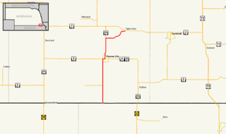
Nebraska Highway 65 is a highway in southeastern Nebraska. It is a north–south highway with a length of 15.25 miles (24.54 km). The southern terminus of Nebraska Highway 65 is at the Kansas border south of Pawnee City. The northern terminus is in Table Rock at an intersection with Nebraska Highway 4.

Nebraska Highway 69 is a highway in southeastern Nebraska. Its southern terminus is at an intersection with U.S. Highway 34 east of Waco. Its northern terminus is at an intersection with U.S. Highway 81 and Nebraska Highway 92 in Shelby.