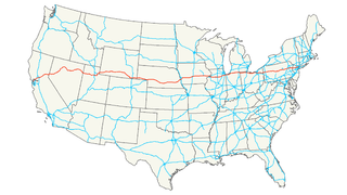
Interstate 29 (I-29) is an Interstate Highway in the Midwestern United States. I-29 runs from Kansas City, Missouri, at a junction with Interstate 35 and Interstate 70, to the Canada–US border near Pembina, North Dakota, where it connects with Manitoba Highway 75.
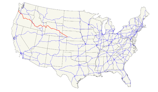
U.S. Route 26 is an east–west United States highway. It started in Ogallala, Nebraska, and was subsequently extended to the West Coast in Oregon. When the U.S. highway system was first defined, it was limited to Nebraska and Wyoming; by the 1950s, it continued into Idaho and Oregon. The highway's eastern terminus is in Ogallala, Nebraska at an intersection with Interstate 80. Its western terminus is south of Seaside, Oregon at an intersection with U.S. Route 101. Prior to 2004, the route's last 20 miles (32 km) were co-signed with U.S. Route 101 from the highways' junction south of Seaside north to Astoria where its intersection with U.S. Route 30 was also U.S. 30's western terminus.

U.S. Route 160 (US 160) is a 1,465 mile (2,358 km) long east–west United States highway in the Midwestern and Western United States. The western terminus of the route is at US 89 five miles (8 km) west of Tuba City, Arizona. The eastern terminus is at US 67 and Missouri 158 southwest of Poplar Bluff, Missouri.
U.S. Highway 138 (US 138), commissioned in 1926, is an east–west U.S. Highway in Colorado and Nebraska that travels predominantly northeast to southwest, paralleling the South Platte River and Interstate 76 (I-76). Like all spurs of the former US 66 and US 99, US 138 is an orphan route. US 38 was commissioned in 1926, but US 6 was extended over it to Long Beach, California. Therefore, US 138 still meets its former parent route's path.
U.S. Route 275 (US 275) is a north–south United States highway. It is a branch of US 75, originally terminating at that route in Council Bluffs, Iowa. The highway's northern terminus is in O'Neill, Nebraska, at an intersection with U.S. Highway 20 and U.S. Highway 281. Its southern terminus is near Rock Port, Missouri, at an intersection with U.S. Highway 136.

U.S. Route 34 (US 34) is an east–west United States highway that runs for 1,122 miles (1,806 km) from north-central Colorado to the western suburbs of Chicago. Through Rocky Mountain National Park it is known as the Trail Ridge Road where it reaches elevation 12,183 feet (3,713 m), making it the highest paved through highway in the United States. The highway's western terminus is Granby, Colorado at US 40. Its eastern terminus is in Berwyn, Illinois at Illinois Route 43 and Historic US 66.

U.S. Route 385 (US 385) is a spur of U.S. Route 85 that runs for 1,206 miles (1,941 km) from Deadwood, South Dakota to Big Bend National Park in Texas.
Interstate 76 (I-76) is an Interstate Highway that runs from Interstate 70 in Arvada, Colorado to an intersection with Interstate 80 near Big Springs, Nebraska. All but 3 miles of the road's route is in Colorado.

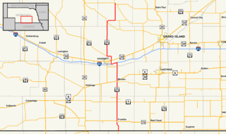
Nebraska Highway 2 is a highway in Nebraska. It is a discontinuous highway with 2 segments. The western segment begins at the South Dakota border northwest of Crawford and ends southeast of Grand Island at an intersection with Interstate 80. The eastern segment begins in Lincoln and ends at the Iowa border at Nebraska City. Previously, the two segments were connected via a route shared with U.S. Highway 34 between Grand Island and Lincoln.
Interstate 80 (I-80) in the U.S. state of Nebraska runs east from the Wyoming state border across the state to Omaha. When it completed construction of the stretch of I-80 spanning the state on October 19, 1974, Nebraska was the first state in the nation to complete its mainline Interstate Highway System.
Nebraska Highway 10 is a highway in Nebraska. Its southern terminus is at the Kansas border south of Franklin. Its northern terminus is at an intersection with Nebraska Highway 58, Nebraska Highway 92, and Recreation Road 82B in Loup City.

In the U.S. State of Nebraska, U.S. Highway 6 is a highway which goes from the Colorado border west of Imperial in the west to the Iowa border in the east at Omaha. Significant portions of the highway are concurrent with other highways, most significantly, U.S. Highway 34 between Culbertson and Hastings. Also, from Milford east to the Iowa border, the highway is closely paralleled by Interstate 80.

Nebraska Highway 15 is a highway in the U.S. state of Nebraska. It has a southern terminus at the Kansas border south of Fairbury and a northern terminus northeast of Maskell at the South Dakota border.
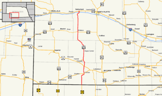
Nebraska Highway 25 is a highway in southwestern Nebraska. It runs for 87 miles (140 km). Its southern terminus is at the Kansas border south of Trenton. Its northern terminus is at U.S. Highway 30 in Sutherland.

Nebraska Highway 27 is a highway in Nebraska. It is divided into three segments. The southernmost segment begins at the Kansas border and goes north to Haigler. The middle segment begins at Interstate 80 near Chappell and goes north to Oshkosh. The northernmost segment begins at Ellsworth and goes north to the South Dakota border.

U.S. Highway 26 (US‑26) is an east–west highway in western Nebraska. It enters the state from Wyoming just west of Henry. The eastern terminus of US‑26 is in Ogallala at an interchange with Interstate 80 (Nebraska) (I-80). The highway largely parallels the North Platte River for the majority of its route in Nebraska and as such, runs at a northwest-southeast angle. The highway also parallels the original paths of the Oregon Trail, the California Trail and the Mormon Pioneer Trail.
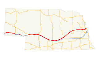
U.S. Highway 30 (US 30) is part of the United States Numbered Highway System that runs for 3,073 miles (4,946 km) from Astoria, Oregon to Atlantic City, New Jersey. Within the state of Nebraska it is a state highway that travels 451.74 miles (727.01 km) west to east across the state from the Wyoming state line west of Bushnell to the Missouri River in Blair on the Iowa state line. For much of its length it travels within the Platte River valley, adjacent or near the river between Brule and Fremont, a distance of just over 300 miles (480 km). This corridor was also highly traveled during Westward Expansion along the California and Oregon Trails, it was also used by the Pony Express and the Transcontinental Railroad. The landscape is dominated by vast agricultural fields within the fertile Platte River valley across the center of the state, while the western portion passes through higher plains and the eastern portion through the rolling hills adjacent to the Missouri River valley.

Nebraska Highway 71 is a highway in western Nebraska. Its southern terminus is at the Colorado border south of Kimball, as a continuation of Colorado State Highway 71. Its northern terminus is at the South Dakota border northwest of Crawford, where it continues as South Dakota Highway 71.

State Highway 71 (SH 71) is a 224-mile-long (360 km) state highway passing several other highways in northern and central Colorado. SH 71's southern terminus is at U.S. Route 350 near La Junta, and the northern terminus is a continuation as Nebraska Highway 71 (N-71) at the Nebraska border.
U.S. Route 385 (US 385) is a part of the United States Numbered Highway System that travels from Big Bend National Park in Texas to US 85 in Deadwood, South Dakota. Within the state of Nebraska, the highway is known as the Gold Rush Byway, one of nine scenic byways across the state. The highway follows along the old Sidney-Black Hills trail which played a crucial role during the Black Hills Gold Rush in the late 1870s. It served as the primary route to transport gold and mining gear between Sidney, Nebraska and the Black Hills to the north. Today, the highway enters Nebraska in the southeastern portion of the Nebraska Panhandle on the state line with Colorado northeast of Julesburg and continues in a northerly direction to the South Dakota state line north of Chadron.