
Nebraska Highway 50 (N-50) is a north–south highway in the state of Nebraska. The southern terminus is at the Nebraska-Kansas border near Du Bois. The northern terminus is in the Millard neighborhood of Omaha at an intersection with U.S. Highway 275 (US 275) and N-92. It is a two lane highway except for the section from Springfield north to the southern edge of the Millard neighborhood in Omaha, which is a divided highway.
K-1 is a 13.363-mile-long (21.506 km), north-south state highway in southern Comanche County, Kansas, United States, that connects Oklahoma State Highway 34 (SH‑34),with U.S. Route 160/U.S. Route 183 (US‑160/US‑183).

Nebraska Highway 4 is a highway in Nebraska. The entirety of the route is in Nebraska's southern tier of counties. Beatrice is the only city with over 1,000 in population on the highway. Its western terminus is at an intersection with US 6 and US 34 southwest of Atlanta. Its eastern terminus is at an intersection with US 75 north of Dawson.

Nebraska Highway 109 is a highway in eastern Nebraska. Its southern terminus is at U.S. Highway 77 and Nebraska Highway 92 at Wahoo, Nebraska. Its northern terminus is at U.S. Highway 77 near Fremont, Nebraska.

Nebraska Highway 99 is a highway in southeastern Nebraska. It has a southern terminus at the Kansas border south of Burchard and just north of Summerfield, Kansas. Its northern terminus is north of Burchard at an intersection with Nebraska Highway 4. It lies entirely in Pawnee County. It is a part of a three-state "Highway 99" which includes K-99 in Kansas and Oklahoma State Highway 99.

Nebraska Highway 85 is a highway in Nebraska. It is a highway in the Omaha Metro Area. It has a southern terminus at Nebraska Highway 370 in Papillion. Its northern terminus is at U.S. Highway 275 and Nebraska Highway 92 on the border of Omaha and Ralston. It is a four-lane highway for its entire length. Most people in the Omaha area think of the highway as part of 84th Street.

Nebraska Highway 14 (N-14) is a highway in the U.S. state of Nebraska. It has a southern terminus at the Kansas border, where it continues south as K-14, southwest of Superior and a northern terminus east of Niobrara at the South Dakota border.

Nebraska Highway 15 (N-15) is a highway in eastern Nebraska, United States. It has a southern terminus at the Kansas border south of Fairbury and a northern terminus northeast of Maskell at the South Dakota border.

Nebraska Highway 17 is a highway in southwestern Nebraska. It has a southern terminus at the Kansas border south of Culbertson and a northern terminus in Culbertson at an intersection with U.S. Highway 6 and U.S. Highway 34. The highway extends into Kansas at its southern terminus via K-117.

Nebraska Highway 23 is a 159.91-mile (257.35 km) highway in southwestern Nebraska, United States. Its western terminus is on the Colorado border at Venango, where the highway continues west as Colorado State Highway 23. Its eastern terminus is at Holdrege at an intersection with U.S. Highway 6 and U.S. Highway 34.
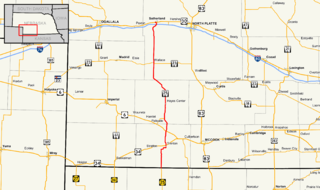
Nebraska Highway 25 is a highway in southwestern Nebraska. It runs for 87 miles (140 km). Its southern terminus is at the Kansas border south of Trenton. Its northern terminus is at U.S. Highway 30 in Sutherland.

Nebraska Highway 27 is a highway in Nebraska. It is divided into three segments. The southernmost segment begins at the Kansas border and goes north to Haigler. The middle segment begins at Interstate 80 near Chappell and goes north to Oshkosh. The northernmost segment begins at Ellsworth and goes north to the South Dakota border.

Nebraska Highway 45 is a highway in Nebraska. It runs in a south-to-north direction for 27 miles (43 km). It has a southern terminus at Nebraska Highway 91 south of Newman Grove. It has a northern terminus in Tilden at an intersection with U.S. Highway 275.
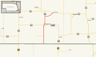
Nebraska Highway 53 is a highway in southern Nebraska. It is a north–south highway which runs for 12 miles (19 km). It has a southern terminus at U.S. 136 east of Gilead, and a northern terminus west of Daykin at Nebraska Highway 4.
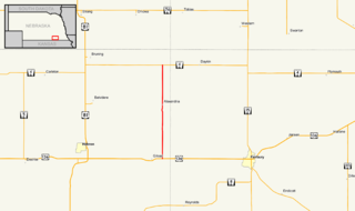
Nebraska Highway 65 is a highway in southeastern Nebraska. It is a north–south highway with a length of 15.25 miles (24.54 km). The southern terminus of Nebraska Highway 65 is at the Kansas border south of Pawnee City. The northern terminus is in Table Rock at an intersection with Nebraska Highway 4.

Nebraska Highway 61 is a highway in western Nebraska. It is a north–south highway with a length of 234.82 miles (377.91 km). The southern terminus of Nebraska Highway 61 is at the Kansas border south of Benkelman, where the highway continues south as K-161. The northern terminus is at the South Dakota border north of Merriman, where the highway continues north as South Dakota Highway 73.

Nebraska Highway 68 is a highway in central Nebraska. Its western terminus is at an intersection with Nebraska Highway 2 just south of Ravenna. Its eastern terminus is at an intersection with Nebraska Highway 58 in Rockville.
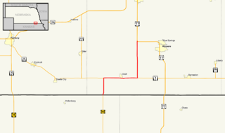
Nebraska Highway 112 is a highway in southeastern Nebraska. Its western terminus is at the Kansas border where it continues as K-148 southwest of Odell. Its eastern terminus is at U.S. Highway 77 west of Blue Springs.

Nebraska Highway 71 is a highway in western Nebraska. Its southern terminus is at the Colorado border south of Kimball, as a continuation of Colorado State Highway 71. Its northern terminus is at the South Dakota border northwest of Crawford, where it continues as South Dakota Highway 71.
K-161 is a 17-mile-long (27 km) north–south state highway located entirely within Cheyenne County in the U.S. State of Kansas. K-161's southern terminus is at U.S. Route 36 (US-36) in Bird City and the northern terminus is a continuation as Nebraska Highway 61 (N-61) at the Nebraska border. The entire length of K-161 is designated as the Ancient Indian Traders Trail.

