Nebraska Public Power District

Last updated
Nebraska Public Power District
Company typePublic corporation
IndustryPower generation
FoundedJanuary 1, 1971;53 years ago (January 1, 1971)
FounderGuy L. Myers
Headquarters,
United States
ProductsElectricity generation
OwnerState of Nebraska
Website nppd.com

Nebraska Public Power District (NPPD) is the largest electric utility in the state of Nebraska, serving all or parts of 84 (of 93) counties. [1] It was formed on January 1, 1970, when Consumers Public Power District, Platte Valley Public Power and Irrigation District (PVPPID) and Nebraska Public Power System merged to become Nebraska Public Power District. NPPD's predecessors were created through the efforts of the Nebraska legislature and financial agent Guy L. Myers as part of a system where all the investor-owned utilities operating in the state of Nebraska (Nebraska Power Co., Central Power Co., Southern Nebraska Power Co., et al.) were condemned and their properties turned over to 'public power districts' being created at the time (early 1940s). NPPD is a public corporation and political subdivision of the state of Nebraska. The utility is governed by an 11-member Board of Directors, who are popularly elected from NPPD's chartered territory.

Contents

NPPD's revenue is mainly derived from wholesale power supply agreements with 52 cities/villages and 25 rural public power districts and rural cooperatives. NPPD also serves about 79 communities directly at the retail level. Over 5,000 miles (8,000 km) of transmission lines make up the NPPD electrical grid system, which delivers power to about one million customers.

NPPD's corporate headquarters is located in Columbus, Nebraska.

Generating facilities

Nuclear

Cooper Nuclear Station Brownville

Cooper on June 15, 2011, during the 2011 Missouri River Floods Corp of Eng. 6-15-11 108.jpg
Cooper on June 15, 2011, during the 2011 Missouri River Floods

Coal

Gerald Gentleman Station Sutherland

Sheldon Power Station Hallam

Natural Gas

Canaday Station Lexington

Combined-cycle

Beatrice Power Station Beatrice

In addition, NPPD operates two wind generation facilities, nine hydroelectric facilities, nine diesel plants and three peaking units.

NPPD also purchases electricity from the Western Area Power Administration, which is operated by the United States Department of Energy.

Irrigation & Recreation

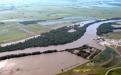
NPPD also operates the intricate network of irrigation canals, dams and reservoirs along a 150-mile (240 km) stretch of the Platte River which help power its hydro plants. In addition to the essential role the water plays in irrigating farmland and generating electricity in the area, the reservoir system provides fishing, hunting and boating opportunities for all Nebraskans.

Lake Maloney

Lake Maloney is located along Highway 83, five miles (8.0 km) south of the Interstate 80 exit at North Platte, Neb. Lake Maloney is used to regulate the flow of water for generating electricity at NPPD's nearby North Platte Hydro facility. The 1,650-acre (6.7 km2) reservoir is a popular place for fishing, skiing and boating. A handicap-accessible fishing pier, fish-cleaning station and 57 camping pads with electrical hookups are available at the lake's Inlet Recreation Area.

Lake Maloney's Outlet Recreation Area has camp sites, a trailer dump station, two boat ramp/docks, a fish-cleaning station and a shower house. Primitive camp sites are also available at several locations around the lake, and an 18-hole golf course is nearby. Entry to the lake requires a day or season pass from the Nebraska Game and Parks Commission. Camping fees are posted.

Lake Ogallala/Sutherland Supply Canal

Lake Ogallala and the Sutherland Supply Canal are among the top trout fisheries in the state. The area is also one of the best places in the nation for viewing a wide variety of native and migratory birds, including bald eagles.

The lake is formed by the Keystone Dam on the North Platte River. Canal roads can be accessed east from Highway 61 or north from U.S. 30 at Roscoe and Paxton. Because of steep banks and swift water, no wading, boating or watercraft are permitted in the canal. Anglers fishing from the banks are recommended to wear life jackets. Emergency buoys with ropes are location along the canal. This is a day-use area; no overnight camping is allowed.

Sutherland Reservoir

The Sutherland Reservoir is a 3,000-acre (12 km2) lake located three miles (4.8 km) south of the Interstate 80 Exit at Sutherland, Neb. NPPD owns and manages the Sutherland Reservoir, part of its hydropower system. Nebraska Game and Parks Commission (NGPC) oversees most of the recreation areas at the lake. A day or season pass is required for entry into NGPC areas.

Primitive campsites are located on the east and west sides of the lake, while a private camping area with electrical hook-ups and a nine-hole golf course are located along the north shore. Four boat launching ramps and two swimming areas are available. NPPD maintains a roost and perch tree protection program for eagles and, during the winter months, bird watchers can observe numerous wintering American Bald Eagles.

North Platte Trail

In North Platte, the city's riding and hiking path continues on the south side of town along NPPD's North Platte Hydro tailrace canal. Trail users travel under Interstate 80 on a low-water bridge along the canal. Hikers and bikers pass along the grass and gravel canal maintenance road to State Farm Road where the route continues west. From the bridge, trail users receive a fine view of the North Platte Hydro. Fishing is allowed north of the bridge, but not immediately downstream of the North Platte Hydro. Boaters and swimmers are restricted from the tailrace canal.

Kearney Canal Trail

Kearney Dam, Kearney, Nebraska, USA Kearney Dam, Kearney, Nebraska, USA.jpg
Kearney Dam, Kearney, Nebraska, USA

The City of Kearney and Buffalo County Parks and Recreation Department constructed an 8-foot (2.4 m)-wide concrete trail along NPPD's Kearney Canal in 1996. The 2.6-mile (4.2 km) scenic corridor is a gradual downhill grade from Cottonmill Park to the University of Nebraska at Kearney campus. The 16-mile (26 km)-long canal was built in the 1880s to divert Platte River water for irrigation and electrical generation. Cottonmill Lake once served as a reservoir for a cotton mill and now is a city park. The Kearney Dam & Hydro date to 1889. The 1.485-megawatt hydro-generator in the turret-looking tower was refurbished by NPPD in 1996. Access to NPPD's dam and hydro areas near the trail is restricted with no swimming or boating allowed.

Districts Served by NPPD

Wholesale Communities Served by NPPD

Retail Communities Served by NPPD

Related Research Articles

<span class="mw-page-title-main">South Platte River</span> River in Colorado and Nebraska, United States

The South Platte River is one of the two principal tributaries of the Platte River. Flowing through the U.S. states of Colorado and Nebraska, it is itself a major river of the American Midwest and the American Southwest/Mountain West. Its drainage basin includes much of the eastern flank of the Rocky Mountains in Colorado, much of the populated region known as the Colorado Front Range and Eastern Plains, and a portion of southeastern Wyoming in the vicinity of the city of Cheyenne. It joins the North Platte River in western Nebraska to form the Platte, which then flows across Nebraska to the Missouri. The river serves as the principal source of water for eastern Colorado. In its valley along the foothills in Colorado, it has permitted agriculture in an area of the Colorado Piedmont and Great Plains that is otherwise arid.

<span class="mw-page-title-main">Lincoln County, Nebraska</span> County in Nebraska, United States

Lincoln County is a county located in the U.S. state of Nebraska. As of the 2020 census, the population was 34,676. Its county seat is North Platte. Despite the county's name, the state capital city of Lincoln is not in or near Lincoln County.

<span class="mw-page-title-main">Columbus, Nebraska</span> City in and county seat of Platte County, Nebraska, United States

Columbus is a city in and the county seat of Platte County, in the state of Nebraska in the Midwestern United States. The population was 24,028 at the 2020 census, making it the 10th most populous city in Nebraska.

<span class="mw-page-title-main">Loup City, Nebraska</span> City in Sherman County, Nebraska, United States

Loup City is a city in and the county seat of Sherman County, Nebraska, United States. The population was 1,173 at the 2010 census. Loup City is close to the Middle Loup River, and about 5 miles (8.0 km) from Sherman Reservoir.

<span class="mw-page-title-main">North Platte River</span> River in the Western United States

The North Platte River is a major tributary of the Platte River and is approximately 716 miles (1,152 km) long, counting its many curves. In a straight line, it travels about 550 miles (890 km), along its course through the U.S. states of Colorado, Wyoming, and Nebraska.

<span class="mw-page-title-main">Loup River</span> River in Nebraska, United States

The Loup River is a tributary of the Platte River, approximately 68 miles (109 km) long, in central Nebraska in the United States. The river drains a sparsely populated rural agricultural area on the eastern edge of the Great Plains southeast of the Sandhills. The name of the river means "wolf" in French, named by early French trappers after the Skidi band of the Pawnee, whose name means "Wolf People," and who lived along its banks. The river and its tributaries, including the North Loup, Middle Loup, and South Loup, are known colloquially as "the Loups", comprising over 1800 mi (2900 km) of streams and draining approximately one-fifth of Nebraska.

<span class="mw-page-title-main">Keepit Dam</span> Dam in North West Slopes, New South Wales

Keepit Dam is a major gated mass concrete gravity dam with an earth fill abutment and a central gated concrete overflow crest and six radial gate spillways across the Namoi River upstream of its junction with the Peel River in the North West Slopes region of New South Wales, Australia. The dam's purpose includes flood mitigation, hydro-power, irrigation, water supply and conservation. The impounded reservoir is called Lake Keepit.

<span class="mw-page-title-main">Nebraska Game and Parks Commission</span> U.S. state government agency

The Nebraska Game and Parks Commission (NGPC) is the State of Nebraska's State agency charged with stewardship of the state's fish, wildlife, state park, and outdoor recreation resources. The agency is led by a governor-appointed member commission consisting of 9 commissioners which directs agency management. The commission is also charged with issuing of state hunting licenses, fishing licenses, and boat registrations. The agency also manages State Parks and recreation areas throughout the state. It conducts public education programs for hunting and boating safety. The agency is headquartered in Lincoln, Nebraska.

<span class="mw-page-title-main">Ross Lake National Recreation Area</span> Recreation area in Washington, United States

Ross Lake National Recreation Area is a US national recreation area in north central Washington just south of the Canada–US border. It is the most accessible part of the North Cascades National Park Complex which also includes North Cascades National Park and Lake Chelan National Recreation Area. Ross Lake NRA follows the Skagit River corridor from the Canada–US border to the western foothills of the Cascades. The NRA contains a portion of scenic Washington State Route 20, the North Cascades Highway, and includes three reservoirs: 12,000-acre (4,900 ha) Ross Lake, 910-acre (370 ha) Diablo Lake, and 210-acre (85 ha) Gorge Lake. These reservoirs make up the Skagit River Hydroelectric Project operated by Seattle City Light. Nestled in the "American Alps" the Ross Lake NRA bisects the north and south units of North Cascades National Park.

<span class="mw-page-title-main">Amistad Reservoir</span> Hydroelectric reservoir in Coahuila, Mexico

Amistad Reservoir is a reservoir on the Rio Grande at its confluence with the Devils River 12 miles (19 km) northwest of Del Rio, Texas. The lake is bounded by Val Verde County on the United States side of the international border and by the state of Coahuila on the Mexican side of the border; the American shoreline forms the Amistad National Recreation Area. The reservoir was formed in 1969 by the construction of Amistad Dam. The dam and lake are managed jointly by the governments of the United States and Mexico through the International Boundary and Water Commission. The name of the dam and lake is the Spanish word for "friendship". The reservoir is also known as Lake Amistad.

<span class="mw-page-title-main">New Melones Lake</span> Reservoir in California, USA

New Melones Lake is a reservoir on the Stanislaus River in the central Sierra Nevada foothills, within Calaveras County and Tuolumne County, California.

<span class="mw-page-title-main">Loup Canal</span>

The Loup Canal is a hydroelectric and irrigation canal located in eastern Nebraska, United States. The canal is owned and managed by Loup Power District, a public power electric utility.

<span class="mw-page-title-main">Gerald Gentleman Station</span> Nebraskas largest electricity generating plant

Gerald Gentleman Station is the largest electricity generating plant in Nebraska, USA. It is located at 41°04′51″N101°08′35″W, just south of Sutherland. The plant, owned and operated by Nebraska Public Power District (NPPD), consists of two coal-fired generating units launched into service in 1979 and 1982, which together have the capability to generate 1,365 megawatts of power.

<span class="mw-page-title-main">Platte River State Park</span> Park in Nebraska, USA

Platte River State Park is a public recreation area encompassing 453 acres (183 ha) on the southern bluffs of the Platte River two miles (3.2 km) west of Louisville, Nebraska. The state park has a relatively steep, rolling topography compared to the surrounding region, with much of it forested.

Lake McConaughy is a reservoir on the North Platte River. It is located 9 miles (14 km) north of Ogallala, Nebraska, United States, near U.S. Highway 26 and Nebraska Highway 61. The reservoir was named for Charles W. McConaughy, a grain merchant and mayor of Holdrege, Nebraska, one of the leading promoters of the project. Although he did not live to see the completion of the project, his leadership and perseverance eventually culminated in a public power and irrigation project that helped Nebraska become one of the nation's leading agricultural states.

<span class="mw-page-title-main">Merritt Dam</span>

Merritt Dam is a dam in Cherry County, Nebraska, southwest of Valentine, in the north-central part of the state. The 126-foot (38 m) earthen dam impounds the Snake River as it flows along the southern edge of the Samuel R. McKelvie National Forest in the Sandhills. It created Merritt Reservoir in 1964 as a project of the United States Bureau of Reclamation. The reservoir holds almost 75,000 acre⋅ft (93,000,000 m3), with about 44 miles (71 km) of sandy shoreline and 3,000 surface acres (1,200 ha) of water.

<span class="mw-page-title-main">Sherman Dam (Nebraska)</span> Earthen dam in the United States

Sherman Dam is an earthen dam near Loup City, in the central part of the state of Nebraska in the Midwestern United States. It was constructed in 1961 by the United States Bureau of Reclamation. It has a height of 134 feet (41 m) and a length of 1,912 feet (583 m) at its crest. It impounds Oak Creek. The dam was originally constructed for flood control and irrigation, but is now owned and operated by the local Farwell Irrigation District and the Loup Basin Reclamation District.

<span class="mw-page-title-main">Virginia Smith Dam</span> Dam in Nebraska, United States.

Virginia Smith Dam is a dam in Garfield County, Nebraska, about five miles northwest of Burwell.

<span class="mw-page-title-main">Lewis and Clark State Recreation Area (Nebraska)</span> Recreation area in Nebraska, United States

Lewis and Clark State Recreation Area (SRA) is an 864-acre (350 ha) State Recreation Area located on the southern shore of Lewis and Clark Lake, in northeastern Nebraska. The recreation area is located in Knox County, approximately 12 miles (19 km) northwest of Crofton. The recreation area is managed by the Nebraska Game and Parks Commission.

References

  1. "About Us". www.nppd.com. Retrieved 2022-03-21.