Neffs Cave

Last updated
Neffs Cave
Neff's Canyon Cave
Neffs canyon cave UT.jpg
Typical passage in Neffs Canyon Cave in Utah. The cave is developed along a single fissure passage with many loose rocks and dropoffs requiring rope for descent.
Location Salt Lake County, Utah
Coordinates 40°40′34″N111°46′30″W / 40.676161°N 111.775073°W / 40.676161; -111.775073
Depth1,163 ft (354 m)
Length1,700 ft (520 m)
Discovery1949
GeologyLimestone, Shale
Entrances1
DifficultyHard
HazardsRotten shale
AccessRestricted

Neffs Cave (or Neffs Canyon Cave) is a cave in Neffs Canyon on the north side of Mount Olympus, directly east of Millcreek, Utah in the United States. It is one of the deepest caves in the United States but is seldom entered despite its depth and its proximity to Salt Lake City. The United States Forest Service has closed the cave to the public for many years due to safety hazards. In 1977, Neffs Canyon Cave was designated as a National Natural Landmark by the National Park Service. [1]

Contents

Discovery and exploration

Neffs Cave was discovered in 1949 by two teenage brothers, John and Jamie Lyon, who were hiking in Neffs Canyon. [2] They returned to the cave several times to explore its depths but lacked the proper equipment to reach the bottom. In one of their last visits, John Lyon and a group of friends became trapped at the bottom of a steep slope of crumbly shale and had to be extracted by a rescue party, headed by his brother Jamie Lyon. [3] [4]

After the rescue, word about the cave began to spread. A party of inexperienced explorers reported that they went an estimated 2,000 feet (610 meters) into the cave and encountered a sheer drop of over 100 feet (30 meters) that prevented their further exploration. They wrote to the Wasatch National Forest staff, "Our advice is, keep out." Subsequently, in 1951 a team under the direction of the National Park Service explored the cave for several hours and reported that the cave had no scenic value and was too dangerous to be a National Park Service attraction. [3]

In 1952 the Salt Lake Grotto of the National Speleological Society was established, and several weeks later, the grotto's members obtained permission from the National Forest Service to explore the cave. They spent nearly eleven hours in the cave but had not reached the end of the main passage before they had to turn back. Teams from the grotto returned in 1953 and 1956, and on the last visit, they succeeded in reaching the bottom of the main passage. They calculated a vertical depth of 1,186 feet (361 meters), which was later revised to 1,163 feet (354 meters). [3] Neffs Cave is the 15th deepest cave discovered in the United States. [5]

Features and geology

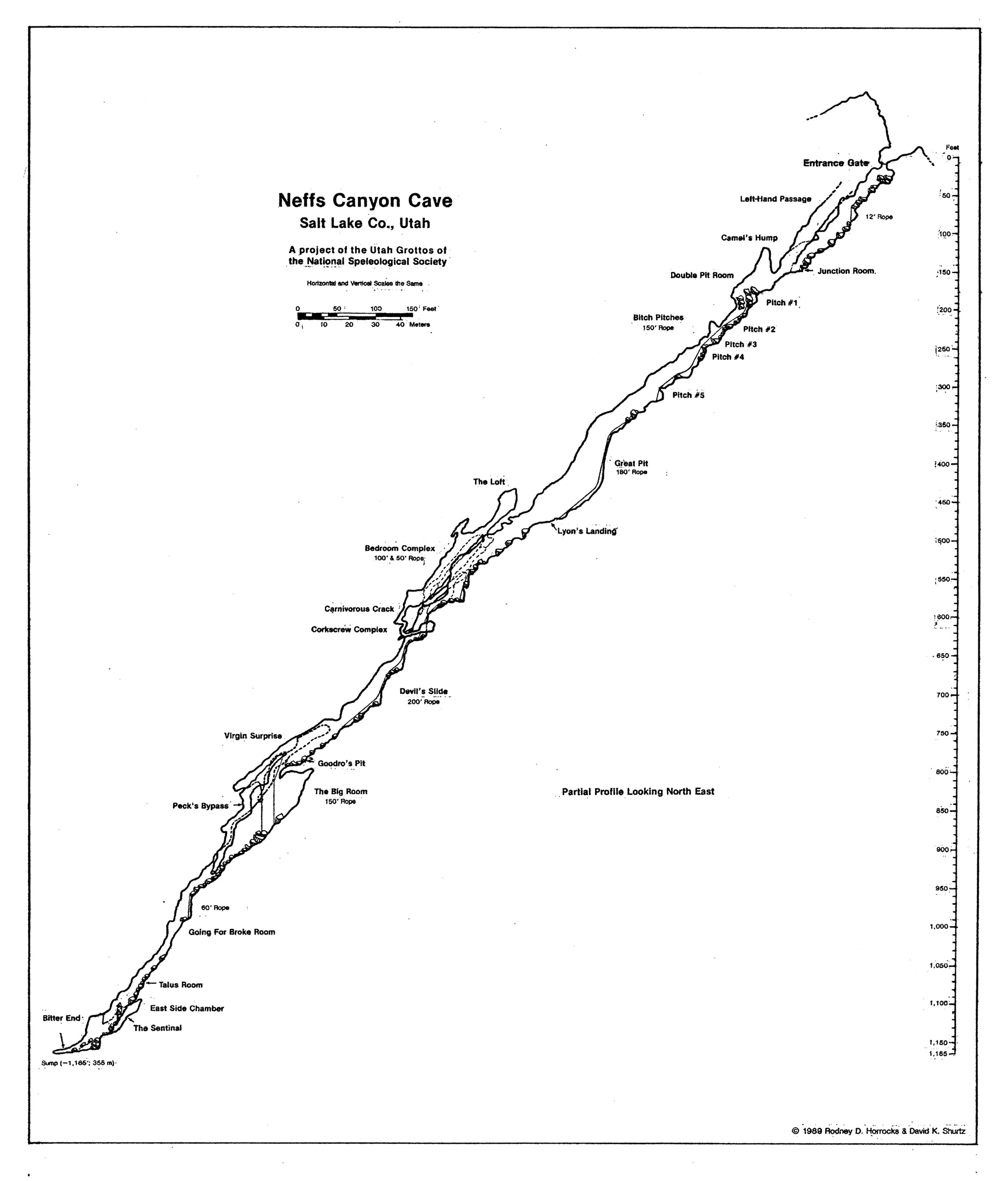
The cave entrance is a small, jagged opening in a gully at the base of low limestone cliffs. The main passage of the cave follows a deep fault in the limestone, dipping nearly due north. It descends through layers of limestone and shale, following a sink eroded by the gully stream. Side passages are rare except in an area called the Bedroom Complex, just past the halfway point of the main passage. [6] [7] [8]

Speleothems are uncommon in the cave. Cavers report areas of flowstone and a few stalactites. [3]

See also

Related Research Articles

<span class="mw-page-title-main">Sinkhole</span> Geologically-formed topological depression

A sinkhole is a depression or hole in the ground caused by some form of collapse of the surface layer. The term is sometimes used to refer to doline, enclosed depressions that are also known as shakeholes, and to openings where surface water enters into underground passages known as ponor, swallow hole or swallet. A cenote is a type of sinkhole that exposes groundwater underneath. Sink, and stream sink are more general terms for sites that drain surface water, possibly by infiltration into sediment or crumbled rock.

<span class="mw-page-title-main">Natural Bridge Caverns</span> United States historic place

The Natural Bridge Caverns are the largest commercial caverns in the US state of Texas. The name is derived from the 60-foot (18 m) natural limestone slab bridge that spans the amphitheater setting of the cavern's entrance. The span was left suspended when a sinkhole collapsed below it.

<span class="mw-page-title-main">Blanchard Springs Caverns</span>

Blanchard Springs Caverns is a cave system located in the Ozark–St. Francis National Forest in Stone County in northern Arkansas, USA, 2 miles (3.2 km) off Highway 14 a short distance north of Mountain View. It is the only tourist cave owned by the United States Forest Service and the only one owned by the federal government outside the National Park System. Blanchard Springs Caverns is a three-level cave system, all of which can be viewed on guided tours.

Krubera Cave is the second-deepest-known cave on Earth, after the Veryovkina Cave. It is located in the Arabika Massif of the Gagra Range of the Western Caucasus, in the Gagra District of Abkhazia, a partly recognised state, previously part of Soviet Georgia.

<span class="mw-page-title-main">Jewel Cave National Monument</span> Cave in the Black Hills of South Dakota, USA

Jewel Cave National Monument contains Jewel Cave, currently the fifth longest cave in the world and second longest cave in the United States, with 220.01 miles (354.07 km) of mapped passageways as of May 2024. It is located approximately 13 miles (21 km) west of the town of Custer in Black Hills of South Dakota. It became a national monument in 1908.

<span class="mw-page-title-main">Lechuguilla Cave</span> Cave in Eddy County, New Mexico, U.S.

At 150.4 miles (242.0 km), Lechuguilla Cave is the eighth-longest explored cave in the world and the second deepest in the continental United States. It is most famous for its unusual geology, rare formations, and pristine condition.

<span class="mw-page-title-main">Carlsbad Caverns National Park</span> National Park in New Mexico, United States

Carlsbad Caverns National Park is a national park of the United States in the Guadalupe Mountains of southeastern New Mexico. The primary attraction of the park is the show cave Carlsbad Cavern. Visitors to the cave can hike in on their own via the natural entrance or take an elevator from the visitor center.

<span class="mw-page-title-main">Germany Valley</span>

Germany Valley is a scenic upland valley high in the Allegheny Mountains of eastern West Virginia originally settled by German farmers in the mid-18th century. It is today a part of the Spruce Knob–Seneca Rocks National Recreation Area of the Monongahela National Forest, although much ownership of the Valley remains in private hands.

<span class="mw-page-title-main">Grand Caverns</span> Cave in Virginia, United States

Grand Caverns, formerly known as Weyer's Cave, is located in the central Shenandoah Valley in the town of Grottoes, Virginia, United States. A limestone cavern, it claims the distinction of being America's oldest show cave, in operation since 1806.

<span class="mw-page-title-main">Lost River (Indiana)</span> River in Indiana, United States

The Lost River is a river that rises in Vernon Township, Washington County, Indiana, and discharges into the East Fork of the White River in Lost River Township, Martin County, Indiana. The river's unusual hydrology has led to two of its features being named as National Natural Landmarks.

<span class="mw-page-title-main">Ricks Spring</span> Karst spring in Utah, USA

Ricks Spring is a karst spring, a natural water outflow from a cave in Logan Canyon within the Wasatch-Cache National Forest in northeast Utah. The spring is not an artesian source, but comes from the Logan River. Ricks Spring is the best known of several springs in an underground water network of the area.

<span class="mw-page-title-main">Škocjan Caves</span> Cave system in Slovenia

Škocjan Caves is a cave system located in Slovenia. Škocjan Caves was included on UNESCO’s list of natural and cultural World Heritage Sites in 1986. Škocjan Caves is a significant underground phenomenon on the Karst Plateau and in Slovenia. After gaining independence from Yugoslavia in 1991, Slovenia made a commitment to actively protect the Škocjan Caves area. To fulfill this commitment, Škocjan Caves Regional Park was established, along with its managing authority, the Škocjan Caves Park Public Service Agency.

Onyx Cave is a solutional cave system with about 0.5 miles (0.8 km) of passages formed in Permian limestone in the Santa Rita Mountains of Arizona. It is part of the Coronado National Forest. It was designated a National Natural Landmark in 1974.

<span class="mw-page-title-main">Short Drop Cave - Gavel Pot System</span> Cave entrances in Lancashire, England

Short Drop Cave and Gavel Pot are different entrances into the same cave system on Leck Fell, in Lancashire, England. The main top entrance, Short Drop Cave, is a small hole in a fenced-off shakehole near the main stream sink. Gavel Pot, a window into the system, is a large fenced shakehole some 40-metre (130 ft) deep requiring tackle to descend. There are two other smaller entrances into Short Drop Cave. At its base the system links via a sump with Lost Johns' Cave, and is part of the Three Counties System, an 87 kilometres (54 mi) cave system which spans the borders of Cumbria, Lancashire, and North Yorkshire.

<span class="mw-page-title-main">Tears of the Turtle Cave</span> Limestone cave in Montana

Tears of the Turtle Cave is located in the Bob Marshall Wilderness in western Montana and is currently the deepest known limestone cave in the United States since passing New Mexico's Lechuguilla cave in 2014. As of August 2024, the cave is known to be 2,477 feet (755 m) deep and 1.88 miles (3,030 m) long. The cave consists mostly of narrow fissure passages passing over approximately 50 short rope drops. The cave has a temperature of 37 °F (3 °C), and it is muddy and poorly decorated.

<span class="mw-page-title-main">Boybuloq</span> Cave in Uzbekistan

Boybuloq is a limestone cave in Uzbekistan, the deepest cave in Central Asia and all Asia except its western part. The cave is 1,517 metres (4,977 ft) deep and 18,400 metres (60,400 ft) long with the main entrance at an elevation of 2,647 metres (8,684 ft). It is situated at the edge of Baysun-Tau mountain ridge, the southern spur of the Gissar Range, in the southeast of the country. The nearest village is Dehibolo, to the northeast of Boysun.

<span class="mw-page-title-main">Ekaterinburg Speleo Club</span> Russian speleological organization

Ekaterinburg Speleo Club (SGS) (from Sverdlovskaja Gorodskaja Speleosekcija; Свердловская Городская Спелеосекция – СГС), founded in 1961, is a Russian, non-profit speleological organization dedicated to the exploration, research, and conservation of caves. It is based in Ekaterinburg (named Sverdlovsk from 1924 to 1991), the fourth largest city of Russia, in the Middle Urals and on the western edge of Siberia. SGS is most known for the exploration of caves in the northern Sverdlovsk Oblast and high-mountain karst areas of Surxondaryo Region in Uzbekistan, including Boybuloq, the deepest cave in Central Asia and one of the deepest caves in the world.

<span class="mw-page-title-main">Cave diving regions of the world</span> Regions of the world where known cave diving venues exist

Cave diving is underwater diving in water-filled caves. The equipment used varies depending on the circumstances, and ranges from breath hold to surface supplied, but almost all cave diving is done using scuba equipment, often in specialised configurations with redundancies such as sidemount or backmounted twinset. Recreational cave diving is generally considered to be a type of technical diving due to the lack of a free surface during large parts of the dive, and often involves planned decompression stops. A distinction is made by recreational diver training agencies between cave diving and cavern diving, where cavern diving is deemed to be diving in those parts of a cave where the exit to open water can be seen by natural light. An arbitrary distance limit to the open water surface may also be specified. Despite the risks, water-filled caves attract scuba divers, cavers, and speleologists due to their often unexplored nature, and present divers with a technical diving challenge.

<span class="mw-page-title-main">Morca Cave</span> Third-deepest cave in Turkey

The Morca Cave is located on the Taşeli plateau of the Taurus Mountains in the south of Turkey. Discovered in 1996, it had reached an explored depth of 1,276 meters and a length of 5,714 meters at the end of 2020. By then, Morca was Turkey's third deepest and eighth longest known cave. It has not been fully explored.

References

  1. "National Natural Landmarks - National Natural Landmarks (U.S. National Park Service)". www.nps.gov. Retrieved 2019-03-30. Year designated: 1977
  2. Lyon, John. "Neffs Cave." (Personal History, Salt Lake City Utah, in possession of the editor) Chapters 2-4.
  3. 1 2 3 4 Neffs Cave: America's Deepest Cave
  4. Buzzetti, John. "S.L. Youths Rescued from Cave." Salt Lake Telegram, 23 March 1950: 1-2. On-line.
  5. "USA DEEPEST (no Lava) CAVES Compiled by: Bob Gulden - August 21, 2022". www.caverbob.com. Archived from the original on May 15, 2006.{{cite web}}: CS1 maint: unfit URL (link)
  6. Neffs Cave - The "Timpanogos Grotto of the NSS" official website
  7. Overhead map of Neffs Cave
  8. Profile map of Neffs Cave