This article needs additional citations for verification .(December 2017) |

The Canadian city of North Bay, Ontario, is divided into numerous neighbourhoods.
This article needs additional citations for verification .(December 2017) |
The Canadian city of North Bay, Ontario, is divided into numerous neighbourhoods.
Birchaven1 is a neighbourhood located to the south of Trout Lake Road. Many people unfamiliar with this area and have incorrect maps mistakenly believe that it is called Birch Haven. Birchaven1 borders Trout Lake and extends to Wallace Road.
North Bay's Downtown is located along the shore of Lake Nipissing, between the Gateway and Ferris neighbourhoods. The area is aligned southeast to northwest, and bounded roughly by Fisher Street, Memorial Drive, Algonquin Avenue and Fifth Avenue.
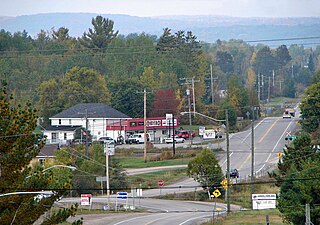
Feronia is a dispersed rural community and unincorporated place ( 46°21′44″N79°19′06″W / 46.36222°N 79.31833°W ). [1] It used to be a farming community with a school, general store and community centre. In 2005 Feronia is far less impressive, however still with a decent population scattered off the highway. There is still a community centre, which is mostly an ice rink and a swing set, and up off the highway slightly on Cemetery Road, you will find a cemetery that has been there since the early 1900s. Daly's Road, so named for the Daly family who had farms all along that road, Four Mile Lake Road and Feronia Road are predominantly the entrance points to Feronia off the highway.
Some time between 1906 and 1918, Maude Emma Beach became the first school teacher for the brand new one room school house built on Feronia Road. This school house serviced the farming community of the area, and it was not uncommon for children to miss school during harvest and planting time.
Gateway, one of the city's oldest residential neighbourhoods, is located immediately adjacent to the city's downtown core. The neighbourhood is centred on Algonquin Avenue.
Hornell Heights is the primary residential and institutional cluster on the grounds of CFB North Bay and Jack Garland Airport. Hornell Heights is not financially affiliated with the municipality of North Bay and is Federal land, funded and taken care of through Federal tax dollars. Currently North Bay provides transit service and snow removal service to some areas of Hornell Heights. Mail sent to this area is to be addressed to Hornell Heights, Ontario.
The Pinewood area, adjacent to Gateway, is roughly the area between Algonquin Avenue and Gormanville Road, Main West and Highway 17.
Thibeault Terrace is a residential neighbourhood located north of Highway 17 and west of the Algonquin Avenue segment of Highway 11. The neighbourhood is located between the escarpment and McKeown Avenue.
Thibeault Terrace is also the closest neighbourhood to the campuses of Canadore College and Nipissing University housing many students.
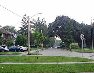
The residential neighbourhoods of St. John's Village, Eastview, Graniteville, Sage, Birchaven and Trout Mills extend northeasterly from the city core along Trout Lake Road.

West Ferris, formerly an independent township, was surveyed in 1880, and named after James Marshall Ferris, a member of the Legislative Assembly of Ontario. It was amalgamated into the city in 1968.
The township was quite small in size, sandwiched between the City of North Bay on the north, the township of North Himsworth on the south, East Ferris on the east, and Lake Nipissing on the west. The township consists of North Bay's southern suburbs, namely the community of West Ferris. The area also includes the neighbourhoods of Sunset Park, Marshall Park, Champlain Park, Thorncliff, Tweedsmuir and Nipissing Junction. The La Vase River bifurcates the township running from the east into Lake Nipissing, as does Highway 11 running north–south. The township is home to about 14,000 people.
Widdifield, formerly an independent township, was first surveyed in 1883 and named for Ontario MPP Joseph Henry Widdifield. It was amalgamated into the city in 1968, at the same time as West Ferris.
The pre-amalgamation boundary between North Bay and Widdifield extended along a line from Trout Lake to Lake Nipissing. The city's Lansdowne and Norwood Avenues, in the Gateway neighbourhood, marked part of the municipal boundary. The township also includes the smaller neighbourhoods of Cooks Mills, Feronia, Fricker, Hornell Heights, Lounsbury, Pinewood, Thibeault Terrace, Trout Mills, Wallace Heights, and Kenwood.
A neighbourhood in the northeastern corner of the city, near Widdifield Forest Provincial Park, retains the Widdifield name. Widdifield Secondary School was also the name of one of the city's main public high schools. The school closed in 2020.
The old Widdifield Fire Tower still stands on Tower Drive with its cupola removed. It is now used as a radio tower for the City of North Bay. In the winter of 1965 the tower was used in scenes from the old CBC TV show The Forest Rangers .

North Bay is a city in Northeastern Ontario, Canada. It is the seat of Nipissing District, and takes its name from its position on the shore of Lake Nipissing. North Bay developed as a railroad centre, and its airport was an important military location during the Cold War. The city is located 350 kilometres (220 mi) from both Ottawa and Toronto.

Etobicoke is an administrative district and former city within Toronto, Ontario, Canada. Comprising the city's west end, Etobicoke is bordered on the south by Lake Ontario, on the east by the Humber River, on the west by Etobicoke Creek, the cities of Brampton, and Mississauga, the Toronto Pearson International Airport, and on the north by the city of Vaughan at Steeles Avenue West.

Nipissing District is a district in Northeastern Ontario in the Canadian province of Ontario. It was created in 1858. The district seat is North Bay.
Mimico is a neighbourhood in Toronto, Ontario, Canada, being located in the south-west area of Toronto on Lake Ontario. It is in the south-east corner of the former Township of Etobicoke, and was an independent municipality from 1911 to 1967.

The Petawawa River is a river in the Saint Lawrence River drainage basin in Nipissing District and Renfrew County in eastern and northeastern Ontario, Canada. The river flows from Algonquin Provincial Park to the Ottawa River at the town of Petawawa, and is only one of two major tributaries of the Ottawa River to flow completely freely. The river's name comes from the Algonquian for "where one hears a noise like this", which refers to its many rapids.

The Barron River is a river in the Saint Lawrence River drainage basin in Nipissing District and Renfrew County, Ontario, Canada. It flows from Clemow Lake in northern Algonquin Provincial Park and joins the Petawawa River, whose southern branch it forms, in the municipality of Laurentian Hills, near the municipality of Petawawa.
Nipissing was a federal electoral district that was represented in the House of Commons of Canada from 1896 to 2004. It was located in the northeastern part of Ontario, Canada.
King's Highway 60, commonly referred to as Highway 60, is a provincially maintained highway in the Canadian province of Ontario. The 255.8-kilometre (158.9 mi) highway serves as the primary corridor through Algonquin Provincial Park, where it is dedicated as the Frank McDougall Parkway. East of Algonquin Park, the route serves east–west traffic in the highlands of central Ontario. It begins at Highway 11 in Huntsville and ends at Highway 17 near Renfrew.
East Ferris is a township in northeastern Ontario, Canada located between Trout Lake and Lake Nosbonsing in the District of Nipissing. West Ferris has long been annexed into the city of North Bay.

Nipissing is an incorporated (political) township in Parry Sound District in Central Ontario, Canada. It is on Lake Nipissing and is part of the Almaguin Highlands region. Nipissing was surveyed between 1874 and 1881, and was incorporated in 1888. Among the first settlers in the area were the Chapman and Beatty families. Nipissing Township annexed Gurd Township in 1970. The township also contains a community named Nipissing, which is located on the South River near Chapman's Landing, on the South Bay of Lake Nipissing. The township administrative offices are located in Nipissing.
South River is a village on Highway 124 near Algonquin Park in the Almaguin Highlands region of Parry Sound District of Ontario, Canada. It is about halfway between North Bay and Huntsville or a 3-hour drive (300 km) north from Toronto. South River has access to the Algonquin Park for canoeists at Kawawaymog. South River is home of Mikisew Provincial Park on the shores of Eagle Lake.

The Queensway–Humber Bay, known officially as Stonegate–Queensway, is a neighbourhood in the southwest of Toronto, Ontario, Canada. It is located in the southeast area of the former City of Etobicoke.
King's Highway 63, commonly referred to as Highway 63, is a provincially maintained highway in the Canadian province of Ontario. The 63.5-kilometre (39.5 mi) route travels from Highway 11 and Highway 17 in North Bay northeast to the Ontario-Quebec provincial boundary, where it continues as Route 101 into Témiscaming.

This is a list of neighbourhoods in the urban core of Greater Sudbury, Ontario. This list includes only those neighbourhoods that fall within the pre-2001 city limits of Sudbury — for communities within the former suburban municipalities, see the articles Capreol, Nickel Centre, Onaping Falls, Rayside-Balfour, Valley East and Walden.
The city of Timmins, Ontario, Canada contains many named neighbourhoods. Some former municipalities that were merged into Timmins continue to be treated as distinct postal and telephone exchanges from the city core.

Trout Lake is a lake in the municipalities of East Ferris and North Bay, Nipissing District, Northeastern Ontario, Canada. It lies approximately 6 kilometres (4 mi) east of the much larger Lake Nipissing, with the city of North Bay in between them. Trout Lake is the source of the Mattawa River and a significant body of water on a well-known historic North American voyageur (fur-trading) route. It is about 11 kilometres (7 mi) long and 4 kilometres (2 mi) wide and exits eastward into the Mattawa River, which flows via the Ottawa River to the St. Lawrence River. Some of the most difficult portages are found on this part of the voyageur route between Trout Lake and the end of the Mattawa River, e.g., Portage de Mauvaise Musique, located at the Talon Chute.

The Almaguin Highlands Region in Ontario, Canada, covers approximately 5,200 km2 (2,000 sq mi) comprising the eastern half of Parry Sound District. It is bounded by Muskoka in the south, and by Lake Nipissing and Nipissing District in the north. The eastern edge abuts the western boundary of Algonquin Provincial Park, whereas the western boundary of the Almaguin Highlands is generally regarded to be the mid east-west point of Parry Sound District. Originally derived from the words Algonquin, Magnetawan, and Seguin. the name Almaguin is now used to describe the marketing region of East Parry Sound.