Nekkallu

Last updated
Nekkallu
Neighbourhood
Location map India Andhra Pradesh EN.svg
Red pog.svg
Nekkallu
Location in Andhra Pradesh, India
Coordinates: 16°29′27″N80°26′24″E / 16.4907°N 80.4400°E / 16.4907; 80.4400 Coordinates: 16°29′27″N80°26′24″E / 16.4907°N 80.4400°E / 16.4907; 80.4400
Country India
State Andhra Pradesh
District Guntur
Mandal Thullur
Population (2011)
  Total 1,908
Languages
  Official Telugu
Time zone IST (UTC+5:30)
PIN 522 236
Telephone code +91–8645
Vehicle registration AP-07

Nekkallu is a neighbourhood and a part of Urban Notified Area of Amaravati, the state capital of the Indian state of Andhra Pradesh. [1] It was a village in Thullur mandal of in Guntur district, prior to its denotification as gram panchayat. [2] [3]

Neighbourhood geographically localized community within a larger city, town, suburb or rural area

A neighbourhood, or neighborhood, is a geographically localised community within a larger city, town, suburb or rural area. Neighbourhoods are often social communities with considerable face-to-face interaction among members. Researchers have not agreed on an exact definition, but the following may serve as a starting point: "Neighbourhood is generally defined spatially as a specific geographic area and functionally as a set of social networks. Neighbourhoods, then, are the spatial units in which face-to-face social interactions occur—the personal settings and situations where residents seek to realise common values, socialise youth, and maintain effective social control."

Andhra Pradesh State in southern India

Andhra Pradesh is one of the 29 states of India. Situated in the south-east of the country, it is the seventh-largest state in India, covering an area of 162,970 km2 (62,920 sq mi). As per the 2011 census, it is the tenth-most populous state, with 49,386,799 inhabitants. The largest city in Andhra Pradesh is Visakhapatnam. Telugu, one of the classical languages of India, is the major and official language of Andhra Pradesh.

Thullur mandal Mandal in Andhra Pradesh, India

Thullur mandal is one of the 57 mandals in Guntur district of the Indian state of Andhra Pradesh. It is under the administration of Guntur Revenue Division and the headquarters are located at Thullur. The mandal is situated on the banks of Krishna River, bounded by Amaravathi, Tadikonda, Tadepalle and Mangalagiri mandals. The mandal is also a part of the new capital city of Andhra Pradesh to be developed. 18 villages from the mandal fall under the jurisdiction of Andhra Pradesh Capital City.

Contents

Demographics

As of 2011 Census of India, the village had a population of 1,908, of which males are 936, females are 972 with sex ratio 1038. The population under 6 years of age are 224. The average literacy rate stands at 61.70%. [2]

The decennial Census of India has been conducted 15 times, as of 2011. While it has been undertaken every 10 years, beginning in 1872, the first complete census was taken in 1881. Post 1949, it has been conducted by the Registrar General and Census Commissioner of India under the Ministry of Home Affairs, Government of India. All the censuses since 1951 were conducted under the 1948 Census of India Act. The last census was held in 2011. The next will be held in 2021.

Transport

Nekkallu is located on the Amaravathi and Mangalagiri route. APSRTC run buses provide transport services from Amaravathi and Mangalagiri to Nekkallu.

Mangalagiri Town in Andhra Pradesh, India

Mangalagiri is a town in Guntur district situated between the twin cities of Vijayawada and Guntur of the Indian state of Andhra Pradesh. The town is the headquarters of Mangalagiri mandal under Guntur revenue division. It is a major suburb of the cities of Vijayawada and Guntur. It also forms a part of the Andhra Pradesh Capital Region. It is situated on National Highway 16 between Vijayawada and Guntur. The town was known to have existed since 225 B.C.. It is also a part of Andhra Pradesh Capital Region with a population of 73,613.

Related Research Articles

Amaravathi (village), Andhra Pradesh Village in Andhra Pradesh, India

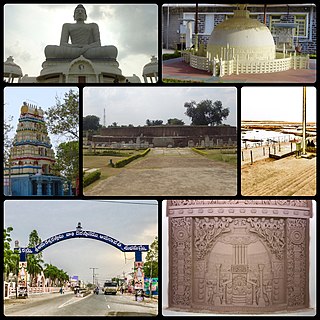
Amaravathi is a village in Guntur district of the Indian state of Andhra Pradesh. It is located on the banks of Krishna River in Amaravathi mandal of Guntur revenue division. The village is a part of Andhra Pradesh Capital Region, located 35 km (22 mi) west of the foundation stone of Amaravathi laid at Uddandarayunipalem. Amaravati, the capital of Andhra Pradesh derives its name from the village. It is a heritage town and was the capital of the Satavahana Kingdom. Amaralingeswara temple in the village is a Pancharama Kshetra for the Hindus. It is also a historic Buddhist site, and the Amaravathi Mahachaitya stupa was built here between the 2nd century BCE and the 3rd century CE. There is also the Dhyana Buddha statue, a very large 21st-century Buddha statue in Dhyana posture. It is one of the sites for Heritage City Development and Augmentation Yojana (HRIDAY) scheme of Government of India.

Dharanikota Village in Andhra Pradesh, India

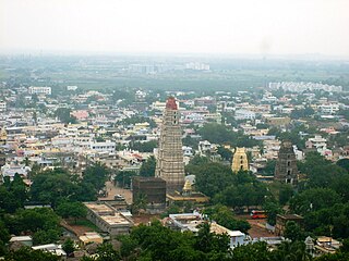
Dharanikota is a village in Guntur district of the Indian state of Andhra Pradesh. It is located in Amaravati mandal of Guntur revenue division.

Rayapudi Neighbourhood in Guntur, Andhra Pradesh, India

Rayapudi is a neighbourhood and a part of Urban Notified Area of Amaravati, the state capital of the Indian state of Andhra Pradesh. It was a village in Thullur mandal of in Guntur district, prior to its denotification as gram panchayat.

Venkatapalem Neighbourhood in Guntur, Andhra Pradesh, India

Venkatapalem is a neighbourhood and a part of Urban Notified Area of Amaravati, the state capital of the Indian state of Andhra Pradesh. It was a village in Thullur mandal of Guntur district, prior to its denotification as gram panchayat.

Ananthavaram Neighbourhood in Coastal Andhra, Andhra Pradesh, India

Anantavaram is a neighbourhood and a part of Urban Notified Area of Amaravati, the state capital of the Indian state of Andhra Pradesh. It was a village in Thullur mandal of Guntur district, prior to its denotification as gram panchayat.

Dondapadu Neighbourhood in Krishna, Andhra Pradesh, India

Dondapadu is a neighbourhood and a part of Urban Notified Area of Amaravati, the state capital of the Indian state of Andhra Pradesh. It was a village in Thullur mandal of Guntur district, prior to its denotification as gram panchayat.

Amaravati City in Andhra Pradesh, India

Amaravati is the de facto capital city of the Indian state of Andhra Pradesh. The planned city is located on the southern banks of the Krishna river in Guntur district, within the Andhra Pradesh Capital Region, being built on a 217 sq km riverfront designed to have 51% of green spaces and 10% of water bodies. The word "Amaravati" derives from the historical Amaravathi village, the ancient capital of the Satavahana dynasty. The foundation stone was laid on 22 October 2015, at Uddandarayunipalem area by the Prime Minister, Narendra Modi. The metropolitan area of Guntur and Vijayawada are the major conurbations of Amaravati.

Velagapudi Neighbourhood in Guntur, Andhra Pradesh, India

Velagapudi is a neighbourhood and a part of the Urban Notified Area of Amaravati, the state capital of the Indian state of Andhra Pradesh. It was a village in Thullur mandal of Guntur district, prior to its denotification as gram panchayat. Velagapudi is also the home to the temporary Secretariat of Andhra Pradesh

Krishnayapalem Neighbourhood in Guntur, Andhra Pradesh, India

Krishnayapalem is a neighbourhood and a part of Urban Notified Area of Amaravati, the state capital of the Indian state of Andhra Pradesh. It was a village in Mangalagiri mandal of Guntur district, prior to its denotification as gram panchayat.

Borupalem Neighbourhood in Guntur, Andhra Pradesh, India

Borupalem is a neighbourhood and a part of Urban Notified Area of Amaravati, the state capital of the Indian state of Andhra Pradesh. It was a village in Thullur mandal of in Guntur district, prior to its denotification as gram panchayat.

Penumaka Neighbourhood in Guntur, Andhra Pradesh, India

Penumaka is a neighbourhood and a part of Urban Notified Area of Amaravati, the state capital of the Indian state of Andhra Pradesh. It was a village in Tadepalle mandal of Guntur district, prior to its denotification as gram panchayat.

Pedda Madduru Village in Andhra Pradesh, India

Pedamadduru is a village in Guntur district of the Indian state of Andhra Pradesh. It is located in Amaravati mandal of Guntur revenue division..Agriculture is the main occupation of the people living in this village. The surnames of the people belongs to this village are mostly Podile,Jasti,Kilaru,Prathipati,Ginjupalli and some other surnames also.

Nowlur Neighbourhood in Guntur, Andhra Pradesh, India

Nowlur is a neighbourhood and a part of Urban Notified Area of Amaravati, the state capital of the Indian state of Andhra Pradesh. It was an out growth of Mangalagiri Municipality in Guntur district, prior to its merger in the urban area of the state capital.

Lingayapalem Neighbourhood in Guntur, Andhra Pradesh, India

Lingayapalem is a neighbourhood and a part of Urban Notified Area of Amaravati, the state capital of the Indian state of Andhra Pradesh. It was a village in Thullur mandal of in Guntur district, prior to its denotification as gram panchayat.

Nelapadu, Amaravati Neighbourhood in Guntur, Andhra Pradesh, India

Nelapadu is a neighbourhood and a part of Urban Notified Area of Amaravati, the state capital of the Indian state of Andhra Pradesh. It was a village in Thullur mandal of in Guntur district, prior to its denotification as gram panchayat.

Abbarajupalem, Amaravati (state capital) Neighbourhood in Guntur, Andhra Pradesh, India

Abbarajupalem is a neighbourhood and a part of Urban Notified Area of Amaravati, the state capital of the Indian state of Andhra Pradesh. It was a village in Thullur mandal of in Guntur district, prior to its denotification as gram panchayat.

Sakhamuru Neighbourhood in Guntur, Andhra Pradesh, India

Sakhamuru is a neighbourhood and a part of Urban Notified Area of Amaravati, the state capital of the Indian state of Andhra Pradesh. It was a village in Thullur mandal of in Guntur district, prior to its denotification as gram panchayat.

References

  1. "New Andhra capital Amaravati to compete for Smart City tag". The New Indian Express. 25 May 2016. Retrieved 6 June 2016.
  2. 1 2
  3. "Declaration of A.P. Capital City Area–Revised orders" (PDF). Andhra Nation. Municipal Administration and Urban Development Department. 22 September 2015. Archived from the original (PDF) on 24 June 2016. Retrieved 21 February 2016.