Neravy

Last updated

Neravy

Nérevy
Town
India location map.svg
Red pog.svg
Neravy
Location in India
Coordinates: 10°53′33″N79°48′57″E / 10.8926°N 79.8157°E / 10.8926; 79.8157 Coordinates: 10°53′33″N79°48′57″E / 10.8926°N 79.8157°E / 10.8926; 79.8157
CountryFlag of India.svg  India
State Puducherry
District Karaikal
Population
  Total10,890
Languages
  Official French, Tamil, English
Time zone UTC+5:30 (IST)

Neravy, or Neravi, is a town and commune in the Karaikal District of Puducherry, India.

Contents

The village lies 145 km south of Puducherry in the Puducherry district, and is located between Karaikal and Nagapattinam. It is made up of two detached areas separated by Nannilam Taluk of the Thanjavur District, next to the Tirunallar commune, with the easterly flow of the Arasalar River forming the commune boundary.

Three small isolated enclaves of Thanjavur District are embedded within the detached enclave of the Neravy commune.

Demographics

The total population of the Neravy commune according to the 2001 census is 10890. Of this, zero citizens are scheduled tribes (STs) and 2637 are scheduled caste (SC). The gender ratio of the population in Neravy is 1020 females per 1000 males. The literacy rate in the city is 81.19 per cent, 89.42 for males and 73.21 for females. [1]

A government school Husainia school,Neravy.jpg
A government school
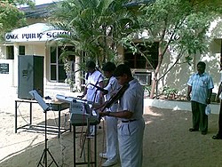
ONGC public school ONGC public school.jpg
ONGC public school
Husainia school,Neravy.jpg
Karaikal Beach People walking on the beach in Karaikal !!.jpg
Karaikal Beach


Related Research Articles

Puducherry (union territory) Union territory of India

Puducherry, also known as Pondicherry, is one of the 8 union territories of India. It was formed out of four territories of former French India, namely Pondichéry, Karikal (Karaikal), Mahé and Yanaon (Yanam), excluding Chandannagar. It is named after the largest district, Puducherry. Historically known as Pondicherry, the territory changed its official name to Puducherry on 20 September 2006.

Karaikal Town in Puducherry, India

Karaikal is a town of the Indian Union Territory of Puducherry. Karaikal became a French Colony in 1674 and held control, with occasional interruption from the British and Dutch, until 1954, when it was incorporated into the Republic of India, along with Chandernagore, Mahé, Yanaon, and Pondichéry.

Puducherry district District of Puducherry in India

The Puducherry district, also known by its former name Pondicherry district, is one of the four districts of the union territory of Puducherry in South India. The district occupies an area of 290 square kilometres (110 sq mi), spread over 11 non-contiguous enclaves lying on or near the Bay of Bengal within a compact area in the state of Tamil Nadu. According to the 2011 census, the district has a population of 950,289.

Puducherry Legislative Assembly Unicameral legislature of the Indian union territory of Puducherry

The Puducherry Legislative Assembly is the unicameral legislature of the Indian union territory (UT) of Puducherry, which comprises four districts: Puducherry, Karaikal, Mahé and Yanam. The legislative assembly has 33 seats, of which 5 are reserved for candidates from scheduled castes and 3 members are nominated by the Government of India. 30 out of 33 Members are elected directly by the people on the basis of universal adult franchise.

Karaikal district District of Puducherry in India

Karaikal district is one of the four districts of the Union Territory of Puducherry in India.

History of Puducherry

The City of Puducherry on the southeast coast of India does not have a recorded history from antiquity. Puducherry has history recorded only after the advent of the colonial powers such as the Dutch, Portuguese, English and the French. Nearby places such as Arikanmedu, Kakayanthoppe, Villianur, and Bahur, which were annexed by the French East India Company over a period of time and became the Union Territory of Puducherry after Independence, have written histories that predate the colonial era.

Arasalar River River in India

The river Arasalar is a river that flows through Tamil Nadu and Pudducherry, and a tributary of Kaveri river which splits into 5 different rivers when it enters into Thanjavur district from Trichy. It separates from river Kaveri in the place near Pullambadi where the Kaveri is stopped by Lower Anaicut and from Thiruvaiyaru. The river is one of the seven rivers runns in the Karaikal region of Puducherry. Findings of Central Pollution Control Board had revealed that the river is polluted by high concentrations of nitrate and chromium due to mixing of sewage water into the river stream and industrial activities in 2013.

Tiruvarur district District in Tamil Nadu, India

Thiruvarur district is one of the 38 districts in the Tamil Nadu state of India. As of 2011, the district had a population of 1,264,277 with a sex-ratio of 1,017 females for every 1,000 males.

ONGC Public School is located at Neravy in the Karaikal district of Puducherry union territory in India.

Adirampattinam Town in Tamil Nadu, India

Adirampattinam, also known by short Adirai, is a panchayat town in Thanjavur district in the Indian state of Tamil Nadu.It is the largest panchayat town in Tamil Nadu and fourth largest town in Thanjavur District and eighth largest town in Delta region of Tamil Nadu. Adirampattinam is the important coastal town connecting Chennai and Thoothukudi via ECR.It is the gateway town for Delta districts from south Tamilnadu.It is situated at a distance of 59km from district capital Thanjavur and 356km south of state capital Chennai.ECR link road SH-66 from Kumbakonam,meets ECR at this town.

Tirumalarajanar River is a tributary of the Kodamurutti River which, itself, is a tributary of the river Kaveri. It branches off from the Kodamurutti near Papanasam and flows through the districts of Thanjavur, Tiruvarur and Nagapattinam in Tamil Nadu and the Niravi and Tirumalarajanpattinam communes of the Karaikal District of Puducherry before joining the Bay of Bengal near Tirumalarajanpattinam.

Tirumalairayanpattinam Census town

Tirumalarajanpattinam is a census town and commune in the Karaikal District of Puducherry, India. Tirumalarajanpattinam is situated at a distance of 6 kilometres to the south of Karaikal municipality.

Karaikal taluk is a taluk of Karaikal District of Puducherry, India. It consists of one municipality, Karaikal and the following revenue villages:

Thirumalairajan is a river flowing in the Thanjavur, Tiruvarur and Nagapattinam districts of the Indian state of Tamil Nadu and Karaikal district of Puducherry. The river splits from Kudamurutti, a tributary of Kaveri river at Rajagiri near Papanasam, Thanjavur district. The river enters Bay of Bengal at Tirumalarajanpattinam near Karaikal.The river has a 150 years old bridge built by a king, who ruled the nearby places of the river.The bridge is also named after the river, the thirumalairajan river bridge.

Kottucherry town in Puducherry, India

Kottucherry is a commune in Karaikal district, in the Indian state of Puducherry. The commune comprises a village of the same name, as well as the villages of Poovam, Thiruvettakudy and Varichikudy.

Vizhithiyur is a village in Puducherry, India. It is one of the three revenue villages in Neravy Taluk, Karaikal district. It is located west from Karaikal city.

Neravy taluk is one of the six taluk of the Karaikal district, Puducherry Union Territory, India.This taluk contains 3 villages and 6 sub villages which is also called hamlets.

Geetha Anandan is the MLA elected from Neravy T.R.Pattinam constituency of the Karaikal district. She belongs to the party of Dravida Munnetra Kazhagam and the only DMK MLA in Karaikal region at present.

References

  1. "Karaikal District - Infrastructure at a glance". Karaikal District.