
The Strait of Juan de Fuca is a body of water about 96 miles long that is the Salish Sea's main outlet to the Pacific Ocean. The international boundary between Canada and the United States runs down the centre of the Strait.

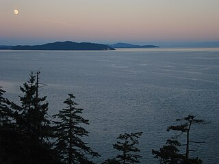
The Strait of Georgia or the Georgia Strait is an arm of the Salish Sea between Vancouver Island and the extreme southwestern mainland coast of British Columbia, Canada, and the extreme northwestern mainland coast of Washington, United States. It is approximately 240 kilometres (150 mi) long and varies in width from 20 to 58 kilometres. Along with the Strait of Juan de Fuca and Puget Sound, it is a constituent part of the Salish Sea.

Quadra Island is a large island off the eastern coast of Vancouver Island, in British Columbia, Canada. It is part of the Discovery Islands, in the Strathcona Regional District.

Queen Charlotte Strait is a strait between Vancouver Island and the mainland of British Columbia, Canada. It connects Queen Charlotte Sound with Johnstone Strait and Discovery Passage and via them to the Strait of Georgia and Puget Sound. It forms part of the Inside Passage from Washington to Alaska. The term Queen Charlotte Strait is also used to refer to the general region and its many communities, notably of the Kwakwakaʼwakw peoples. Despite its name, Queen Charlotte Strait does not lie between Haida Gwaii and the mainland; that body of water is named Hecate Strait.

The British Columbia Coast, popularly referred to as the BC Coast or simply the Coast, is a geographic region of the Canadian province of British Columbia. As the entire western continental coastline of Canada along the Pacific Ocean is in the province, it is synonymous with being the West Coast of Canada.

Princess Royal Island is the largest island on the North Coast of British Columbia, Canada. It is located amongst the isolated inlets and islands east of Hecate Strait on the British Columbia Coast. At 2,251 square kilometres (869 sq mi), it is the fourth largest island in British Columbia. It was named in 1788 by Captain Charles Duncan, after his ship Princess Royal.

Parts of this article have been adapted from the BC Parks website.

Quatsino Provincial Park is a provincial park in British Columbia, Canada, located on Quatsino Sound on northern Vancouver Island.

Port Renfrew is a small unincorporated community located on the south shore of Port San Juan, an inlet on the west coast of Vancouver Island in British Columbia, Canada. Port Renfrew has a population of 262 and has been touted as "the Tall Tree Capital of Canada".

Holberg is a former ferry terminal about 35 kilometres (22 mi) from the northwest tip of Vancouver Island, British Columbia. This unincorporated community is at the head of Holberg Inlet, which forms the western arm of Quatsino Sound.
The Salish Sea is a marginal sea of the Pacific Ocean located in the Canadian province of British Columbia and the U.S. state of Washington. It includes the Strait of Georgia, the Strait of Juan de Fuca, Puget Sound, and an intricate network of connecting channels and adjoining waterways.

Port Alice is a village of approximately 739 located on Neroutsos Inlet, southwest of Port McNeill, on Vancouver Island, originally built by Whalen Pulp and Paper Mills of Vancouver. The community is known for its natural environment, pulp mill, and salt water fishing.
The Haro Strait is one of the main channels connecting the Strait of Georgia to the Strait of Juan de Fuca, separating Vancouver Island and the Gulf Islands in British Columbia, Canada from the San Juan Islands of Washington state in the United States.

Milbanke Sound is a sound on the coast of the Canadian province of British Columbia.
Broughton Archipelago is a group of islands located at the eastern end of Queen Charlotte Strait in Mount Waddington Regional District, British Columbia. The archipelago is the traditional territory of the Musgamagw Dzawada'enuxw, Namgis, Ma'amtagila and Tlowitsis nations of the Kwakwaka'wakw peoples.

Victoria Harbour is a harbour, seaport, and seaplane airport in the Canadian city of Victoria, British Columbia. It serves as a cruise ship and ferry destination for tourists and visitors to the city and Vancouver Island. It is both a port of entry and an airport of entry for general aviation. Historically it was a shipbuilding and commercial fishing centre. While the Inner Harbour is fully within the City of Victoria, separating the city's downtown on its east side from the Victoria West neighbourhood, the Upper Harbour serves as the boundary between the City of Victoria and the district municipality of Esquimalt. The inner reaches are also bordered by the district of Saanich and the town of View Royal. Victoria is a federal "public harbour" as defined by Transport Canada. Several port facilities in the harbour are overseen and developed by the Greater Victoria Harbour Authority, however the harbour master's position is with Transport Canada.
Quatsino Sound is a complex of coastal inlets, bays and islands on northwestern Vancouver Island in the Canadian province of British Columbia. It is the northernmost of the five sounds that pierce the west coast of Vancouver Island, the others being Kyuquot Sound, Nootka Sound, Clayoquot Sound, and Barkley Sound.

Chelosin was a steel-hulled, steam-powered passenger-freighter vessel that served in coastal British Columbia from 1911 to 1949, under the ownership of the Union Steamship Company of British Columbia.

Port San Juan is an inlet along the Pacific coast of Vancouver Island in British Columbia, Canada. It was formed from the San Juan and Leech River faults which flank the northern and southern slopes of the San Juan Valley. The San Juan and Gordon rivers empty into the inlet from the northeast.
Scott Islands Marine National Wildlife Area is a National Wildlife Area off the northwestern tip of Vancouver Island in the Canadian province of British Columbia. Covering an area of 11,570.65 km2 (4,467.45 sq mi), it is the second largest protected area in British Columbia after Offshore Pacific Seamounts and Vents Closure and is the largest national wildlife area in Canada.


