Tioga County is a county in the Commonwealth of Pennsylvania. As of the 2020 census, the population was 41,045. Its county seat is Wellsboro. The county was created on March 26, 1804, from part of Lycoming County and later organized in 1812. It is named for the Tioga River. The county is part of the North Central Pennsylvania region of the state.

Bernville is a borough in Berks County, Pennsylvania, United States. The population was 905 at the 2020 census. Bernville is bordered by Penn Township to the north, east, and south and by Jefferson Township to the west. It is believed by few that the borough would have been a county seat of a small county called Tulpehocken County. However, no official sources can be found.

Delmar Township is a township in Tioga County, Pennsylvania, United States. The population was 2,796 at the 2020 census.

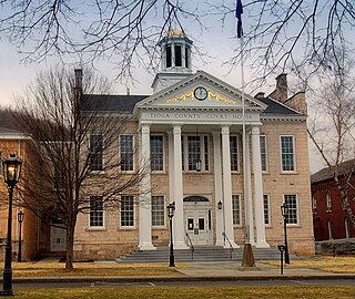
Wellsboro is a borough and county seat of Tioga County, Pennsylvania, United States. The borough was founded by Benjamin Wistar Morris. It is located 52 miles (84 km) northwest of Williamsport. The population was 3,472 at the 2020 census.

Codorus State Park is a 3,500-acre (1,400 ha) Pennsylvania state park in Heidelberg, Manheim, Penn, and West Manheim Townships in southwestern York County, Pennsylvania in the United States. The park was created around Lake Marburg, an artificial lake covering 1,275 acres (516 ha), and is named for Codorus Creek, which forms the lake. Codorus State Park is located on Pennsylvania Route 216, 3 miles (4.8 km) from the borough of Hanover.

Shawnee State Park is a 3,983-acre (1,612 ha) Pennsylvania state park in Juniata and Napier Townships, Bedford County, Pennsylvania in the United States. Shawnee Lake, a 451-acre (183 ha) warm water reservoir, is at the center of the park as its main attraction. The park's main entrance is just east of Schellsburg, along U.S. Route 30 and about 10 miles (16 km) west of the county seat of Bedford. The park is also easily accessed via State Route 31 and by State Route 96.

U.S. Route 6 (US 6) travels east–west near the north edge of the U.S. state of Pennsylvania from the Ohio state line near Pymatuning Reservoir east to the Mid-Delaware Bridge over the Delaware River into Port Jervis, New York. It is the longest highway segment in the commonwealth. Most of it is a two-lane rural highway, with some freeway bypasses around larger towns. Except east of Dunmore, where it is paralleled by Interstate 84 (I-84), it is the main route in its corridor. What is now I-80—the Keystone Shortway—was once planned along the US 6 corridor as a western extension of I-84. The corridor was originally the Roosevelt Highway from Erie, Pennsylvania, to Port Jervis, New York, designated Pennsylvania Route 7 (PA 7) in 1924. The PA 7 designation soon disappeared, but, as US 6 was extended and relocated, the Roosevelt Highway followed it. The Pennsylvania section of US 6 was renamed the Grand Army of the Republic Highway in 1946; this name was applied to its full transcontinental length by 1953.
Crooked Creek is a 26.3-mile-long (42.3 km) tributary of the Tioga River located entirely in Tioga County, Pennsylvania in the United States.

Little Pine State Park is a Pennsylvania state park on 2,158 acres (873 ha) in Cummings Township, Lycoming County, Pennsylvania in the United States. Little Pine State park is along 4.2 miles (6.8 km) of Little Pine Creek, a tributary of Pine Creek, in the midst of the Tiadaghton State Forest. A dam on the creek has created a lake covering 94 acres (38 ha) for fishing, boating, and swimming. The park is on Pennsylvania Route 4001, 4 miles (6.4 km) northeast of the unincorporated village of Waterville or 8 miles (13 km) southwest of the village of English Center. The nearest borough is Jersey Shore, Pennsylvania, about 15 miles (24 km) south at the mouth of Pine Creek on the West Branch Susquehanna River.

Yellow Creek State Park is a Pennsylvania state park on 2,981 acres (1,206 ha) in Brush Valley and Cherryhill Townships, Indiana County, Pennsylvania in the United States. The park encompasses parts of Yellow Creek and Little Yellow Creek. The old Kittanning Path goes through the parkland. The park was established in 1963. An additional 159 acres (64 ha) of developed land were purchased in 1982. Yellow Creek Lake, a 720-acre (290 ha) man-made lake, was built in 1969 by an earth and rock dam on Yellow Creek. Yellow Creek State Park is between the boroughs of Ebensburg and Indiana on U.S. Route 422.

Erie Bluffs State Park is a 587-acre (238 ha) Pennsylvania state park in Girard and Springfield Townships, Erie County, Pennsylvania in the United States. The park is the largest undeveloped stretch of land overlooking Lake Erie in Pennsylvania. Erie Bluffs State Park is just north of Pennsylvania Route 5 near Lake City and 12 miles (19 km) west of Erie. It is one of Pennsylvania's newest state parks.
Conewago Creek is a 23.0-mile-long (37.0 km) tributary of the Susquehanna River in Lebanon, Dauphin, and Lancaster counties in Pennsylvania in the United States. The source is at an elevation of 1,100 feet (340 m) at Mount Gretna Heights in Lebanon County. The mouth is the confluence with the Susquehanna River at an elevation of 261 feet (80 m) at the border of Dauphin and Lancaster counties, just south of Three Mile Island in the river and just north of the unincorporated village of Falmouth in Conoy Township, Lancaster County.
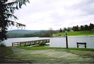
Hills Creek State Park is a 407-acre (165 ha) Pennsylvania state park in Charleston Township, Tioga County, Pennsylvania in the United States. Hills Creek Lake, a 137-acre (55 ha) man-made lake, is the focal point of the park. It is open for year-round recreation. Hills Creek State Park is in the Allegheny Plateau region of Pennsylvania, just north of U.S. Route 6 near the boroughs of Wellsboro and Mansfield.

Leonard Harrison State Park is a 585-acre (237 ha) Pennsylvania state park in Tioga County, Pennsylvania, in the United States. It is on the east rim of the Pine Creek Gorge, also known as the Grand Canyon of Pennsylvania, which is 800 feet (240 m) deep and nearly 4,000 feet (1,200 m) across here. It also serves as headquarters for the adjoining Colton Point State Park, its sister park on the west rim of the gorge. Leonard Harrison State Park is known for its views of the Pine Creek Gorge, and offers hiking, fishing and hunting, whitewater boating, and camping. The park is in Shippen and Delmar Townships, 10 miles (16 km) west of Wellsboro at the western terminus of Pennsylvania Route 660.

Gouldsboro State Park is a 2,880-acre (1,165 ha) Pennsylvania state park in Coolbaugh Township, Monroe County and Lehigh Township, Wayne County, Pennsylvania in the United States. The park includes the 250-acre (100 ha) Gouldsboro Lake. Gouldsboro State Park is located very close to Tobyhanna State Park and Pennsylvania State Game Lands 127 and 312. It is on Pennsylvania Route 507 near the small village of Gouldsboro.

Penns Valley is an eroded anticlinal valley of the Pennsylvania ridge and valley geologic region of the Appalachian Mountain range. The valley is located in southern Centre County, Pennsylvania. Along with the Nittany Valley to the north and east, it is part of the larger Nittany Anticlinorium. It is bordered by Mount Nittany to the north, the Seven Mountains range to the south, and connects to the larger Nittany Valley to the west. There are two smaller subordinate valleys typically associated with the greater valley: Georges Valley in the south, separated by Egg Hill, and Brush Valley in the north, separated by Brush Mountain.
The Pennsylvania Fish and Boat Commission is an independent state agency responsible for the regulation of all fishing and boating in the state of Pennsylvania within the United States of America. Unlike many U.S. states, Pennsylvania has a separate Game Commission.

Colyer is a small unincorporated community south of the borough of Centre Hall in central Potter Township, Centre County, Pennsylvania, United States.

Pennsylvania Route 660 is a 24.1-mile-long (38.8 km) state highway located in Tioga County in Pennsylvania. The western terminus is at the entrance of Leonard Harrison State Park in Shippen Township. The eastern terminus is at Interstate 99 (I-99) in Richmond Township.
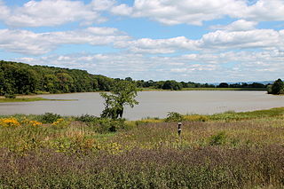
The Briar Creek Reservoir is a reservoir in Columbia County, Pennsylvania, in the United States. It has an area of 51.04 acres and is located in Briar Creek Township. The lake is situated on East Branch Briar Creek. The lake was constructed in the early 1970s for the purpose of flood control. It is dammed by the Briar Creek Dam. Shale and limestone rocks are found in the lake's vicinity. The lake was electrofished by the Pennsylvania Fish and Boat Commission in 2010. The reservoir is designated as Approved Trout Waters and is stocked with trout. More than a dozen species of fish inhabit it and several bird species are found in its vicinity. The lake is part of the 173-acre Briar Creek Lake Park. Fishing and boating are done in the reservoir.


