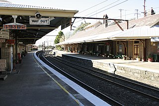
Mount Victoria railway station is a heritage-listed former barracks and now staff accommodation, guest accommodation, railway signal box and railway station located on the Main Western line in Mount Victoria in the City of Blue Mountains local government area of New South Wales, Australia. It was designed by NSW Government Railways and built from 1868 to 1913 by Allan McClean and James Barrie (1868 building). It is also known as Mount Victoria Railway Station group. The property was added to the New South Wales State Heritage Register on 2 April 1999. The station opened on 6 September 1869.

Stoneacre is a small National Trust property in Otham, near Maidstone, Kent in southern England. The property is a half-timbered yeoman farmer's house dating from the 15th century, together with a small garden, orchard and meadows. The house is a Grade II* listed building.
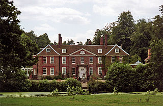
Chilston Park is a country house in Boughton Malherbe, Kent, England. Started in the 15th century, the house has been modified many times and is a Grade I listed building, currently operated as a country house hotel.

St Mary the Virgin is a parish church in Nettlestead, Kent, begun in the 13th century.

Boughton Monchelsea Place, previously Boughton Court, is a 16th-century country house in Boughton Monchelsea, Kent, England. The first part of the house was built by Robert Rudston circa 1567–75 on the site of an earlier manor house. It has been modified a number of times during its history achieving its present form in 1819. It has been a home to a number of members of parliament for Maidstone or for Kent, including Sir Francis Barnham, Sir Robert Barnham (1646–85) Sir Barnham Rider (1698–1728) and Thomas Rider (1805–47).

West Farleigh Hall, previously known as Smith's Hall, is an 18th-century country house in West Farleigh, Kent.

St John the Baptist's Church is a parish church in Marley Road, Harrietsham, Kent dedicated to John the Baptist. It was begun in the late 11th century or in the 12th century and works continued to the 15th century. The church is a Grade I listed building.

St Peter's and St Paul's Church is a parish church in Yalding, Kent, dedicated to saints Peter and Paul. It was begun in the 13th century and is a Grade I listed building.

Mansion House is a prominent and historically significant Grade II* listed Georgian village property in Hurstpierpoint, West Sussex, England. The substantial family home is situated in the heart of Hurstpierpoint with the High Street at the front and South Downs to the rear. The brick faced timber framed building has surviving medieval sections dating back to the mid to late 16th century.

Toowoomba Police Station Complex is a heritage-listed police station at 50-52 Neil Street, Toowoomba, Queensland, Australia. It was designed by Raymond Clare Nowland and built in 1935. It was added to the Queensland Heritage Register on 5 October 1998.
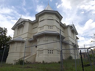
Keating House is a heritage-listed villa at 10-12 Westminster Road, Indooroopilly, City of Brisbane, Queensland, Australia. It was designed by Richard Gailey and built c. 1890s. It is also known as Louis Stamm residence. It was added to the Queensland Heritage Register on 28 May 1999.

Thurstaston Hall is a country house in the village of Thurstaston, Wirral, Merseyside, England. The house is built in stone and brick, it is in two storeys, and it has a U-shaped plan. The oldest part, the west wing, was built in the 14th century, the central block dates from 1680, and the east wing was added in 1836. The hall is recorded in the National Heritage List for England as a designated Grade II* listed building, and the gate piers in the drive leading to the hall are designated Grade II.

Our Lady of Assumption Convent is a heritage-listed former Roman Catholic convent at 8 Locke Street, Warwick, Southern Downs Region, Queensland, Australia. It was designed by Simkin & Ibler and built from 1891 to 1914. It is also known as Assumption College, Cloisters, and Sophia College. It was added to the Queensland Heritage Register on 21 October 1992.
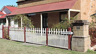
Pringle Cottage is a heritage-listed cottage at 81 Dragon Street, Warwick, Southern Downs Region, Queensland, Australia. It was built from 1860s/1870s onwards by John McColluch. It is also known as John McCulloch's Cottage, Mountview, Milton College, and Miss Lukin's Boarding School. It was added to the Queensland Heritage Register on 21 October 1992.

Killochan Castle is a 16th-century L-plan tower house about 3 miles (4.8 km) north east of Girvan, South Ayrshire, Scotland, north of the Water of Girvan, and south of Burnhead.

All Hallows' School Buildings are a heritage-listed group of Roman Catholic private school buildings at 547 Ann Street, Fortitude Valley, City of Brisbane, Queensland, Australia. They were designed by a number of notable Brisbane architects and were constructed over many years. The earliest is the All Hallows Convent, also known as Adderton. The buildings were added to the Queensland Heritage Register on 21 October 1992.

Dalcross Castle is a restored 17th century tower house, about 1+1⁄2 miles southwest of Croy, Highland, Scotland, and about 7 miles northeast of Inverness. The castle stands on a ridge.
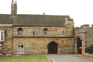
The Vicars’ Court or Vicars’ Choral in Lincoln, is situated in the Minster Yard to the south of Lincoln Cathedral. It was founded as a college of priests by Bishop Sutton in the late 13th, century. These priests would take services in the Cathedral in the absence of the Prebendaries. The Vicars ‘ Choral of Lincoln is one of eight such colleges in England, and it is also one of the earliest, best preserved and the most interesting. The great majority of the building survives. By 1305 the hall, the kitchen and certain chambers were finished. In 1328 lay brothers were admitted and further houses were built for them During the English Civil War, the buildings were badly damaged and afterwards were converted into four houses.
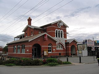
Euroa Post Office is a heritage-listed post office at 90 Binney Street, Euroa, Victoria, Australia. It was designed by John Thomas Kelleher of the state Public Works Department, possibly with the assistance of A. J. McDonald, and built in 1890 by George Diggle. It was added to the Australian Commonwealth Heritage List on 22 August 2012.

Hawkswood is a townland in the civil parish of Kinawley, barony of Tullyhaw, County Cavan, Ireland. The original Irish place name was Cluain Caomh meaning 'The Beautiful Meadow'. The town of Swanlinbar is partially situated in Hawkswood. According to the 1938 Dúchas collection two sub-divisions are- The Cleity - A name given to a field in a farm owned by Mr. Patrick Maguire, Hawkswood, Swanlinbar, Co. Cavan. The Rhythars - a name given to a field in a farm owned by Mr Hugh McBrien, Hawkswood, Swanlinbar.

