
Golcar is a village on a hillside crest above the Colne Valley in the Metropolitan Borough of Kirklees in West Yorkshire, England, 3 miles (5 km) west of Huddersfield, and just north of the River Colne and the Huddersfield Narrow Canal.

Kirklees is a metropolitan borough of West Yorkshire, England. The borough comprises the ten towns of Batley, Birstall, Cleckheaton, Dewsbury, Heckmondwike, Holmfirth, Huddersfield, Meltham, Mirfield and Slaithwaite. It is governed by Kirklees Council. Kirklees had a population of 422,500 in 2011; it is the third-largest metropolitan district in England by area, behind Doncaster and Leeds.
Marsden is a large village in the Colne Valley, in the metropolitan borough of Kirklees, West Yorkshire, England. It is in the South Pennines close to the Peak District which lies to the south. The village is 7 miles (11 km) west of Huddersfield at the confluence of the River Colne and Wessenden Brook. It was an important centre for the production of woollen cloth. In 2020, the village had an estimated population of 3,768.

Meltham is a town and civil parish within the Metropolitan Borough of Kirklees, in West Yorkshire, England. It lies in the Holme Valley, below Wessenden Moor, 5 miles south-west of Huddersfield on the edge of the Peak District National Park. It had a population of 8,089 at the 2001 census, which was estimated to have increased to 8,600 by 2005. The population assessed at the 2011 Census was 8,534. It has 12 elected council members who meet up around every 6 weeks.

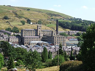
Slaithwaite is a town and former civil parish in the Colne Valley area of the metropolitan borough of Kirklees, in West Yorkshire, England. Historically part of the West Riding of Yorkshire, it lies in the Colne Valley, lying across the River Colne and the Huddersfield Narrow Canal, approximately 5 miles (8 km) south-west of Huddersfield.

Huddersfield is a town in the Metropolitan Borough of Kirklees in West Yorkshire, England. It is the administrative centre and largest settlement in the Kirklees district. The town is in the foothills of the Pennines. The River Holme's confluence into the similar-sized Colne is to the south of the town centre which then flows into the Calder in the north eastern outskirts of the town.

The Colne Valley is a steep sided valley on the east flank of the Pennine Hills in the English county of West Yorkshire. It takes its name from the River Colne which rises above the town of Marsden and flows eastward towards Huddersfield.

Colne Valley is a constituency represented in the House of Commons of the UK Parliament since 2024 by Paul Davies of the Labour Party.

The Moorside Edge is a steeply sloping area of moorland at grid reference SE070154 just north of Slaithwaite and about 5 miles (8 km) west of Huddersfield in the Kirklees District of West Yorkshire, England. It descents from the relatively flat summit of Pole Moor into the valley of the River Colne.

Netherton is a village, near Huddersfield, in the Kirklees metropolitan borough of West Yorkshire, England. It is 2 miles (3 km) south-west of the town centre on the road to Meltham. Netherton together with South Crosland have a population of 3,702 according to the 2001 census.

Milnsbridge is a district of Huddersfield, West Yorkshire, England, situated 2 miles (3 km) west of the town centre, and in the Colne Valley. The name is said to have derived from the water-powered mill and the bridge that stood alongside it in the 13th century.

Scapegoat Hill is a small village 5 miles (8 km) west of Huddersfield, West Yorkshire, England. It is near to the villages of Slaithwaite and Golcar. The village together with nearby Bolster Moor has a population of 1,246.

The Huddersfield and District Association League is a football competition based in the area of Huddersfield, England. It was founded in 1898. The league has a total of five senior divisions. The highest senior division, Premier Division, sits at level 14 of the English football league system and is a feeder to the West Yorkshire and Yorkshire Amateur Leagues.

Royds Hall Academy is a mixed secondary school for pupils aged 11 – 16. It is located in Huddersfield, West Yorkshire, England, and on the north side of the Colne Valley towards Milnsbridge.
Colne Valley was an urban district in the West Riding of Yorkshire, England between 1937 and 1974. It takes its name from the River Colne which rises above the town of Marsden and flows eastward towards Huddersfield.

Wilberlee is a hamlet in the Colne Valley, in the Kirklees district, in the county of West Yorkshire, England. It is near the town of Huddersfield and the village of Slaithwaite. Wilberlee has a school called Wilberlee Junior and Infant School.
Pole Moor is a hamlet between Outlane and Scammonden in Kirklees, England. It is situated on a high moorland plateau between Slaithwaite and Wholestone Moors in the South Pennines.
Paul Salveson,, is an English politician, activist and author. He is currently a visiting professor in transport and logistics at the University of Bolton and University of Huddersfield.
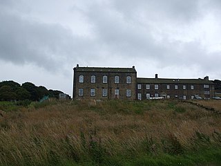
Slaithwaite Town Hall, also known as Empire House is a former municipal building in Lewisham Road in the town of Slaithwaite, West Yorkshire, England. The building, which served as the offices of Colne Valley Urban District Council, is now a business centre.

