The Kennet is a tributary of the River Thames in Southern England. Most of the river is straddled by the North Wessex Downs AONB. The lower reaches have been made navigable as the Kennet Navigation, which – together with the Avon Navigation, the Kennet and Avon Canal and the Thames – links the cities of Bristol and London.

The River Rother flows from Empshott in Hampshire, England, to Stopham in West Sussex, where it joins the River Arun. At 52 kilometres (32 mi) long, most of the river lies within West Sussex except for the first 10 kilometres (6.2 mi) which lie in Hampshire. The upper river, from its source to Midhurst, has been used to power watermills, with the earliest recorded use being in 1086, when the Domesday survey was conducted. Although none are still operational, many of the buildings which housed the mills still exist, and in some cases, still retain their milling machinery. This upper section is also noted for a number of early bridges, which have survived since their construction in the fifteenth, sixteenth and seventeenth centuries.

The Moss is a brook in North East Derbyshire, England.

Castle Combe is a village and civil parish within the Cotswolds Area of Outstanding Natural Beauty in Wiltshire, England. The village is around 5 miles (8 km) north-west of Chippenham. A castle once stood in the area, but was demolished centuries ago.
The Frome, historically the Froom, is a river that rises in Dodington Park, South Gloucestershire and flows southwesterly through Bristol to join the river Avon. It is approximately 20 miles (32 km) long, and the mean flow at Frenchay is 60 cubic feet per second (1.7 m3/s). The name Frome is shared with several other rivers in South West England and means 'fair, fine, brisk'. The river is known locally in east Bristol as the Danny.

The River Allen is a river in the county of Dorset in South West England. It flows for 14 miles (23 km) to its confluence with the River Stour immediately south of Wimborne Minster, between that town and the village of Oakley. It has two main tributaries, the Gussage Stream and the Crichel Stream.

The River Chess is a chalk stream that rises near Chesham in the Chiltern Hills, and flows for 11 miles (18 km) through Buckinghamshire and Hertfordshire to its confluence with the River Colne in Rickmansworth. The Chess, along with the Colne and Gade, gives rise to the name of the district of Three Rivers.
Millhouses is a neighbourhood in the City of Sheffield, England. It is located in Ecclesall ward; in the south-western portion of the city on the northwest bank of the River Sheaf. Its origins lie in a small hamlet that grew around the Ecclesall Corn Mill. It has a population of 4,424.

Biddestone is a village and former civil parish, now in the parish of Biddestone and Slaughterford, in the Wiltshire district, in northwest Wiltshire, England, about 3 miles (5 km) west of Chippenham and 2 miles (3.2 km) north of Corsham. The parish includes the smaller settlement of Slaughterford.

Midford is a village approximately 3 miles (5 km) south-south-east of Bath, Somerset, England. Although relatively small, it extends over 2 counties, is part of two unitary authorities and is part of five parishes. Although all five parishes extend very near to the village centre, most of the residents reside in the parish of Southstoke and are part of the Bath and North East Somerset unitary authority.
Leigh Delamere is a small village in the civil parish of Grittleton in the English county of Wiltshire, about 4 miles (6 km) northwest of the town of Chippenham. The M4 motorway passes some 250 metres to the south, and the motorway's Leigh Delamere services lie to the east of the village.
Yatton Keynell is a village and civil parish in Wiltshire, England. The village is on the B4039 road near Castle Combe, about 4 miles (6 km) northwest of Chippenham, and about the same distance to the east of the county border with South Gloucestershire.

The River Whitewater rises at springs near Bidden Grange Farm between Upton Grey and Greywell in Hampshire, England. It flows northeast and is a tributary of the River Blackwater near Swallowfield. Its headwaters flow over chalk and there is little pollution making the River Whitewater rich in wildlife. It was noted on Jansson's map of Hampshire of 1646.
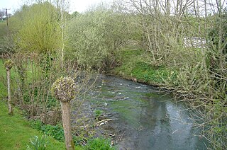
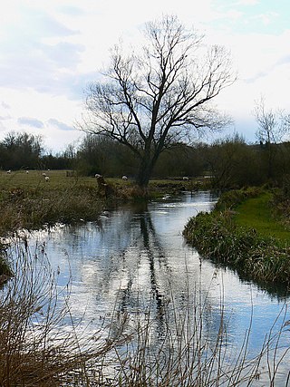
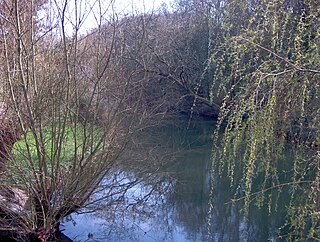
The Bybrook, also known as the By Brook, is a small river in England. It is a tributary of the Bristol Avon and is some 12 miles (19 km) long. Its sources are the Burton Brook and the Broadmead Brook, which rise in South Gloucestershire at Tormarton and Cold Ashton respectively, and join just north of Castle Combe in Wiltshire. The river has a mean flow rate of 57.25 cubic feet per second (1.621 m3/s) as recorded at Middlehill near Box. A variety of flora and fauna is supported by the river including the endangered white-clawed crayfish. Twenty watermill sites have been identified on the river but none now remain in use.

Burton is a small village in the Cotswolds Area of Outstanding Natural Beauty in Wiltshire, England. Kelly's 1915 Directory of Wiltshire identifies Burton as the most important part of the parish of Nettleton. It is about 8 miles (13 km) west of Chippenham.

The Tetbury Avon, also known as the River Avon, Little Avon or Ingleburn, is a tributary of the Bristol Avon in south-west England. It rises at Tetbury in Gloucestershire and flows in a generally south-easterly direction, joining the Sherston Avon at Malmesbury in Wiltshire. The water flow has been reduced by public water extraction from its source aquifer in the Cotswold Hills. In the past watermills were used for fulling wool and grinding corn; one working mill survives.
Nettleton is a village and civil parish about 6.5 miles (10.5 km) northwest of Chippenham in Wiltshire, England. The parish includes the villages of Burton and West Kington, and the hamlets of Horsedown, Nettleton Shrub and West Kington Wick. The northern section of Nettleton village is known as Nettleton Green.

West Kington is a village in Nettleton civil parish in Wiltshire, England. The village lies in the steeply wooded valley of the Broadmead Brook, a source of the Bybrook River, and is close to the county boundary with Gloucestershire. It is 6 miles (10 km) southeast of the Gloucestershire market town of Chipping Sodbury. The hamlet of West Kington Wick is 0.6 miles (0.97 km) southeast of the village at grid reference ST 8163 7665.

Bow Brook is a small river in the English county of Hampshire, which is a tributary of the River Loddon. Contributary streams rise near Ramsdell and Sherborne St John, and after flowing through rural countryside, it joins the Loddon near Sherfield on Loddon. Historically it has powered at least two watermills.

Lindhurst is a civil parish and hamlet in the Newark and Sherwood district, is 120 miles (190 km) north west of London, 11 miles (18 km) north of Nottingham the county town, and 3 miles (4.8 km) south east of Mansfield, the nearest market town and bordering its district border. It sits within western Nottinghamshire county, England.

