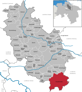
Visselhövede is a town in the district of Rotenburg in Lower Saxony, Germany. Nearby towns include the district capital Rotenburg, Walsrode and Verden. Larger cities within a 100 km radius are Bremen, Hanover and Hamburg.
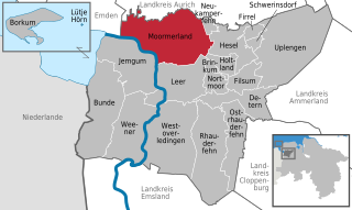
Moormerland is a municipality in the Leer District, in Lower Saxony, northwestern Germany.

Adendorf is a municipality in the district of Lüneburg, in Lower Saxony, Germany.
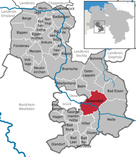
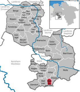
Bissendorf is a municipality in the district of Osnabrück, in Lower Saxony, Germany. It is situated approximately 9 km southeast of Osnabrück. Population 14,700 (2020).
Geeste is a municipality in the district Emsland in Lower Saxony.
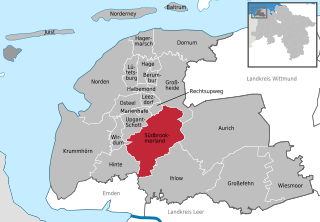
Südbrookmerland is a municipality in the district of Aurich, in Lower Saxony, Germany. It is situated approximately 7 km west of Aurich. Its seat is in the village Victorbur.

Sulingen is a town in the district of Diepholz, Lower Saxony, Germany. It is situated approximatively 30 km east of Diepholz, and 45 km south of Bremen.
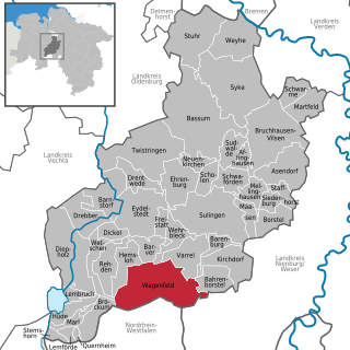
Wagenfeld is a municipality in the district of Diepholz, Lower Saxony, Germany. It is situated approximately 15 km east of Diepholz, and 40 km northwest of Minden.

Emsbüren is a municipality in the Emsland district, Lower Saxony, Germany. It is situated on the river Ems, approx. 15 km south of Lingen, and 15 km northwest of Rheine.

Rhede is a municipality in the Emsland district, Lower Saxony, Germany. It is situated on the river Ems, near the border with the Netherlands, approx. 10 km west of Papenburg, and 20 km southeast of Winschoten.

Salzbergen is a municipality in the Emsland district, Lower Saxony, Germany. It is situated on the river Ems, approx. 25 km south of Lingen, and 10 km northwest of Rheine.
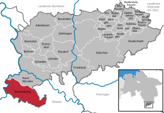
Staufenberg is the southernmost municipality of the district of Göttingen, and of Lower Saxony, Germany. It is situated east of the river Fulda, approx. 6 km south of Hannoversch Münden, and 12 km northeast of Kassel. Its seat is in the village Landwehrhagen.

Holle is a village and a municipality in the district of Hildesheim, in Lower Saxony, Germany. It is situated approximately 15 km southeast of Hildesheim, and 15 km west of Salzgitter. It was mentioned in Tom Clancy's bestseller Red Storm Rising.

Steyerberg is a municipality in the district of Nienburg, in Lower Saxony, Germany. It is situated approximately 15 km southwest of Nienburg, and 30 km north of Minden.
Bad Rothenfelde is a municipality and health resort in the district of Osnabrück, in Lower Saxony, Germany.

Hagen is a municipality in the district of Osnabrück, in Lower Saxony, Germany. It is situated in the Teutoburg Forest, approx. 10 km southwest of Osnabrück.

Gnarrenburg is a municipality in the district of Rotenburg, in Lower Saxony, Germany. It is situated approximately 15 km southwest of Bremervörde, and 40 km northeast of Bremen.

Obernkirchen is a town in the district of Schaumburg, in Lower Saxony, Germany. It is situated approximately 8 km southwest of Stadthagen, and 15 km east of Minden.

Friedeburg is a municipality in the district of Wittmund, in Lower Saxony, Germany. It is situated approximately 14 km southeast of Wittmund, and 20

Geestland is a town in the district of Cuxhaven, in Lower Saxony, Germany. It was formed on 1 January 2015 by the merger of the former municipalities of Langen bei Bremerhaven, Bad Bederkesa, Drangstedt, Elmlohe, Flögeln, Köhlen, Kührstedt, Lintig and Ringstedt.


