
Milbertshofen, Am Riesenfeld and Am Hart are three boroughs situated in the north of Munich in Germany. Jointly, they form the city district 11 Milbertshofen-Am Hart. As of December 2016, the three boroughs had 76,255 inhabitants.

Am Hart is the northernmost of the three sub-districts of the Munich city district 11 Milbertshofen-Am Hart.

Bogenhausen is the 13th borough of Munich, Germany. It is the geographically largest borough of Munich and comprises the city's north-eastern quarter, reaching from the Isar on the eastern side of the Englischer Garten to the city limits, bordering on Unterföhring to the north, Aschheim to the east and the Haidhausen borough to the south.

Altstadt and Lehel are districts of the German city of Munich. Together they form the first borough of the city: Altstadt-Lehel.
Hadern is the 20th borough of the Bavarian city of Munich in Germany.

Au is a district in the south eastern plain tract of the German city of Munich in Bavaria. Au extends from the Deutsches Museum in the north and along the Isar up to Wittelsbacherbrücke in the south.

Trudering-Riem is the 15th borough (Stadtbezirk) of Munich, Bavaria, consisting of the quarters (Stadtteile) Trudering and Riem. This area is the former location of Munich's old airport, Riem Airport.

Thalkirchen-Obersendling-Forstenried-Fürstenried-Solln is the 19th borough of Munich, Germany, comprising the extreme southern part of the city on the west bank of the river Isar. After the administrative reform, the boroughs Thalkirchen-Obersendling-Forstenried and Solln were incorporated, thus forming the new borough. It comprises 17.7631 square kilometres and has a population of 96,714 residents.

Untergiesing-Harlaching is the 18th borough of Munich, Germany, mostly the districts of Untergiesing and Harlaching. The borough's western border is the river Isar, in the south it borders on Grünwald and the Perlacher Forst [German-language Wiki: Perlacher Forst], to the north-west on the Munich borough of Obergiesing and to the north on the borough of Au-Haidhausen.
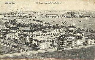
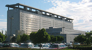
The Eisenbahnkaserne was a military barracks in Munich that existed from 1890 to 1976. The "Kasernement des Eisenbahnbataillons" was built in 1888 and 1889. It was located west of today's Olympiapark on Dachauer Straße, where the Bundeswehr Administration Centre is now located.

Ludwigsvorstadt-Isarvorstadt is one of the boroughs of Munich, Germany.

Haidhausen is a quarter of Munich, Germany. It is now part of the borough—or stadtbezirk—number 5 Au-Haidhausen.

Neuhausen and Nymphenburg were boroughs of Munich, the capital of the German state of Bavaria. They were merged into the borough 09 - Neuhausen-Nymphenburg in 1992. For further information on the Munich boroughs, see: Boroughs of Munich.

The Einkaufs-Center Neuperlach – pep is a shopping mall in Munich's Neuperlach borough operated by ECE. With a floor space of 60,000 square meters and about 135 specialty shops, it was according to a survey for the year 2002, the most profitable shopping center in Germany, the average revenue per square meter was twice as high as the national average. In designing the state capital, it is recognized as an integrated site with the function of a district center, and through its size has an important role for the entire southeast of the metropolitan Munich.
The Roman Catholic Deanery of Munich Perlach (German: "Dekanat München-Perlach") is a deanery of the Roman Catholic Church in the Archdiocese of Munich and Freising. At the moment, eight parishes belong to the deanery and there are currently c.48,000 Catholics living in the deanery, which roughly encompasses the area of district number 16 of the City of Munich, "Ramersdorf-Perlach" and the area of the municipality Neubiberg, south-east of Munich. The diocesan agenda for structural reorganization regrouped the eight parishes as three pastoral unions and the borough parish ("Stadtteilkirche") of Neuperlach. The new common patronage of "Christ the Redeemer") fused five previously independent parishes. The Dean is Christian Penzkofer and the Sub-Dean is Bodo Windolf.

Ramersdorf-Perlach is a borough of Munich. It is located south-east of the city center and is the most populous of Munich's boroughs with a population of about 116,000. It consists of the five districts Ramersdorf, Balanstraße West, Altperlach, Neuperlach and Waldperlach.
The Balanstraße is a street in Munich which begins at the Rosenheimer Platz and runs in a southerly direction through the districts Haidhausen, Giesing and Ramersdorf to the district of Fasangarten. It ends at the border road directly on the city boundary to the municipality Neubiberg in the district of Munich.

The Munich Fire Department is the firefighting authority of the City of Munich. The Munich fire department is divided into a professional department with approximately 1500 fire fighters staffing a total of 10 fire stations located strategically throughout the city to meet the legal aid period of 10 Minutes, and a volunteer fire department, whose approximately 1,050 members are organized in 22 companies. Each year, the Munich Fire Department responds to about 80,000 calls. The volunteers respond to about 3,500 calls annually. This makes the Munich Fire Department the third largest fire department as well as the largest municipal fire department in Germany.

Munich East is an electoral constituency represented in the Bundestag. It elects one member via first-past-the-post voting. Under the current constituency numbering system, it is designated as constituency 218. It is located in southern Bavaria, comprising the eastern part of the city of Munich.
