State Route 599 is a 7.049-mile (11.344 km) state highway in Clark County, Nevada. The route follows Rancho Drive, a major arterial connecting downtown Las Vegas to the northwest part of the city. Much of SR 599 was previously designated as U.S. Route 95 prior to completion of the Las Vegas Expressway. The route is also designated as U.S. Route 95 Business.

State Route 88 is a 7.868-mile (12.662 km) north–south state highway in the Carson Valley in western Douglas County, Nevada, United States. It runs from the California state line along Woodfords Road to U.S. Route 395 in Minden. Prior to 1957, the highway existed as State Route 37.
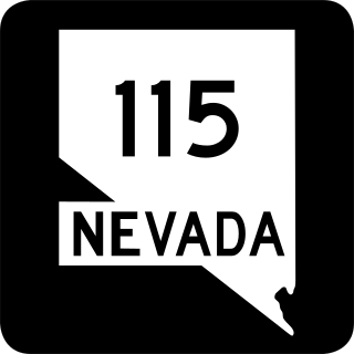
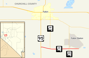
State Route 115 is a state highway outside the city of Fallon, Nevada in the United States. Known as Harrigan Road, SR 115 starts at an intersection with SR 119 and runs north to an intersection with Stillwater Avenue, paralleling U.S. Route 95.

State Route 120 is a state highway in Churchill County, Nevada. It connects U.S. Route 95 to State Route 119 just outside Naval Air Station Fallon.

State Route 206 is a state highway in Douglas County, Nevada, United States. It runs northwest from State Route 88 near the California state line along Foothill Road to Genoa, and then turns east on Genoa Lane to end at U.S. Route 395.

State Route 225 is a state highway in Elko County, Nevada, United States. Known as the Mountain City Highway, it connects the city of Elko to the town of Owyhee near the southwestern Idaho border via Mountain City. The route provides connections to Mountain Home, Idaho and Interstate 84 via Idaho State Highway 51.
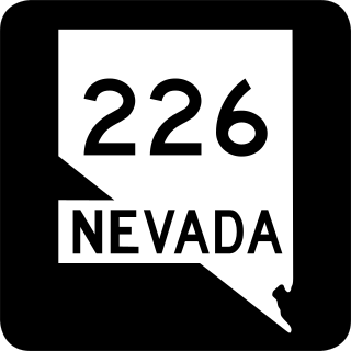
State Route 226 is a state highway in Elko County, Nevada, United States. It spurs off State Route 225 north of Elko, and heads north for 39 miles (63 km) to Deep Creek.

State Route 265 is a 20.5-mile (33.0 km) state highway in Esmeralda County, Nevada, United States. Referred to as Silver Peak Road, it connects the community of Silver Peak to U.S. Route 6 and U.S. Route 95. The route formerly existed as State Route 47.

State Route 267 is a 21.427-mile (34.483 km) state highway in Nevada, United States. Known as Scotty's Castle Road, the highway connects Death Valley National Park to U.S. Route 95. The route was previously designated State Route 72.
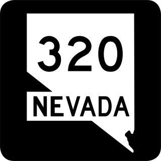
State Route 320 is a state highway in Lincoln County, Nevada, United States. Known as the Caselton Mine Loop, the highway is a loop route of U.S. Route 93 near Pioche serving the Caselton Mining District.
State Route 359 is a state highway in Mineral County, Nevada, in the United States. It starts from where California State Route 167 ends at the California stateline and continues the road on north to U.S. Route 95 in Hawthorne. Prior to the 1976 mass renumbering of Nevada State Routes SR 359 was numbered Nevada State Route 31.

U.S. Route 95 Truck is a truck route of US 95 in Mineral County, Nevada, in the United States. It serves as a bypass route for trucks taking US 95 past Hawthorne in either direction, as US 95 itself goes through that community. The route is co-designated as State Route 362 (SR 362); however, that designation is unsigned.

State Route 373 is a 16.304-mile-long (26.239 km) state highway in Nye County, Nevada, United States. It is a highway connecting California State Route 127 to U.S. Route 95, providing southern Nye County access to the eastern areas of Death Valley National Park.
State Route 374 is a state highway in Nye County, Nevada, United States. It serves as Nevada's gateway to Death Valley National Park, connecting the park to Beatty. The highway was known as State Route 58 prior to 1976.
State Route 487 is a north–south state highway in White Pine County, Nevada. The route follows Baker Road from the Utah–Nevada state line southeast of Baker to U.S. Route 6 and U.S. Route 50. The route was previously known as State Route 73 prior to 1976. SR 487 is designated as a Nevada Scenic Byway.

State Route 488 is an east–west state highway in White Pine County, Nevada. The route covers Lehman Caves Road connecting the town of Baker to Great Basin National Park. The route existed as State Route 74 prior to 1976. SR 488 has been designated a Nevada Scenic Byway.

State Route 647 is a state highway in Washoe County, Nevada. The route currently comprises a portion of West Fourth Street in Reno and a short segment of Prater Way in Sparks. The route previously extended a greater distance east–west through Reno–Sparks, and was formerly designated as part of U.S. Route 40.

State Route 773 is a 10.496-mile-long (16.892 km) state highway in Esmeralda County, Nevada, United States. Known as Fish Lake Valley Road, the highway was a part of former SR 3A.

State Route 446 is a 13.156-mile-long (21.173 km) state highway serving Washoe County, Nevada. The route runs from SR 445 to SR 447 at the town of Nixon.