
State Route 147 is a state highway serving the Las Vegas Valley in southern Nevada. It is signed as Lake Mead Boulevard and runs from Interstate 15 (I-15) and U.S. Route 93 in North Las Vegas east to the border of the Lake Mead National Recreation Area. It is not to be confused with Lake Mead Parkway, which also goes to Lake Mead but mainly runs in southern Las Vegas Valley and carries the designation of State Route 564.

State Route 116 is a state highway in Churchill County, Nevada, United States. Known as Stillwater Road, it connects the small town of Stillwater to U.S. Route 50 east of Fallon. The road was established by 1940 as SR 42, and was renumbered to SR 116 in 1976.
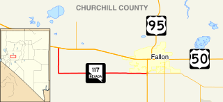
State Route 117 is a state highway in Churchill County, Nevada. The route serves farm areas around the southwest side of the city of Fallon.
State Route 118 is a state highway in Churchill County, Nevada. It serves the southeast portion of Fallon near northern edge of Naval Air Station Fallon. Prior to 1976, the route was designated as State Route 62.

State Route 120 is a state highway in Churchill County, Nevada. It connects U.S. Route 95 to State Route 119 just outside Naval Air Station Fallon.

State Route 228 (SR 228), also known as Jiggs Highway, is a 20.803-mile (33.479 km) state highway in Elko County, Nevada, United States, that connects Jiggs with Nevada State Route 227 in Spring Creek.
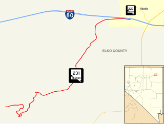
State Route 231 is an unsigned state highway in Elko County, Nevada, United States. Known as Angel Lake Road, the highway connects Angel Lake to the town of Wells. SR 231 is a Nevada Scenic Byway.
State Route 294 is a 7.973-mile (12.831 km) state highway in southeastern Humboldt County, Nevada, United States, that runs along the northernmost part of Grass Valley Road and connects Winnemucca with the Grass Valley area south of the town.
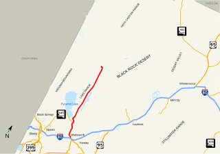
State Route 447 is a state highway in the U.S. state of Nevada. The highway is almost entirely within Washoe County but does for a brief time enter Pershing County, Nevada. The highway connects the town of Gerlach to the remainder of the state via Wadsworth. Though passing through extremely remote and desolate areas of Nevada, the highway has recently gained fame as the primary route to access the Black Rock Desert, the site of the annual Burning Man festival. The state maintained portion ends at Gerlach; however the highway continues as Washoe County Route 447 from Gerlach north to the California state line near Cedarville.
State Route 578 is a short state highway in Clark County, Nevada. It comprises a 0.661-mile (1.064 km) portion of Washington Avenue in Las Vegas.
State Route 878 is a short state highway in Washoe County, Nevada. The highway is known as Slide Mountain Road.
State Route 856 is a state highway in Pershing County, Nevada serving Lovelock. The western portion of the route is also signed as Interstate 80 Business.
State Route 858 was a short state highway in Pershing County, Nevada.
State Route 648 runs from Kietzke Lane east along E. Second Street in Reno and Glendale Avenue in Sparks to S. McCarran Boulevard.
State Route 705 is a short 0.928-mile-long (1.493 km) state highway in Douglas County, Nevada. The route follows a portion of Clear Creek Road just south of Carson City. The route was once part of the Lincoln Highway, forming a major travel link between Carson City and Lake Tahoe. SR 705 was designated in 2000, and was only truncated once.

State Route 854 is a state highway in Pershing County, Nevada serving the vicinity of Lovelock. The route comprised a portion of former State Route 48.
State Route 398 is a state highway in Pershing County, Nevada serving the city of Lovelock. Part of the highway is former State Route 66.
State Route 760 is a short state highway in Douglas County, Nevada, United States. It connects Nevada Beach to U.S. Route 50. The route was established in 1976.
State Route 399 is an 18.18-mile (29.26 km) state highway in Pershing County, Nevada. It connects Eagle-Picher Mine to Lovelock, the nearest town.
State Route 822 is a short, east–west highway in Lyon County, Nevada. The route serves the town of Dayton.


