State Route 170 is a state highway in northeastern Clark County, Nevada. Also known as Riverside Road, the route serves the Riverside townsite, the town of Bunkerville and the city of Mesquite. The highway was previously a part of former U.S. Route 91.
State Route 318 is a state highway in eastern Nevada. It is often used as a shortcut for long-distance traffic along U.S. Route 93, bypassing the longer and less direct route U.S. Route 93 follows between Ely and Crystal Springs. The highway was established in the 1930s as State Route 38 and State Route 38A, and was renumbered to SR 318 in 1976. At a total of 110.762 miles (178.254 km), it is the longest state route in Nevada. The road is used for open speed highway races twice a year.
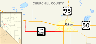
State Route 117 is a state highway in Churchill County, Nevada. The route serves farm areas around the southwest side of the city of Fallon.
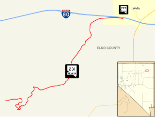
State Route 231 is an unsigned state highway in Elko County, Nevada, United States. Known as Angel Lake Road, the highway connects Angel Lake to the town of Wells. SR 231 is a Nevada Scenic Byway.

State Route 232 is a state highway in Elko County, Nevada. It covers the majority of Clover Valley Road south of Wells.
State Route 338 is a state highway in Lyon County, Nevada, United States. It connects the towns of Smith and Wellington to the California state line north of Bridgeport, California. Much of the route has served as a road through this section of Nevada since at least 1919, and was known as State Route 22 from the 1920s until the late 1970s.
State Route 895 is a short state highway in White Pine County, Nevada. It is a spur route off of SR 318, serving the community of Preston near Lund. The route was designated in 1976, and has not changed significantly since.
State Route 487 is a north–south state highway in White Pine County, Nevada. The route follows Baker Road from the Utah–Nevada state line southeast of Baker to U.S. Route 6 and U.S. Route 50. The route was previously known as State Route 73 prior to 1976. SR 487 is designated as a Nevada Scenic Byway.
State Route 488 is an east–west state highway in White Pine County, Nevada. The route covers Lehman Caves Road connecting the town of Baker to Great Basin National Park. The route existed as State Route 74 prior to 1976. SR 488 has been designated a Nevada Scenic Byway.

State Route 892 is a state highway in White Pine County, Nevada, United States. It follows Strawberry Road from U.S. Route 50 north along the west side of Newark Valley to a point approximately 12 miles (19 km) north of Strawberry, where pavement ends and road jurisdiction switches to White Pine County.
State Route 894 (SR 894), also known as Shoshone Road, is a state highway in southeastern White Pine County, Nevada, United States.
State Route 671 is a state highway in Washoe County, Nevada. It runs along Holcomb Lane and portions of Lakeside Drive and Huffaker Lane in an agricultural area of southern Reno.

State Route 854 is a state highway in Pershing County, Nevada serving the vicinity of Lovelock. The route comprised a portion of former State Route 48.
State Route 760 is a short state highway in Douglas County, Nevada, United States. It connects Nevada Beach to U.S. Route 50. The route was established in 1976.
State Route 726 is a 1.866-mile-long (3.003 km) state highway in Churchill County, Nevada running through a rural area north of Fallon.
State Route 513 was a short state highway in Carson City, Nevada. The route was originally part of State Route 65, a longer highway that served the eastern outskirts of the city. SR 513 was turned over to Carson City in phases, and completely removed from the state highway system in 2011.
State Route 516 was a state highway following Ormsby Boulevard and Winnie Lane in Carson City, Nevada. The route was turned over to local control in 2010.
State Route 525 was a short state highway in Carson City, Nevada. It covered a portion of College Parkway and all of Airport Road in the northern part of the city. Originally designated in 1976, it was turned over to local control in 2011.
State Route 723 is a 2-mile (3.2 km) state highway in Churchill County, Nevada, running through a rural area northwest of Fallon.
State Route 720 is a 3.248-mile-long (5.227 km) state highway in Churchill County, Nevada, south of Fallon. It serves Naval Air Station Fallon.


