U.S. Route 91 or U.S. Highway 91 (US-91) is a 172.663-mile-long (277.874 km) north–south United States highway running from Brigham City, Utah to Idaho Falls, Idaho in the U.S. states of Idaho and Utah. Despite the "1" as the last digit in the number, US-91 is no longer a cross country artery. The highway currently serves to connect the communities of the Cache Valley to Interstate 15 and beyond. Prior to the mid-1970s, US 91 was an international commerce route from Long Beach, California to the Canada–US border north of Sweetgrass, Montana. US 91 was routed on the main streets of most of the communities it served, including Las Vegas Boulevard in Las Vegas and State Street in Salt Lake City. From Los Angeles to Salt Lake, the route was built along the corridor of the Arrowhead Trail. US 91 has been largely replaced by Interstate 15. A portion of the highway's former route in California is currently State Route 91.

State Route 299 is an east–west state highway in the state of California that runs across the northern part of the state. At 305.777 miles (492.100 km), it is the third longest California state highway. Route 299 begins at US 101 at the northern edge of Arcata and continues in an easterly direction through to the Nevada state line. Between Arcata and Redding, Route 299 intersects with State Route 96, and is briefly co-signed with State Route 3. In Redding, it intersects with State Route 273, State Route 44, and Interstate 5. East of Redding, it intersects with State Route 89, and a section is co-signed with State Route 139 before reaching Alturas. It is then co-signed with U.S. Route 395 northeast of Alturas, and then runs east toward the border with Nevada. A ghost town, Vya, Nevada, can be reached via this route, which after the border becomes a dirt road, which was formerly Nevada State Route 8A.

State Route 147 is a state highway serving the Las Vegas Valley in southern Nevada. It is signed as Lake Mead Boulevard and runs from Interstate 15 (I-15) and U.S. Route 93 in North Las Vegas east to the border of the Lake Mead National Recreation Area. It is not to be confused with Lake Mead Parkway, which also goes to Lake Mead but mainly runs in southern Las Vegas Valley and carries the designation of State Route 564.
State Route 318 is a state highway in eastern Nevada. It is often used as a shortcut for long-distance traffic along U.S. Route 93, bypassing the longer and less direct route U.S. Route 93 follows between Ely and Crystal Springs. The highway was established in the 1930s as State Route 38 and State Route 38A, and was renumbered to SR 318 in 1976. At a total of 110.762 miles (178.254 km), it is the longest state route in Nevada. The road is used for open speed highway races twice a year.

Virginia State Route 311 and West Virginia Route 311 are adjoining state highways in the U.S. states of Virginia and West Virginia. The two state highways together run 58.7 miles (94.5 km) from U.S. Route 11 in Salem, Virginia north to Interstate 64 and U.S. Route 60 near White Sulphur Springs, West Virginia. The two Virginia portions of Route 311 are maintained by the Virginia Department of Transportation, with the exception of the city-maintained portion within Salem. The West Virginia segments are maintained by the West Virginia Division of Highways.

State Route 232 is a state highway in Elko County, Nevada. It covers the majority of Clover Valley Road south of Wells.
U.S. Route 50 (US 50) is a transcontinental highway in the United States, stretching from West Sacramento, California, in the west to Ocean City, Maryland, on the east coast. The Nevada portion crosses the center of the state and was named The Loneliest Road in America by Life magazine in July 1986. The name was intended as a pejorative, but Nevada officials seized it as a marketing slogan. The name originates from large desolate areas traversed by the route, with few or no signs of civilization. The highway crosses several large desert valleys separated by numerous mountain ranges towering over the valley floors, in what is known as the Basin and Range province of the Great Basin.
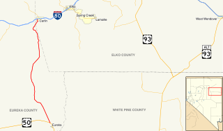
State Route 278 is a state highway in Nevada. It runs from U.S. Route 50 near Eureka north to Interstate 80 (I-80) in Carlin.
State Route 338 is a state highway in Lyon County, Nevada, United States. It connects the towns of Smith and Wellington to the California state line north of Bridgeport, California. Much of the route has served as a road through this section of Nevada since at least 1919, and was known as State Route 22 from the 1920s until the late 1970s.

State Route 67 is a primary state highway in the southwest part of the U.S. state of Virginia. It runs from State Route 80 near Honaker east to U.S. Route 460 at Raven, east concurrently with US 460 and U.S. Route 460 Business into downtown Richlands, and north to State Route 616 at Jewell Ridge on the Tazewell–Buchanan county line.
State Route 582 (SR 582) is a major 15.392-mile-long (24.771 km) highway in the Las Vegas Valley. The highway is the former route of U.S. Route 93 (US 93) and US 95 before they were moved to the current freeway alignment shared with Interstate 11 (I-11) and Interstate 515 (I-515). Known primarily as Boulder Highway, the route connects Downtown Las Vegas with Henderson and Boulder City to the southeast.
State Route 487 is a north–south state highway in White Pine County, Nevada. The route follows Baker Road from the Utah–Nevada state line southeast of Baker to U.S. Route 6 and U.S. Route 50. The route was previously known as State Route 73 prior to 1976. SR 487 is designated as a Nevada Scenic Byway.
State Route 488 is an east–west state highway in White Pine County, Nevada. The route covers Lehman Caves Road connecting the town of Baker to Great Basin National Park. The route existed as State Route 74 prior to 1976. SR 488 has been designated a Nevada Scenic Byway.
State Route 490 is a state highway in White Pine County, Nevada. The route serves a state prison north of Ely.

State Route 205 is a primary state highway in the U.S. state of Virginia. The state highway runs 18.47 miles (29.72 km) from SR 3 at Purkins Corner east to SR 3 at Oak Grove. SR 205 connects several small communities in eastern King George County and northwestern Westmoreland County. The state highway also passes through the Potomac River resort of Colonial Beach, where the highway has a spur, State Route 205Y.
U.S. Route 93 in the state of Arizona is a United States Numbered Highway that begins in Wickenburg and heads north to the Nevada state line at the Mike O'Callaghan–Pat Tillman Memorial Bridge.

U.S. Route 395 (US 395) is a United States Numbered Highway, stretching from Hesperia, California to the Canadian border in Laurier, Washington. The California portion of US 395 is a 557-mile (896 km) route which traverses from Interstate 15 in Hesperia, north to the Oregon state line in Modoc County near Goose Lake. The route clips into Nevada, serving the cities Carson City and Reno, before returning to California.
U.S. Route 6 is a transcontinental highway in the United States, stretching from Bishop, California, in the west to Provincetown, Massachusetts, on the east coast. The Nevada portion crosses the center of the state, serving the cities of Tonopah and Ely, en route to Utah and points further east. Like US 50, to the north, large desolate areas are traversed by the route, with few or no signs of civilization, and the highway crosses several large desert valleys separated by numerous mountain ranges towering over the valley floors, in what is known as the Basin and Range Province of the Great Basin.
State Route 486 was a state highway in White Pine County, Nevada. The roadway was turned over to local control in the 1990s.


