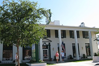
Boulder City is a city in Clark County, Nevada, United States. It is approximately 26 miles (42 km) southeast of Las Vegas. As of the 2010 census, the population of Boulder City was 15,023.

U.S. Route 93 (US 93) is a major north–south United States highway in the western United States. The southern terminus is at US 60 in Wickenburg, Arizona. The northern terminus is at the Canada–US border north of Eureka in Lincoln County, Montana, where the roadway continues into Roosville, British Columbia, as Highway 93. Major cities that US 93 travels through include: Las Vegas, Nevada; Twin Falls, Idaho; Missoula, Montana; and Kalispell, Montana.

U.S. Route 95 (US 95) is a north–south U.S. highway in the western United States. Unlike many other US highways, it has not seen deletion or replacement on most of its length by an encroaching Interstate highway corridor, due to its mostly rural course. Because of this, it still travels from border to border and is a primary north–south highway in both Nevada and Idaho. This is one of the few US Routes or Interstate highways to cross from Mexico to Canada.
Interstate 515 (I-515) is a 14.444-mile-long (23.245 km) spur route of Interstate 15 in Nevada that runs from the junction of I-11, I-215 and SR 564 in Henderson to the junction of I-15, US 93 and US 95 in Downtown Las Vegas. The freeway connects traffic headed from Boulder City and Henderson to Downtown Las Vegas via a direct, high-speed route and is concurrent with both US 93 and US 95 along its entire length.

U.S. Route 466 was an east–west United States highway. Though it reached a length of around 500 miles (805 km), the route was co-signed with other US routes for much of its length. When California deleted most of its U.S. Highways in the mid-1960s, including US 466 in 1964, there was no longer a need for the designation.
Interstate 11 (I-11) is an Interstate Highway that currently runs for 22.8 miles (36.7 km) on a predominantly northwest–southeast alignment in the U.S. state of Nevada, running concurrently with U.S. Route 93 (US 93) between the Arizona state line and Henderson. The freeway is tentatively planned to run from Nogales, Arizona, to the vicinity of Reno, Nevada, generally following the current routes of I-19, I-10, US 93 and US 95. Planners anticipate upgrading two existing highway segments to carry future I-11: US 93 in Arizona from Wickenburg to the Nevada state line on the Mike O'Callaghan–Pat Tillman Memorial Bridge over the Colorado River and US 95 in Nevada from the edge of the Las Vegas Valley to Tonopah. An exact alignment for I-11 has yet to be determined outside of these sections or through the Las Vegas Valley; however, a number of corridor alternatives have been identified for further study and refinement.

State Route 147 is a state highway serving the Las Vegas Valley in southern Nevada. It is signed as Lake Mead Boulevard and runs from Interstate 15 (I-15) and U.S. Route 93 in North Las Vegas east to the border of the Lake Mead National Recreation Area. It is not to be confused with Lake Mead Parkway, which also goes to Lake Mead but mainly runs in southern Las Vegas Valley and carries the designation of State Route 564.
State Route 589 (SR 589) comprised a large portion of Sahara Avenue, a major east–west section line road in the Las Vegas Valley. The road is named after the Sahara Hotel and Casino which is located on Las Vegas Boulevard where it intersects with Sahara Avenue.

State Route 165 is a state highway near the southern end of the U.S. state of Nevada. The road connects the town of Nelson to U.S. Route 95. The road originated in the 1940s and was one section of former State Route 60 until the 1970s.
Veterans Memorial Highway is the name chosen for the following roads:
Tropicana Avenue is a major east–west section line arterial in the Las Vegas area. The road is named after Tropicana Las Vegas which is located on the Las Vegas Boulevard where it intersects with Tropicana Avenue. Part of it is signed as Nevada State Route 593.
State Route 582 (SR 582) is a major 15.392-mile-long (24.771 km) highway in the Las Vegas Valley. The highway is the former route of U.S. Route 93 (US 93) and US 95 before they were moved to the current freeway alignment shared with Interstate 11 (I-11) and Interstate 515 (I-515). Known primarily as Boulder Highway, the route connects Downtown Las Vegas with Henderson and Boulder City to the southeast.
State Route 562 is an east–west highway in the Las Vegas Valley that comprises a portion of Sunset Road.
State Route 500 was a state highway located in Boulder City. It ran for about 2.25 miles (3.62 km) along the original route of US 93 and historical US 466 on the Nevada Highway through the middle of town. It came into being when the US 93 designation was moved to a new "truck bypass" alignment along the upper reaches of Hemenway Wash in 1982. After being turned over to local control by NDOT, the street was renamed as Nevada Way by the city.

U.S. Route 95 is a major U.S. highway traversing the U.S. state of Nevada from north to south directly through Las Vegas and providing connections to both Carson City and Reno. US 95 is cosigned with Interstate 80 for 95 miles (153 km) between a junction in Trinity and Winnemucca before heading north into Oregon at McDermitt.

In the U.S. state of Nevada, U.S. Route 93 is a major United States Highway traversing the eastern edge of the state. The highway connects the Las Vegas area to the Great Basin National Park, and provides further connections to Ely and Wells. US 93 also provides the majority of the most direct connection from the major metropolitan areas of Las Vegas and Phoenix to the Boise, Idaho Metropolitan Area with a final connection to Boise via Interstate 84 from Twin Falls, Idaho.
State Route 166 was a Nevada state highway that was signed along Lakeshore Road in Clark County. The road still runs along the west shore of Lake Mead, but is no longer a state highway.

Railroad Pass Hotel & Casino, named after nearby Railroad Pass, is a hotel and casino located in Henderson, Nevada.
State Route 173 is a state highway in Clark County, Nevada. The route provides access to downtown Boulder City from U.S. Route 95 (US 95) to the south. The route was originally part of US 95 until the highway was realigned following the completion of Interstate 11 (I-11) around Boulder City.
U.S. Route 93 Business is a business route of U.S. Route 93 (US 93) in Clark County, Nevada. The route provides access to Lake Mead and downtown Boulder City from Interstate 11 (I-11). The route was originally part of mainline US 93 before it was realigned around Boulder City along I-11.


