The Andes, Andes Mountains or Andean Mountain Range are the longest continental mountain range in the world, forming a continuous highland along the western edge of South America. The range is 8,900 km (5,530 mi) long, 200 to 700 km wide, and has an average height of about 4,000 m (13,123 ft). The Andes extend from north to south through seven South American countries: Venezuela, Colombia, Ecuador, Peru, Bolivia, Chile and Argentina.

Chimborazo is an inactive stratovolcano situated in the Cordillera Occidental range of the Andes. Its last known eruption is believed to have occurred around 550 A.D. Despite not being the tallest mountain in the Andes or on Earth, its summit holds the distinction of being the farthest point on Earth's surface from the Earth's center, due to its location along the planet's equatorial bulge. Chimborazo's height is 6,263 m, well below that of Mount Everest.

General Carrera Lake or Lake Buenos Aires is a deep lake located in Patagonia and shared by Argentina and Chile. Both names are internationally accepted, while the autochthonous name of the lake is Chelenko, which means "stormy waters" in Aonikenk. Another historical name is Coluguape from Mapuche, a derivative of this name is applied to Colhué Huapí Lake after Argentine explorer Francisco Moreno reached this lake in 1876 conflating it with Coluguape.

The Cordillera Oriental or Eastern Cordillera is a set of parallel mountain ranges of the Bolivian Andes, emplaced on the eastern and north eastern margin of the Andes. Large parts of Cordillera Oriental are forested and humid areas rich in agricultural and livestock products. Geologically, the Cordillera Oriental is formed by the Central Andean fold and thrust belt.

Laguna Verde is a salt lake in the Andes Mountains of Chile. It lies in the Atacama Region, near San Francisco Pass. The stratovolcano Ojos del Salado, on the border with Argentina, marks the south border of its basin.

The Nordenskjöld is a lake in Torres del Paine National Park in the Magallanes Region, southern Chile. The lake is named after the Swede Otto Nordenskiöld who discovered the lake in the beginning of the 20th century. The outfall of Nordenskjöld Lake consists of a waterfall known as Salto Grande. At this western end of the lake on the southern side is an abundance of wildlife including wild grazing guanaco.

Zapaleri is a volcano whose summit is the tripoint of the borders of Argentina, Bolivia and Chile. A number of railways are in the area. It is part of Potosí Department (Bolivia), Jujuy Province (Argentina), and Antofagasta Region (Chile). The volcano formed on top of the 2.89 mya Tara Ignimbrite from the Guacha caldera and the basement beneath the volcano is formed from Cretaceous and Tertiary rocks affected by tectonic deformation. Volcanic rocks are andesite, basalt, dacite and rhyolite. Late Cretaceous rocks are also found in the area, as are Pleistocene shoshonite volcanic rocks.
El Yeso is a reservoir located in the Andes, in the Santiago Metropolitan Region, Chile. It was formed by the damming of the Yeso River, part of the Maipo river basin. The reservoir has a capacity of 250,000,000 m³ and was completed in 1964.
Miño Volcano is a symmetrical cone-shaped stratovolcano located in El Loa Province, Antofagasta Region, Chile. It lies a few kilometres northwest of Aucanquilcha volcano and at its foot originates Loa River. The major settlement in its vicinity is Ollagüe. The volcano has erupted mafic andesite. Potassium-argon dating has yielded ages of 3.59±0.11 and 3.27±0.40 million years ago for Miño. This volcano is usually considered part of Aucanquilcha, and lava flows appear to originate from the summit.


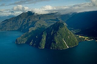
Monte Sarmiento is a pyramidal peak with a glaciated saddle-shaped summit located within Alberto de Agostini National Park, in the Chilean portion of Tierra del Fuego. It rises abruptly from the east shore of the Magdalena Channel and marks the western border of the Cordillera Darwin. The mountain is frequently shrouded in clouds, but when it is visible is "the most sublime spectacle in Tierra del Fuego" according to the words of Charles Darwin, one of the many people who have been captivated by the beauty of this mountain.
Magdalena Channel is a Chilean channel joining the Strait of Magellan with the Cockburn Channel and is part of a major navigation route which ultimately connects with the Beagle Channel. It separates Capitán Aracena Island from the westernmost portion of Isla Grande de Tierra del Fuego, and crosses Alberto de Agostini National Park. It is flanked by mountains, the chief of which is Monte Sarmiento. Like the Abra Channel and the Bárbara Channel farther west, it joins the western part of the Strait of Magellan directly to the Pacific Ocean.

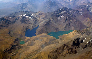
Bertrand Lake is a Chilean lake located in the Aysén del General Carlos Ibáñez del Campo Region. It is separated from Plomo Lake by a terminal moraine and is flanked on the west by the summits of the Cordón Contreras.

Italia Glacier is a tidewater glacier located in Alberto de Agostini National Park, Chile. It flows down in a southwest direction to its terminus in the Beagle Channel.
Reñihué Fjord is a fjord located at 42°30′59″S72°37′26″W, in Los Lagos Region of Chile. It opens into Gulf of Ancud and at its head, it receives the outflow of Reñihué Lake via the river of the same name. Its waters are navigated by a ferry serving a part of the route between Hornopirén and Caleta Gonzalo. The latter is a locality and cove located on the south shore of the fjord.

Salar de Chalviri, also known as Salar de Ohalviri, is a salt flat in the heart of Eduardo Avaroa Andean Fauna National Reserve, in the Sur Lípez Province, Potosí Department, in southwest Bolivia. It is located at an elevation of approximately 4,398 m (14,429 ft). Salvador Dalí Desert is located to the southwest of the salt flat.
Calzada is a mountain in the Andes, about 5,874 m (19,272 ft) high, located in the Cordillera Real of Bolivia. It lies in the La Paz Department, Larecaja Province, on the border of the Sorata Municipality and the Guanay Municipality. It is situated south-east of Ancohuma, between the mountain Q'asiri in the north-west and Chearoco in the south-east, and east of San Francisco Lake.

Pachatusan is a mountain northeast of the city of Cusco in the Andes of Peru, about 4,842 metres (15,886 ft) high. It is located in the Cusco Region, Calca Province, San Salvador District, in the Cusco Province, in the districts San Jerónimo and Saylla, and in the Quispicanchi Province, Oropesa District. It is situated on the western bank of the Vilcanota River, beside the mountain Huaypun in the south-east. Pachatusan lies above the sanctuary of San Salvador named Señor de Huanca.
Uma Jalanta is a mountain in the Cordillera Real in the Andes of Bolivia, about 5,723 metres (18,776 ft) high. It is located in the La Paz Department, Larecaja Province, Sorata Municipality. It lies south-east of the mountains Janq'u Uma and Janq'u Piti, near the mountain Misk'i T'ant'a.
Wiluyu Janq'u Uma or Wiluyu is a mountain in the Cordillera Real in the Andes of Bolivia, about 5,540 metres (18,176 ft) high. It is located in the La Paz Department, Larecaja Province, Sorata Municipality. It lies northwest of the mountain Yapuchañani, northeast of Misk'i T'ant'a and Uma Jalanta and east of Illampu.