Related Research Articles

Harrisburg is the capital city of the U.S. commonwealth of Pennsylvania and the seat of Dauphin County. With a population of 50,099 as of 2020, Harrisburg is the ninth-most populous city in Pennsylvania. It is the larger principal city of the Harrisburg–Carlisle metropolitan statistical area, also known as the Susquehanna Valley, which had a population of 591,712 in 2020 and is the fourth-most populous metro area in Pennsylvania. Harrisburg is situated on the east bank of the Susquehanna River and is located 83 miles (134 km) southwest of Allentown and 107 miles (172 km) northwest of Philadelphia.

Interstate 83 (I-83) is an Interstate Highway located in the states of Maryland and Pennsylvania in the Eastern United States. Its southern terminus is at a signalized intersection with Fayette Street in Baltimore, Maryland; its northern terminus is at I-81 near Harrisburg, Pennsylvania. I-83 runs from Downtown Baltimore north to I-695 near the northern suburb of Timonium on the Jones Falls Expressway before forming a concurrency with I-695. After splitting from I-695, the route follows the Baltimore–Harrisburg Expressway north to the border between Maryland and Pennsylvania. Upon crossing the state line, I-83 becomes the Veterans of Foreign Wars of the United States Memorial Highway and continues north through York toward the Harrisburg area. The route runs along the southern and eastern portion of the Capital Beltway that encircles Harrisburg before reaching its northern terminus.
East Pennsboro Township is a township in Cumberland County, Pennsylvania, United States. The population was 20,228 at the 2010 census, up from 18,254 at the 2000 census. East Pennsboro is the second most populous municipality in Cumberland County. The township is located along the western banks of the Susquehanna River, across from Harrisburg. There are many large corporations based in East Pennsboro Township that use the Camp Hill postal address, including the Rite Aid Corporation and Gannett Fleming.

Enola is a census-designated place (CDP) located along the Susquehanna River in East Pennsboro Township, Cumberland County, Pennsylvania, United States. The population was 6,111 at the 2010 census. Norfolk Southern operates Enola Yard, a large rail yard and locomotive shop in Enola. It is situated in Cumberland County, directly across the Susquehanna River from Harrisburg and is part of the Harrisburg–Carlisle metropolitan statistical area.

Lemoyne is a borough in Cumberland County, Pennsylvania, United States, which lies across the Susquehanna River from Harrisburg, Pennsylvania's capital. It is part of the Harrisburg–Carlisle metropolitan statistical area. Lemoyne was incorporated as a borough on May 23, 1905. As of the 2020 census, the borough population was 4,659. Lemoyne is served by Interstate 83 and U.S. Routes 11/15. Lemoyne is a part of the West Shore School District.

Lower Allen Township is a township in Cumberland County, Pennsylvania, United States. The population was 17,980 at the 2010 census.

Wormleysburg is a borough in Cumberland County, Pennsylvania, United States. The population was 3,070 at the 2010 census. It is part of the Harrisburg–Carlisle Metropolitan Statistical Area.

Lower Paxton is a township in Dauphin County, Pennsylvania, United States. The population was 53,501 at the 2020 census. It is the most populous municipality in Dauphin County and the 17th-most populated municipality in the state.
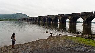
Susquehanna Township is a township in Dauphin County, Pennsylvania, United States. The population was 26,736 at the time of the 2020 census. This represents a 11.2% increase from the 2010 census count of 24,036. Susquehanna Township has the postal ZIP codes 17109 and 17110, which maintain the Harrisburg place name designation. The township is a suburb of Harrisburg and is connected to Marysville by the Rockville Bridge, the world's longest stone-arch rail bridge at the time of its completion.

Fairview Township is a township in York County, Pennsylvania, United States. The population was 17,436 at the 2020 census.

Blue Mountain, Blue Mountain Ridge, or the Blue Mountains of Pennsylvania is a ridge of the Appalachian Mountains in eastern Pennsylvania. Forming the southern and eastern edge of the Ridge-and-Valley Appalachians physiographic province in Pennsylvania, Blue Mountain extends 150 miles (240 km) from the Delaware Water Gap on the New Jersey border in the east to Big Gap in Franklin County in south-central Pennsylvania at its southwestern end.

Cumberland County is a county in the Commonwealth of Pennsylvania. As of the 2020 census, the population was 259,469. Its county seat is Carlisle. The county is part of the South Central Pennsylvania region of the state.

Capital City Airport is a public airport in Fairview Township, York County, Pennsylvania, three miles (5 km) southeast of Harrisburg, the capital of Pennsylvania.

Uptown is a section of Harrisburg, Pennsylvania located North of the Midtown and Downtown neighborhoods.

Downtown Harrisburg is the central core neighborhood, business and government center which surrounds the focal point of Market Square, and serves as the regional center for the greater metropolitan area of Harrisburg, Pennsylvania, United States.

Yellow Breeches Creek, also known as Callapatscink Creek, Callapatschink Creek or Shawnee Creek is a 56.1-mile-long (90.3 km) tributary of the Susquehanna River in central Pennsylvania, USA. There is no agreed upon explanation for the name Yellow Breeches Creek, which is found in land warrants as early as 1736.
Conodoguinet Creek is a 104-mile-long (167 km) tributary of the Susquehanna River in South central Pennsylvania in the United States. The name is Native American, and means "A Long Way with Many Bends".
The Eastern Distribution Center (EDC), located in New Cumberland, Pennsylvania, 3 miles (4.8 km) west of Harrisburg, is home to the largest distribution facility operated by the United States Department of Defense. It is managed by the Defense Logistics Agency (DLA) and is part of the Defense Distribution Depot Susquehanna (DDSP), which includes the operations of the nearby Naval Support Activity (NSA) in Mechanicsburg, Pennsylvania.

The Lebanon Valley is a geographic region that lies between South Mountain and the Ridge and Valley Province of eastern Pennsylvania. The valley lies almost entirely within Lebanon and Berks counties in Pennsylvania. Portions of the valley lie in eastern Dauphin and northern Lancaster counties in Pennsylvania. It is bound to its southwest by the Susquehanna River and to its northeast by the adjoining Lehigh Valley.
The West Shore of the Harrisburg area is a group of suburbs of Harrisburg, Pennsylvania which are located to the west of the Susquehanna River. The Susquehanna River is very wide near Harrisburg, and that contributes to the perception, at least among the local inhabitants, that the East Shore and West Shore have distinct identities. The West Shore area includes parts of eastern Cumberland County, southeastern Perry County and northern York County.
References
- ↑ "New Cumberland Defense Depot Susquehanna Pennsylvania (DDSP)" . Retrieved February 21, 2012.