
New Georgia is a township in Montserrado County, Liberia [1] that was first settled by Africans who had been taken from slave ships that were seized or wrecked near the United States, then sent to Liberia after several years had passed.
New Georgia is a township in Montserrado County, Liberia [1] that was first settled by Africans who had been taken from slave ships that were seized or wrecked near the United States, then sent to Liberia after several years had passed.
In July 1827 a ship named Norfolk carried 131, [2] 143 [3] or 144 [4] Africans to Liberia from the United States, of whom 78 were adult women and another eleven or twelve were under ten years of age. [5] One hundred twenty of those people had been found on the slave ship Antelope when it was seized off the coast of Florida in 1820. [6] They had been held in Georgia for seven years waiting for the courts to settle their fate. [7] After being kept under supervision in Monrovia for a while, the people from the Antelope were settled along Stockton Creek on Bushrod Island about four miles up the Mesurado River from Monrovia. [8] The settlement was named New Georgia after their home of the prior seven years. [9] Although "recaptured" Africans (people taken from slave ships by U.S. Navy anti-slave trade patrol ships) had been brought to Liberia previously, none were still there when the people from the Antelope arrived. Most, if not all, of the people found on the Antelope in 1820 and taken to Liberia in 1827 had originally been loaded on slave ships at Cabinda, and were probably Kongo people. [10]
In March 1830 92 African men who had survived the 1827 wreck of the slave ship Guerrero near Key Largo, Florida were brought to Liberia from the United States and settled at New Georgia. These men were mostly Igbos and "Persas" or "Pessas". [11] About 150 people who had been freed from coastal slaving stations by Americo-Liberians also settled in New Georgia. [12]
In the 1830s New Georgia consisted of separate communities of Congos and Igbos separated by a small rivulet, with a total of about 300 people. The "recaptured" Africans at New Georgia had inter-married between the groups and many of the men married women from local tribes. There was a schoolhouse for the children, and the town was described as being pleasing in appearance. Houses in New Georgia were surrounded by vegetable and fruit gardens and the town was surrounded by fields where maize, rice, cassava and vegetables were grown. New Georgia was an important supplier to the market in Monrovia. The men of the town also sawed lumber and made shingles. [13] The people of New Georgia prospered, and were described as "decidedly the most contented and independent of any in the colony." [14] New Georgia is listed as one of the settlements making up the Commonwealth of Liberia in the 1839 Constitution. [15] In 1878 a traveler reported about 500 people living in New Georgia. [16]
As of 2009 a bridge connecting New Georgia with Barnersville was under construction. The new bridge would replace one that was built in 1992 for military purposes by peacekeepers from the Economic Community of West African States Monitoring Group. The badly deteriorated bridge had been closed to vehicle traffic for several years before it collapsed in 2009. [17] Also as of 2009 a new elementary school operated by the United Methodist Church was under construction in New Georgia. [18]
New Georgia (or Zone Z1300) is divided into eleven communities;
| Community | Inhabitants (2014 est.) | No. of Households (2014 est.) |
|---|---|---|
| Bassa Town | 2,524 | 616 |
| Battery Factory | 4,869 | 1,188 |
| Chocolate City A | 5,961 | 1,454 |
| Chocolate City B | 6,025 | 1,470 |
| Flahn Town | 5,417 | 1,321 |
| Iron Factory | 3,966 | 967 |
| New Georgia | 5,700 | 1,390 |
| New Georgia Estate | 9,753 | 2,379 |
| Old Field Gulf Sign Board | 9,739 | 2,375 |
| SOS Transit | 5,877 | 1,433 |
| Topoe Village | 6,345 | 1,548 |
| Total: | 66,176 | 16,141 |
In 2018 President George Weah appointed Lewis K. Wleh, Sr. as Commissioner for New Georgia. [21]
New Georgia is part of the Montserrado-13 electoral district. [19]

Liberia, officially the Republic of Liberia, is a country on the West African coast. It is bordered by Sierra Leone to its northwest, Guinea to its north, Ivory Coast to its east, and the Atlantic Ocean to its south and southwest. It has a population of around 5.5 million and covers an area of 43,000 square miles (111,369 km2). The official language is English. Over 20 indigenous languages are spoken, reflecting the country's ethnic and cultural diversity. The capital and largest city is Monrovia.

Liberia is a country in West Africa founded by free people of color from the United States. The emigration of African Americans, both freeborn and recently emancipated, was funded and organized by the American Colonization Society (ACS). The mortality rate of these settlers was the highest among settlements reported with modern recordkeeping. Of the 4,571 emigrants who arrived in Liberia between 1820 and 1843, only 1,819 survived (39.8%).

Monrovia is the administrative capital and largest city of Liberia. Founded in 1822, it is located on Cape Mesurado on the Atlantic coast and as of the 2022 census had 1,761,032 residents, home to 33.5% of Liberia’s total population. Its largely urbanized metro area, including Montserrado and Margibi counties, was home to 2,225,911 inhabitants as of the 2022 census.

Montserrado County is a county in the northwestern portion of the West African nation of Liberia containing its national capital, Monrovia. One of 15 counties that comprise the first-level of administrative division in the nation, it has 17 sub political districts. As of the 2022 Census, it had a population of 1,920,914, making it the most populous county in Liberia. The area of the county measures 738.5 square miles (1,913 km2), the smallest in the country. Bensonville serves as the capital.

George Tawlon Manneh Oppong Ousman Weah is a Liberian politician and former professional footballer who served as the 25th president of Liberia from 2018 to 2024. Before his election for the presidency, Weah served as senator from Montserrado County. He played as a striker in his prolific 18-year professional football career which ended in 2003. Weah is the first African former professional footballer to become a head of state, and the only African Ballon d’Or and FIFA World Player of the Year winner in history, winning both awards in 1995. He won the African Footballer of the Year 3 times and is widely considered one of the greatest strikers of all time.

The Kru, Krao, Kroo, or Krou are a West African ethnic group who are indigenous to western Ivory Coast and eastern Liberia. European and American writers often called Kru men who enlisted as sailors or mariners Krumen. They migrated and settled along various points of the West African coast, notably Freetown, Sierra Leone, but also the Ivorian and Nigerian coasts. The Kru-speaking people are a large ethnic group that is made up of several sub-ethnic groups in Liberia and Ivory Coast. In Liberia, there are 48 sub-sections of Kru tribes, including the Jlao Kru. These tribes include Bété, Bassa, Krumen, Guéré, Grebo, Klao/Krao, Dida, Krahn people and Jabo people.

Cape Mesurado, also called Cape Montserrado, is a headland on the coast of Liberia near the capital Monrovia and the mouth of the Saint Paul River. It was named Cape Mesurado by Portuguese sailors in the 1560s. It is the promontory on which African-American settlers established the city now called Monrovia on 25 April 1822.
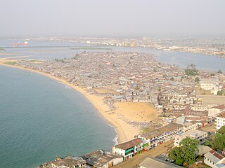
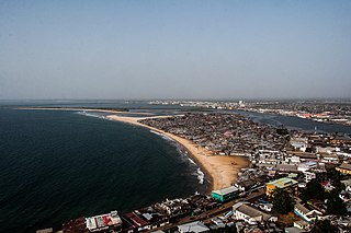
Bushrod Island is an island near Monrovia, Liberia surrounded by the Atlantic Ocean, the Saint Paul River, the Mesurado River and Stockton Creek. It contains the Freeport of Monrovia, the major national port of Liberia and a variety of businesses. It also contains numerous residential areas and government buildings. There are four towns on the island, Vai Town, New Kru Town, Logan Town and Clara Town.
West Point is a township of the Liberian capital city of Monrovia, located on a 0.53 km2 peninsula which juts out into the Atlantic Ocean between the Mesurado and Saint Paul rivers. West Point is one of Monrovia's most densely populated slums.
Arthington is a small town in Montserrado County, Liberia, located along the Saint Paul River northeast of the capital city of Monrovia. It is mainly known as the hometown of former President Charles Taylor, the country's 22nd president.

Clay-Ashland is a township located 10 miles (16 km) from the capital city of Monrovia in Liberia. The town is in the St. Paul River District of Montserrado County. It is named after Henry Clay — a slaveowner and American Colonization Society co-founder who favored gradual emancipation — and his estate Ashland in Lexington, Kentucky.
Careysburg is a city in Montserrado County, Liberia. It was founded in 1856, and is named in honor of Rev. Lott Carey, the first American Baptist missionary to Africa and a key figure in the founding of the Colony of Liberia. It is located 15 miles northeast of Monrovia.
Caldwell is a township located in Montserrado County, Liberia. Caldwell was one of the four townships established in the first wave of colonization. It is listed as one of the original settlements comprising the Commonwealth of Liberia in the 1839 Constitution, which was drafted by the American Colonization Society. The name comes from Elias B. Caldwell and family, about 1816, Presbyterians in what became Caldwell, New Jersey.
Guerrero was a Spanish slave ship that wrecked in 1827 on a reef near the Florida Keys with 561 Africans aboard. Forty-one of the Africans drowned in the wreck. Guerrero had been engaged in a battle with a British anti-slavery patrol ship, HMS Nimble, stationed on the northern approaches to Cuba. Nimble also ran onto the reef, but was refloated and returned to service. The two ships were attended by wreckers, who rescued the Spanish crew and surviving Africans from their ship and helped refloat Nimble. Spanish crew members hijacked two of the wrecking vessels and took almost 400 Africans to Cuba, where they were sold as slaves. Most of the remaining Africans were eventually returned to Africa.
Antelope was a slave ship that the United States captured in 1820 with more than 280 captive Africans aboard. It had been legally engaged in the African slave trade under the flag of Spain when it was taken over by a privateer at Cabinda. The legal case on the fate of the captured Africans, known as The Antelope, lasted for seven years, with some of the Africans being turned over as slaves to Spanish owners, while 120 were sent as free people to Liberia. Both the commandeering of the boat, as well as the ensuing trial, are the subject of the book Dark Places of the Earth, by Jonathan M. Bryant.
The Antelope, 23 U.S. 66 (1825), was a case in which the Supreme Court of the United States considered, for the first time, the legitimacy of the international slave trade, and determined "that possession on board of a vessel was evidence of property".
New Kru Town is a northwestern coastal suburb of Monrovia, Liberia.

Americo-Liberian people, are a Liberian ethnic group of African American, Afro-Caribbean, and liberated African origin. Americo-Liberians trace their ancestry to free-born and formerly enslaved African Americans who emigrated in the 19th century to become the founders of the state of Liberia. They identified themselves as Americo-Liberians.
The following is a timeline of the history of the city of Monrovia, Liberia.
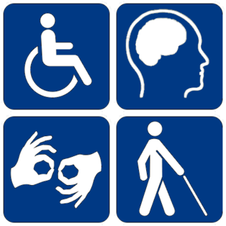
The National Commission on Disabilities (NCD) is the Autonomous Agency established in Liberia by an Act of Legislation on November 23, 2005, and printed into Handbill by the Ministry of Foreign Affairs December 29, 2005.