New Henniker Bridge

Last updated
New Henniker Bridge
New Bridge

Historical American Buildings Survey L. C. Durette, Photographer May 15, 1936. VIEW LOOKING NORTH WEST - Covered Bridge, Spanning Contoocook River, Hopkinton, Merrimack County, NH HABS NH,7-HOP.V,2-1.tif

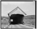
View looking north west - Covered Bridge, Spanning Contoocook River, Hopkinton, NH
Coordinates 43°10′54″N71°45′07″W / 43.181700°N 71.751880°W / 43.181700; -71.751880 Coordinates: 43°10′54″N71°45′07″W / 43.181700°N 71.751880°W / 43.181700; -71.751880
Crosses Contoocook River
Named for New road to Henniker, New Hampshire
Owner Town of Hopkinton
Historic American Buildings Survey HABS NH-30
Website https://www.loc.gov/pictures/item/nh0143/
Preceded by Stone arch bridge washed away in 1852
Followed by Steel truss bridge just north of it which is no longer in existence
Characteristics
Design Briggs Truss
Material Stone piers
Trough construction Wood lattice and arch
Total length 180 ft.
Width 20 ft.
Height 22 ft.
No. of spans 1
History
Constructed by John C. Briggs
Construction start 1863
Construction cost $2,500
Rebuilt 1935
Closed 1936

New Henniker Bridge or New Bridge was a covered bridge in West Hopkinton, New Hampshire, which carried Henniker Road over the Contoocook River. The truss bridge was completed in 1863, and was the second bridge on the site. The original stone arch bridge was built in 1845 and was washed away by flood in 1852. The bridge was just over 20 feet (6.1 m) wide and 180 feet (55 m) long, and consisted of a single span supported by two triple lattice trusses resting on granite abutments. The patent drawings show an all-timber truss with fixed intersection angles in the center of the span. At the ends of the span the angles of the diagonals vary. The end post is vertical, and each brace further from it is sloped a little more. [1] [2]

Covered bridge wooden bridge with protective cover

A covered bridge is a timber-truss bridge with a roof, decking, and siding, which in most covered bridges, create an almost complete enclosure. The purpose of the covering is to protect the wooden structural members from the weather. Uncovered wooden bridges typically have a lifespan of only 20 years because of the effects of rain and sun, but a covered bridge could last 100 years.

West Hopkinton, New Hampshire Populated place in New Hampshire, United States

West Hopkinton is a populated place within the town of Hopkinton in Merrimack County, New Hampshire, United States. West Hopkinton is well known for its agricultural center, preservation of historical landmarks and recreational activities within the village.

Contoocook River river in the United States of America

The Contoocook River is a 71-mile-long (114 km) river in New Hampshire. It flows from Pool Pond and Contoocook Lake on the Jaffrey/Rindge border to Penacook, where it empties into the Merrimack River. It is one of only a few rivers in New Hampshire that flow in a predominantly northward direction. Three covered bridges span the river, one in the village of Contoocook in the town of Hopkinton, one in the town of Henniker, and a third on the Hancock-Greenfield line. Residents and tourists have made the Contoocook popular for fishing and whitewater boating.

In 1935 the bridge had sustained damage during a flood and was repaired. The bridge was utilized until 1936 when a steel truss bridge was built adjoining it to the north and ready for traffic. The covered bridge was then destroyed. [3]

Flood Overflow of water that submerges land that is not normally submerged

A flood is an overflow of water that submerges land that is usually dry. In the sense of "flowing water", the word may also be applied to the inflow of the tide. Floods are an area of study of the discipline hydrology and are of significant concern in agriculture, civil engineering and public health.

Related Research Articles

Hunseckers Mill Covered Bridge

The Hunsecker's Mill Covered Bridge is a covered bridge located in Lancaster County, Pennsylvania, United States. The bridge has a single span, wooden, double Burr arch trusses design. The bridge, which spans the Conestoga River, is 180 feet (55 m) long, making it the longest single span covered bridge in the county.

Truss bridge bridge whose load-bearing superstructure is composed of a truss

A truss bridge is a bridge whose load-bearing superstructure is composed of a truss, a structure of connected elements usually forming triangular units. The connected elements may be stressed from tension, compression, or sometimes both in response to dynamic loads. Truss bridges are one of the oldest types of modern bridges. The basic types of truss bridges shown in this article have simple designs which could be easily analyzed by 19th and early 20th-century engineers. A truss bridge is economical to construct because it uses materials efficiently.

Farmington River river in the United States of America

The Farmington River is a river, 46.7 miles (75.2 km) in length along its main stem, which is located in northwest Connecticut with major tributaries extending into southwest Massachusetts. Via its longest branch, the Farmington's length increases to 80.4 miles (129.4 km), making it the Connecticut River's longest tributary by a mere 2.3 miles (3.7 km) over the major river directly to its north, the Westfield River. The Farmington River's watershed covers 609 square miles (1,580 km2). The river historically played an important role in small-scale manufacturing in towns along its course, but it is now mainly used for recreation and drinking water. The Farmington River Watershed Association is a non-profit organization for conservation and preservation of this river.

Columbia Bridge (Connecticut River)

The Columbia Bridge is a covered bridge, carrying Columbia Bridge Road over the Connecticut River between Columbia, New Hampshire and Lemington, Vermont. Built in 1911-12, it is one of only two New Hampshire bridges built with Howe trusses, and is one of the last covered bridges built in the historic era of covered bridge construction in both states. It was listed on the National Register of Historic Places in 1976.

Mount Orne Covered Bridge bridge in United States of America

The Mount Orne Bridge is a covered bridge over the Connecticut River between Lancaster, New Hampshire, and Lunenburg, Vermont. It joins Elm Street in South Lancaster with River Road in Lunenburg. Built in 1911, it is one of two Howe truss bridges across the Connecticut River. It was listed on the National Register of Historic Places in 1976.

Old Blenheim Bridge Wooden covered bridge that spanned Schoharie Creek in North Blenheim, New York, United States

Old Blenheim Bridge was a wooden covered bridge that spanned Schoharie Creek in North Blenheim, New York, United States. With an open span of 210 feet (64 m), it had the longest span of any surviving single-span covered bridge in the world. The Bridgeport Covered Bridge in Nevada County, California, is longer overall at 233 feet (71 m) but is argued to have a 208 feet (63 m) clear span. The bridge, opened in 1855, was also one of the oldest of its type in the United States. It was destroyed by flooding resulting from Tropical Storm Irene in 2011. Rebuilding of the bridge commenced in 2017 and was completed in 2018.

West Union Covered Bridge (Indiana) place in Indiana listed on National Register of Historic Places

The West Union Covered Bridge is north-northeast of Montezuma, Indiana. The two-span Burr Arch Truss covered bridge structure was built by Joseph J. Daniels in 1876. It is notable for being the longest standing covered bridge in Parke County, and one of the nation's best-preserved examples of the Burr truss.

Wilkins Mill Covered Bridge place in Indiana listed on National Register of Historic Places

The Wilkins Mill Covered Bridge is north of Rockville, Indiana. The single span Burr Arch Truss covered bridge structure was built by William Hendricks in 1906. The bridge is 120 feet (37 m) long, 16 feet (4.9 m) wide, and 13 feet (4.0 m) high.

B & O Railroad Potomac River Crossing

The Baltimore and Ohio Railroad Crossings at the Potomac River are a set of railroad bridges that span the Potomac River between Maryland Heights, Maryland and Harpers Ferry, West Virginia in the United States.

West Cornwall Covered Bridge

The West Cornwall Covered Bridge is a wooden covered lattice truss bridge carrying the Sharon-Goshen Turnpike over the Housatonic River in the town of Cornwall, Connecticut. Records indicate that a bridge may have been in place in this location as early as 1762. A previous bridge was destroyed in the flood of 1837 and a new bridge was constructed in 1841. This bridge would also be destroyed and the current bridge would be completed circa 1864. Utilizing the central pier from the previous incarnation, despite the Town lattice being able to withstand the weight and single span, the bridge has two spans. The later addition of queen trusses and supports gives the bridge an unusual appearance. Modernization of the bridge in 1968 and 1973 has continued to let the bridge handle traffic. It was added to the National Register of Historic Places in 1975.

Whittier Bridge

The Whittier Bridge is a historic wooden covered bridge in Ossipee, New Hampshire. The bridge carried an old alignment of New Hampshire Route 25 over the Bearcamp River. Built in 1870, it is one of New Hampshire's few surviving 19th-century covered bridges, and a rare example of a Paddleford truss. The bridge was listed on the National Register of Historic Places in 1984. It was closed to vehicular traffic in 1989, and was removed from its footings for restoration in 2008. It is presently resting on Nudd Road adjacent to the crossing point.

Watson Settlement Bridge

Watson Settlement Bridge is a historic covered bridge in eastern Littleton, Maine, United States. Built in 1911, it is one of the youngest of Maine's few surviving covered bridges. It formerly carried Framingham Road over the Meduxnekeag River, but is now closed to traffic, the road passing over a modern bridge to its south. It was listed on the National Register of Historic Places in 1970.

Swiftwater Covered Bridge

The Swiftwater Covered Bridge is a historic covered bridge which carries Porter Road over the Wild Ammonoosuc River in Bath, New Hampshire. Built in 1849, it is one of New Hampshire's few surviving 19th-century covered bridges, and a well-preserved example of the Paddleford truss design. The bridge was added to the National Register of Historic Places in 1976.

Bartrams Covered Bridge

Bartram's Covered Bridge, a historic covered bridge built in 1860, uses a Burr Truss design and carried Goshen Road over Crum Creek on the border between Delaware County and Chester County, Pennsylvania. It is 30 feet (9.1 m) long and 13 feet (4.0 m) wide and is the only covered bridge remaining of the 30 which once stood in Delaware County. The bridge has slanted planks at each entrance and is the only covered bridge in Pennsylvania with this feature. According to an on-site marker from the Newtown Square Historical Preservation Society, the bridge was built to be "hi and wide as a load of hay" It was built by Ferdinand Wood and named for Mordecai Bartram.

Capon Lake Whipple Truss Bridge bridge in West Virginia

The Capon Lake Whipple Truss Bridge, formerly known as South Branch Bridge or Romney Bridge, is a historic Whipple truss bridge in Capon Lake, West Virginia. It is located off Carpers Pike and crosses the Cacapon River. The bridge formerly carried Capon Springs Road over the river, connecting Capon Springs and Capon Lake.

Durgin Bridge

The Durgin Bridge is a covered bridge carrying Durgin Bridge Road over the Cold River in eastern Sandwich, New Hampshire. Built in 1869, it is a rare surviving example of a Paddleford truss bridge, and one of the few surviving 19th-century covered bridges in New Hampshire. It was listed on the National Register of Historic Places in 1983.

Goffstown Covered Railroad Bridge

The Goffstown Covered Railroad Bridge was a rare railroad covered bridge in Goffstown, New Hampshire. It was built in 1901 by the Boston and Maine Railroad, on the site of an earlier bridge built in 1850 by the New Hampshire Central Railroad, and carried its tracks across the Piscataquog River in the center of Goffstown. The bridge was listed on the National Register of Historic Places in 1975, and destroyed by arson in 1976.

Thomas Creek (Linn County, Oregon) stream in Linn County in the U.S. state of Oregon

Thomas Creek is a stream, about 35 miles (56 km) long, in Linn County in the U.S. state of Oregon. Beginning in Willamette National Forest on the western slopes of the Cascade Range, the creek flows generally west through Santiam State Forest and farmland to meet the South Santiam River west of Scio.

South Newfane Bridge bridge in United States of America

The South Newfane Bridge is a historic bridge, carrying Parish Hill Road across the Rock River in the village of South Newfane, Vermont. It is a Pratt through truss span, manufactured from rolled I-beams in 1939 to replace a bridge washed away in flooding. It was listed on the National Register of Historic Places in 1992.

Woodstock Warren Through Truss Bridge

The Woodstock Warren Through Truss Bridge was a historic iron bridge that carried Bridges Road across the Ottauquechee River in western Woodstock, Vermont. The bridge was built in 1925, and was a rare example of the state of a double-intersection Warren through truss. The bridge was swept away by flooding caused by Hurricane Irene in 2011; it was listed on the National Register of Historic Places in 1992.

References

  1. "Henniker Road Covered Bridge 29-07-62x". Dave King, Will Truax. 9 April 2014. Retrieved 16 December 2015.
  2. "Henniker Road, Merrimack County" . Retrieved 16 December 2015.
  3. "HABS NH-30" (PDF). Eugene W. Clark. Historic American Buildings Survey. December 1937. Retrieved 16 December 2015.