
The Native Sons of the Golden West (NSGW) is a fraternal service organization founded in the U.S. state of California in 1875, dedicated to historic preservation and documentation of the state's historic structures and places, the placement of historic plaques, and other charitable functions in California. In 1890 the organization placed California's first marker honoring the discovery of gold, which gave rise to the state nickname, "The Golden State". U.S. President Richard M. Nixon and Chief Justice Earl Warren served terms as presidents of the NSGW.
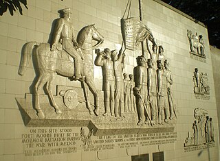
The Mormon Battalion was the only religious unit in United States military history in federal service, recruited solely from one religious body and having a religious title as the unit designation. The volunteers served from July 1846 to July 1847 during the Mexican–American War of 1846–1848. The battalion was a volunteer unit of between 534 and 559 Latter-day Saint men, led by Mormon company officers commanded by regular U.S. Army officers. During its service, the battalion made a grueling march of nearly 2,100 miles from Council Bluffs, Iowa, to San Diego, California.
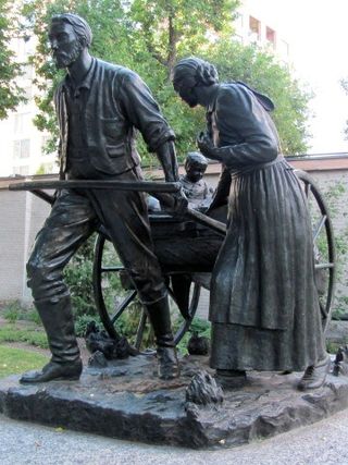
The Mormon pioneers were members of the Church of Jesus Christ of Latter-day Saints, also known as Latter-day Saints, who migrated beginning in the mid-1840s until the late-1860s across the United States from the Midwest to the Salt Lake Valley in what is today the U.S. state of Utah. At the time of the planning of the exodus in 1846, the territory was part of the Republic of Mexico, with which the U.S. soon went to war over a border dispute left unresolved after the annexation of Texas. The Salt Lake Valley became American territory as a result of this war.


The Stanislaus River is a tributary of the San Joaquin River in north-central California in the United States. The main stem of the river is 96 miles (154 km) long, and measured to its furthest headwaters it is about 150 miles (240 km) long. Originating as three forks in the high Sierra Nevada, the river flows generally southwest through the agricultural San Joaquin Valley to join the San Joaquin south of Manteca, draining parts of five California counties. The Stanislaus is known for its swift rapids and scenic canyons in the upper reaches, and is heavily used for irrigation, hydroelectricity and domestic water supply.

The Church of Jesus Christ of Latter-day Saints in California refers to the Church of Jesus Christ of Latter-day Saints and its members in California. California has the 2nd most members of the LDS Church in the United States, behind Utah. The LDS Church is the 2nd largest denomination in California, behind the Roman Catholic Church.
Atlanta is an unincorporated community located in San Joaquin County, California. Its elevation is 62 ft and is located at 37°48′47″N121°07′15″W.

San Joaquin City is a former settlement in San Joaquin County, California. It was established in 1849, during the California Gold Rush. It was located on the west bank of the San Joaquin River just below the point where Airport Way crosses the river today. It was an important settlement along the old River Road between Banta and Grayson's Ferry (now the community of Grayson in Stanislaus County.

Glen Helen Regional Park is a county park located in San Bernardino, California, United States adjacent to the Cajon Pass. It was the site of both US Festivals of the early 1980s. It is also home to the Glen Helen Amphitheater, the largest outdoor amphitheater in the United States. The park also hosts several off-road races since 1985.

For the 1969 monument in San Diego, California, see Mormon Battalion Monument.

Fort Benson was a Fort built in 1856 in present-day Colton in San Bernardino County, California. The Fort is named for its builder, Jerome Benson. The Fort was abandoned a year after it was built in 1857. Fort Benson was designated a California Historic Landmark (No.617) on September 11, 1957. Jerome Benson, in fear, built the Fort because of land disputes. The fort on his land claim, was made of earthworks and wood. The fort was defended by a brass cannon. The fort was used only one year as about half the Mormons around his land were told to return to Utah during the Mormon War, also call the Utah War. On December 27, 1858, the US Army arrived into San Bernardino. The US Army's Mojave Expedition leader was Colonel William Hoffman. He placed troops in San Bernardino and Cajon Pass to deal with Indians and the land problems. Fort Benson is gone and only a marker is at the spot of the fort.

The Santa Fe And Salt Lake Trail Monument was designated a California Historic Landmark (No.576) on May 17, 1957. Santa Fe And Salt Lake Trail Monument marks the place two Historic trail merged in Cajon Pass in San Bernardino County, California. The Old Spanish Trail and the Mohave Trail-Mojave Road merged in Cajon Pass. The large white marker is just off the Interstate 15 in Cajon Pass, was U.S. Route 66 in the past. It was built by the Pioneer Society of San Bernardino to remember and honor the pioneers that came west. The marker is 12 feet tall and 7 feet square at the base. Cajon Pass was home to the Serrano Indian, Native Californians that lived in the nearby Atongaibit village, in what is now Hesperia.

The Mormon Trail Monument was designated a California Historic Landmark (No.577). The Monument is to remember the 500 Mormon pioneers came to the San Bernardino Valley in June 1851. The Monument is near Phelan, California in San Bernardino County, California. The Monument was built in 1937 and is on California State Route 138, 3.6 Miles West of Interstate 15. In 1857 about half the Mormons were told to return to Utah during the Mormon War, also call the Utah War. the Mormon War, or the Mormon Rebellion
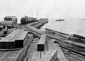
The place of McFadden Wharf was designated a California Historic Landmark (No.794) on July 3, 1964.

The Gates of Anaheim are a series of gates in California that mark the historic entrance to Anaheim, California. Four city gates were built: North, East, South, and West. They were designated a California Historic Landmark (No.122) on March 29, 1933.

The ship Brooklyn Saints were pioneers who sailed from New York to California to establish the first Mormon colony in the West. Due to religious persecution, leaders of the Church of Jesus Christ of Latter-day Saints planned to relocate the Mormon populace outside the United States. Two hundred thirty eight pioneers were recruited to sail around Cape Horn with heavy equipment for a large colony. They would plant crops and build infrastructure to receive the larger migration coming west by wagon the following year. Brooklyn took six months to sail 24,000 miles around Cape Horn to Alta California, surviving two terrible storms. Upon landing, the Brooklyn Saints were instrumental in building San Francisco and helped to kick off the California Gold Rush.

Fort Stockton, later called Fort Dupont was a historical fortress in San Diego, California built in 1828. The Fort Stockton site is a California Historical Landmark No. 54, listed on December 6, 1932.
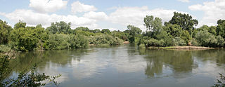
Battle of Stanislaus site is a historical site in Manteca, California in San Joaquin County. The Battle of Stanislaus site is a California Historical Landmark No. 214 listed on June 20, 1935. The Battle of Stanislaus was fought in 1829 on the North bank of the of Stanislaus River, near the meeting of the San Joaquin River and Stanislaus River. The Governor of California, José María de Echeandía, ordered Mariano Guadalupe Vallejo to attacked the Cosumnes tribe, a Miwok, Yokuts and Nisenan people group. Cosumnes has earlier raided local ranches in the area. The fight was one of a number of battles fought at the time in the San Joaquin Valley. The war between the tribes and First Mexican Republic in Alta California did not end due to a war end, but by a mosquito-borne disease, malaria. Malaria can into the San Joaquin Valley in 1833 by Canadian beaver trappers with the Hudson's Bay Company. Over 20,000 California natives died from malaria in 1833. The Battle of Stanislaus was the last of the California Northern tribal wars. The war The Mexican army used cannons to fight the last of these wars.

Juan Brown (1799-1859), nickname Juan Flaco, known as the Paul Revere of California, rode from Los Angeles to San Francisco California in four days, 52 hours, in 1846, during the Mexican–American War. Juan "Flaco" Brown was send by Captain Archibald H. Gillespie at Fort Hill to due the Siege of Los Angeles, started on September 22, 1846. United States Army Troops were trapped in Pueblo de Los Ángeles, Alta California by José María Flores men. Juan "Flaco" Brown took word to Commodore Robert F. Stockton in San Francisco of the serious trouble the Gillespie's troops in Los Angeles were in.

Weber Point Home is a historical site in Stockton, California in San Joaquin County. The site of the former Weber Point Home is a California Historical Landmark No. 165, listed on January 11, 1935. The Weber Point Home was a built by Captain Charles M. Weber founder of Stockton. Weber was pioneer of California and built a two-story adobe-and-redwood house in 1850. At the time it was the largest house in Stockton. The house was built on the east end of the Stockton Channel. The house was surrounded by landscaped gardens built for his new wife Helen Murphy. Weber lived in the house till his death in 1881. The house was located on Center Street between Channel and Miner Street in Stockton. The Weber Point House was destroyed in a fire in 1917. The Weber Point House was the center of the 8,747 acre Mexican land grant Rancho Campo de los Franceses. The Rancho owned present day Stockton and lands south and east, most of the current San Joaquin County.

