New pedestrianism

Last updated
Suburban design compared to New Urbanism and New Pedestrianism. New Pedestrianism compared to New Urbanism and suburban design.jpg
Suburban design compared to New Urbanism and New Pedestrianism.
New Pedestrianism Street Plan by Michael E. Arth New Pedestrianism Street Plan by Michael E. Arth.jpg
New Pedestrianism Street Plan by Michael E. Arth
Example of New Pedestrianism: Proposed pedestrian village, showing streets in rear and pedestrian lanes in front Palmetto Springs pedestrian village.png
Example of New Pedestrianism: Proposed pedestrian village, showing streets in rear and pedestrian lanes in front
Example of rather typical suburban street in the United States: wide, built for cars, with front-loading garages that dominate the front of the house (Austin, TX 2008). Typical suburban street in the United States.tif
Example of rather typical suburban street in the United States: wide, built for cars, with front-loading garages that dominate the front of the house (Austin, TX 2008).
Example of New Urbanism where cars and pedestrians are both provided for in a street in the renewed city center of Radovish, North Macedonia. Centre of Radovish.jpg
Example of New Urbanism where cars and pedestrians are both provided for in a street in the renewed city center of Radovish, North Macedonia.

New Pedestrianism (NP) is a more pedestrian and ecology-oriented variation of New Urbanism in urban planning theory, founded in 1999 by Michael E. Arth, an American artist, urban/home/landscape designer, futurist, and author. NP addresses the problems associated with New Urbanism and is an attempt to solve various social, health, energy, economic, aesthetic, and environmental problems, with special focus on reducing the role of the automobile. [1] [2] [3] A neighborhood or new town utilizing NP is called a Pedestrian Village. Pedestrian Villages can range from being nearly car-free to having automobile access behind nearly every house and business, but pedestrian lanes are always in front. [4] [5] [6]

New Urbanism urban design movement promoting environmentally friendly habits

New Urbanism is an urban design movement which promotes environmentally friendly habits by creating walkable neighborhoods containing a wide range of housing and job types. It arose in the United States in the early 1980s, and has gradually influenced many aspects of real estate development, urban planning, and municipal land-use strategies.

Michael E. Arth American artist

Michael E. Arth is an American polymath and author with expertise in public policy, politics, futurism, architecture, landscape design, urban design, construction, fine art, photography, and filmmaking.

Contents

To a large extent New Urbanism is a revival of traditional street patterns and urban design. New Pedestrianism also respects traditional town design, but seeks to further reduce the negative impact of the automobile, the use of which has increased dramatically since WWII. By eliminating the front street and replacing it with a tree-lined pedestrian lane, emphasis is placed on low-impact alternative travel such as walking and cycling. Pedestrian lanes are usually 12 to 15 feet (5 m) wide, with one smooth side for rolling conveyances such as bicycles, Segways, and skates and the other, narrower, textured side for pedestrians and wheelchairs. Eliminating the automobile street from the front allows for intimate scale plazas, fountains, pocket parks, as well as an unspoiled connection to natural features such as lakes, streams, and forests that may border or be included in a Pedestrian Village. A vast public realm is created that is free from the sight, smell, and sound of automobiles, yet automobiles are still served on a separate network. [1] [7] [8] [9]

Example of New Pedestrianism retrofit: Phoenix Court in DeLand, FL Michael E. Arth's Phoenix Court (New Pedestrianism).jpg
Example of New Pedestrianism retrofit: Phoenix Court in DeLand, FL

New Pedestrianism has been proposed for Kisima Kaya, a new town in Kenya, for Tiger Bay Village, FL as a solution to the homeless problem, and for new towns and neighborhoods that can be built anywhere whether as rehabilitation of existing neighborhoods, infill, edge-of-town neighborhoods, or new towns. [6]

Kenya republic in East Africa

Kenya, officially the Republic of Kenya, is a country in Africa with 47 semiautonomous counties governed by elected governors. At 580,367 square kilometres (224,081 sq mi), Kenya is the world's 48th largest country by total area. With a population of more than 52.2 million people, Kenya is the 27th most populous country. Kenya's capital and largest city is Nairobi while its oldest city and first capital is the coastal city of Mombasa. Kisumu City is the third largest city and also an inland port on Lake Victoria. Other important urban centres include Nakuru and Eldoret.

New Pedestrianism: Kisima Kaya, a Pedestrian Village in Kenya Kisima Kaya a Pedestrian Village in Kenya.jpg
New Pedestrianism: Kisima Kaya, a Pedestrian Village in Kenya
Tiger Bay Village: a proposed, car-free, holistic, transformational campus of services for the homeless. Tiger Bay Village--A proposed holistic, transformational campus of services for the homeless.png
Tiger Bay Village: a proposed, car-free, holistic, transformational campus of services for the homeless.

The automobile

To a large extent, NP is a reaction to the way in which the automobile has affected the environment and reshaped the cities. Arth writes: “Our quality of life is dependent on achieving a spectrum of physical and psychological needs in a clean, safe, and beautiful environment that can only be accomplished with highly integrated urban design and planning. As long as vehicles, roads, parking lots, garages, and automobile-related businesses cover a significant portion of the landscape and determine the design of nearly everything else, most American cities will continue to be dysfunctional and degraded slumscapes, choked with traffic.” [6] Over six million motor vehicle related accidents result in almost three million injuries, and over 42,000 deaths each year in the United States alone. Worldwide, approximately half a million deaths occur each year from motor vehicle accidents. [10]

Over-reliance on the automobile, coupled with the lack of a pedestrian-friendly environment, has contributed to two-thirds of adult Americans being overweight or obese. [11] Americans spend about $33 billion a year trying to lose weight. Degradation of the urban and rural landscape caused by sprawl also has wide-ranging negative effects on the environment and contributes to high maintenance costs to the infrastructure. [12]

Most Americans spend as much of their income on transportation as on housing, with residents of more automobile-dependent cities spending as much as three times as much of their Gross Regional Product (GRP). People in Houston, Atlanta, Dallas-Ft.Worth spend about 23% of their GRP on transportation compared to 9% in Honolulu, New York City, and Baltimore, and 7% in Toronto. These statistics are from the late 90’s before the huge runup in oil prices, and do not include some of the hidden costs of oil consumption. [13]

Energy

New Pedestrianism, in its ideal form, reduces the need for oil and other limited energy sources by reducing consumption and utilizing renewable energy. It is anticipated, especially as the cost of photovoltaic cells drops, that individual homes would be equipped with solar panels and solar water heaters, and that solar parks would harvest energy for the whole community. Reducing energy needs and moving away from oil dependency would presumably address health, social, economic, and environmental problems. [6]

Aesthetics

New Pedestrianism replaces front streets with tree-lined pedestrian lanes that form a linear park system that directly connects all homes and businesses to each other, as well as to parks, greenbelts, plazas, courtyards, water features, schools, recreation, and other amenities. This presumably raises the value of all property because the public and private properties are no longer devalued by the appearance and danger of excessive automobile dependency. A separate, tree-lined, street grid for cars also exists, but it is always relegated to the rear, and the pedestrian/bike grid as the primary transportation network ensures that unsightly, noisome, and often noisy traffic is vastly reduced on the rear streets. In Pedestrian Villages, density increases because buildings can be built close to quiet, car-free lanes without the need for huge setbacks that are typical in suburban sprawl. This, in turn, places more emphasis on building design, peaceful and intimate public spaces, and aesthetics that is scaled for pedestrians. [6]

History

Like New Urbanism, New Pedestrianism has its roots in compact, mixed-use neighborhoods common in the United States (and elsewhere) during and prior to the first quarter of the 20th century. New Pedestrianism borrows and then expands upon earlier experiments in urban design that focused on separating pedestrians from vehicular traffic.

Historic example of New Pedestrianism: A walk street in Venice, California, built around 1905. Venice Walk Street.png
Historic example of New Pedestrianism: A walk street in Venice, California, built around 1905.

In a few beachside communities in Southern California, including Venice, California, "walk streets" were constructed around 1905 in a few blocks near the beach. Houses faced pedestrian lanes that ranged between 3 and 10 feet wide. Narrow alleys in the rear handled cars and parking. The canals in Venice, California, built during the same period, also had both sidewalks and canals in front of the houses. [6]

Urban planners Ebenezer Howard and Sir Patrick Geddes were an earlier influence on the design of Radburn, New Jersey, built at the dawn of the automobile age in 1929. Radburn had pedestrian lanes in front and vehicular access at the rear on cul-de-sacs that protruded into large multi-use blocks. A study done in 1970 by John Lansing of the University of Michigan showed that 47% of its residents did their grocery shopping on foot, compared to 8% for a conventional subdivision nearby. He also determined that, overall, Radburn residents drove far less than in any other areas he studied. The Radburn plan has been copied in various forms in Sweden, England, Japan, New Zealand, and Australia. [14]

The San Antonio River Walk, also known as "Paseo del Rio," was initiated in 1929. In this case, the San Antonio River underwent flood control measures and was turned into a peaceful canal lined on both sides with lively pedestrian promenades, plazas, sidewalk cafes, restaurants, clubs, shops, hotels, and other attractions that are completely separate from any vehicles. The promenades pass underneath the roads since Paseo del Rio is one level below the street and vehicular access to buildings is one story above the river.

Village Homes in Davis, California was founded in 1975 by Michael and Judy Corbett. The 70-acre (280,000 m2) subdivision has 225 homes and 20 apartments. Solar design and solar panels are utilized for heating. The homes have walkways passing through an extensive greenbelt system on one side of the houses with automobile access on the other side. [15]

Some streets in the New Urbanist development of Rosemary Beach, Florida also have boardwalks in front of some of the homes.

In 2005 New Pedestrianism was offered by Arth as part of the solution to the rebuilding of New Orleans. [16] [17]

Media about New Pedestrianism

Democracy and the Common Wealth: Breaking the Stranglehold of the Special Interests (2010), by Michael E. Arth, gives a comprehensive assessment of society and how New Pedestrianism fits into the overall scheme of things. There are also many illustrations and photographs, and a section called "Anatomy of a Pedestrian Village." [4] [18]

New Urban Cowboy: Toward a New Pedestrianism (produced in 2008) is a feature-length documentary that tells the story of Arth's struggle to retrofit a crack slum into a Pedestrian Village while also explaining the philosophy of New Pedestrianism. [19] [20]

Examples

These are examples of New Pedestrianism-style pedestrian villages that represent the various types: [6]

See also

Related Research Articles

Traffic calming slowing or reducing vehicle traffic

Traffic calming uses physical design and other measures to improve safety for motorists, pedestrians and cyclists. It aims to encourage safer, more responsible driving and potentially reduce traffic flow. Urban planners and traffic engineers have many strategies for traffic calming, including narrowed roads and speed humps. Such measures are common in Australia and Europe, but less so in North America. Traffic calming is a calque of the German word Verkehrsberuhigung – the term's first published use in English was in 1985 by Carmen Hass-Klau.

Radburn, New Jersey Unincorporated community in New Jersey, United States

Radburn is an unincorporated community located within Fair Lawn in Bergen County, New Jersey, United States.

Street A public thoroughfare in a built environment

A street is a public thoroughfare in a built environment. It is a public parcel of land adjoining buildings in an urban context, on which people may freely assemble, interact, and move about. A street can be as simple as a level patch of dirt, but is more often paved with a hard, durable surface such as tarmac, concrete, cobblestone or brick. Portions may also be smoothed with asphalt, embedded with rails, or otherwise prepared to accommodate non-pedestrian traffic.

Urban studies is the diverse range of disciplines and approaches to the study of all aspects of cities, their suburbs, and other urban areas. This includes among others: urban economics, urban planning, urban ecology, urban transportation systems, urban politics, sociology and urban social relations. This can be contrasted with the study of rural areas and rural lifestyles.

Dead end (street) dead-end street with only one inlet/outlet

A dead end, also known as a cul-de-sac, no through road or no exit road, is a street with only one inlet or outlet.

Pedestrian zone Area of a city or town reserved for pedestrian-only use

Pedestrian zones are areas of a city or town reserved for pedestrian-only use and in which most or all automobile traffic may be prohibited. Converting a street or an area to pedestrian-only use is called pedestrianisation. Pedestrianisation usually aims to provide better accessibility and mobility for pedestrians, to enhance the amount of shopping and other business activities in the area and/or to improve the attractiveness of the local environment in terms of aesthetics, air pollution, noise and crashes involving motor vehicle with pedestrians. However, pedestrianisation can sometimes lead to reductions in business activity, property devaluation, and displacement of economic activity to other areas. In some cases traffic in surrounding areas may increase, due to displacement, rather than substitution of car traffic. Nonetheless, pedestrianisation schemes are often associated with significant drops in local air and noise pollution, accidents, and frequently with increased retail turnover and increased property values locally. A car-free development generally implies a large scale pedestrianised area that relies on modes of transport other than the car, while pedestrian zones may vary in size from a single square to entire districts, but with highly variable degrees of dependence on cars for their broader transport links.

Car-free movement

The car-free movement is a broad, informal, emergent network of individuals and organizations including social activists, urban planners, transportation engineers and others, brought together by a shared belief that large and/or high-speed motorized vehicles are too dominant in most modern cities. The goal of the movement is to create places where motorized vehicle use is greatly reduced or eliminated, to convert road and parking space to other public uses and to rebuild compact urban environments where most destinations are within easy reach by other means, including walking, cycling, public transport, personal transporters, mobility as a service, ...

Pedestrian malls in the United States

Pedestrian malls, also known as pedestrian streets, are the most common form of pedestrian zone in large cities in the United States. They are typically streets lined with storefronts and closed off to most automobile traffic. Emergency vehicles may have access at all times and delivery vehicles may be restricted to either limited delivery hours or entrances on side streets.

City block central element of urban planning and urban design; smallest area that is surrounded by streets

A city block, urban block or simply block is a central element of urban planning and urban design.

Transportation Alternatives non-profit organisation in the USA

Transportation Alternatives is a non-profit organization in New York City which works to change New York City's transportation priorities to encourage and increase non-polluting, quiet, city-friendly travel and decrease automobile use. TransAlt seeks a transportation system based on a "Green Transportation Hierarchy" giving preference to modes of travel based on their relative benefits and costs to society. To achieve these goals, T.A. works in five areas: Cycling, Walking and Traffic Calming, Car-Free Parks, Safe Streets and Sensible Transportation. Promotional activities include large group bicycle rides.

Carfree city population center that relies primarily on public transport, walking, or cycling for transport within the urban area

A car-free city or carfree city is a population center that relies primarily on public transport, walking, or cycling for transport within the urban area. Carfree cities greatly reduce petroleum dependency, air pollution, greenhouse gas emissions, automobile crashes, noise pollution, urban heat island effect and traffic congestion. Some cities have one or more districts where motorized vehicles are prohibited, referred to as car-free zones.

Walkability measure of how accessible an area or space is to walking

Walkability is a measure of how friendly an area is to walking. Walkability has health, environmental, and economic benefits. Factors influencing walkability include the presence or absence and quality of footpaths, sidewalks or other pedestrian rights-of-way, traffic and road conditions, land use patterns, building accessibility, and safety, among others. Walkability is an important concept in sustainable urban design.

Detroit International Riverfront area of Detroit, Michigan that borders the Detroit River

The Detroit International Riverfront is a tourist attraction and landmark of Detroit, Michigan extending from the Ambassador Bridge in the west to Belle Isle in the east, for a total of 5.5 miles. The International Riverfront encompasses a cruise ship passenger terminal and dock, a marina, a multitude of parks, restaurants, retail shops, skyscrapers, and high rise residential areas along with TCF Center. The Marriott at the Renaissance Center and the Robert's Riverwalk Hotel are also situated along the International Riverfront. Private companies and foundations together with the city, state, and federal government have contributed several hundred million dollars toward the riverfront development. Key public spaces in the International Riverfront, such as the RiverWalk, Dequindre Cut Greenway and Trail, William G. Milliken State Park and Harbor, and a cruise ship passenger terminal and dock at Hart Plaza complement the architecture of the area. The area provides a venue for a variety of annual events and festivals including the Detroit Electronic Music Festival, Detroit Free Press International Marathon, the Detroit International Jazz Festival, Motor City Pride, the North American International Auto Show, and River Days.

<i>New Urban Cowboy: Toward a New Pedestrianism</i> 2007 film by Michael E. Arth

New Urban Cowboy: Toward a New Pedestrianism is a 2007 documentary film, and DVD release, about American artist and urban designer Michael E. Arth, his New Pedestrianism movement, and his efforts to rebuild the cities, beginning with "Cracktown," an inner city slum in DeLand, Florida. This 83-minute international edition—with subtitles in Spanish, French, German, Japanese, and Chinese—was re-edited from a 100-minute version that made the film festival circuit in 2007. The earlier version was titled New Urban Cowboy: The Labors of Michael E. Arth.

Pedestrian village

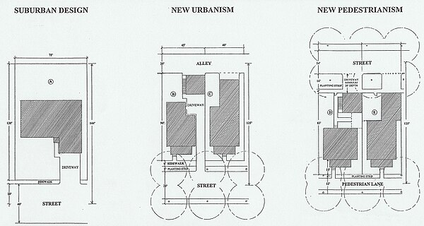
A pedestrian village is a compact, pedestrian-oriented neighborhood or town, with a mixed-use village center, that follows the tenets of New Pedestrianism. Shared-use lanes for pedestrians and those using bicycles, Segways, wheelchairs, and other small rolling conveyances that do not use internal combustion engines. Generally, these lanes are in front of the houses and businesses, and streets for motor vehicles are always at the rear. Some pedestrian villages might be nearly car-free with cars either hidden below the buildings or on the periphery of the village. Venice, Italy is essentially a pedestrian village with canals.

Transit mall urban street reserved for public transit vehicles, bicycles, and pedestrians

A transit mall is a street, or set of streets, in a city or town along which automobile traffic is prohibited or greatly restricted and only public transit vehicles, bicycles, and pedestrians are permitted.

Radburn design housing housing estate planning design

Radburn design housing is a concept for planned housing estates, based on a design that was originally used in Radburn, New Jersey, United States.

<i>Democracy and the Common Wealth</i> book by Michael E. Arth

Democracy and the Common Wealth: Breaking the Stranglehold of the Special Interests is a 2010 book by urban designer, policy analyst and artist Michael E. Arth. Arth attempts to expose what he calls the "dirty secrets" of America's electoral system, and provides a list of solutions that he believes will result in a "truly representative democracy." This democracy would be led by effective, trustworthy leaders, who would be elected by a majority, and who would not have to spend their time raising campaign funds, or catering to paid lobbyists.

References

  1. 1 2 Digby Hall, "New Urbanism vs. New Pedestrianism," Green Futures, October 9, 2013
  2. Azzurro, Amerika, "New Pedestrianism"
  3. Sisco, Beltlandia, "Will the BelLine Birth New Pedestrianism?"
  4. 1 2 Arth, Michael E. (2010). Democracy and the Common Wealth: Breaking the Stranglehold of the Special Interests Golden Apples Media, ISBN   978-0-912467-12-2. pp. 120-139, 363-386
  5. Website about Democracy and the Common Wealth
  6. 1 2 3 4 5 6 7 Michael E. Arth, The Labors of Hercules: Modern Solutions to 12 Herculean Problems. 2007 Online edition. Labor IX: Urbanism
  7. New Pedestrianism information
  8. Michael E. Arth, "Pedestrian Villages are the Antidote to Sprawl" The DeLand-Deltona Beacon, May 29, 2003. Page 1D.
  9. Morris Sullivan, "Town designer solves problem areas." Daytona Beach News-Journal, January 15, 2006, p. 10H.
  10. National Highway & Traffic Safety Administration (NHTSA)
  11. Surface Transportation Policy Project
  12. National Center for Health Statistics
  13. The International Center for Technology Assessment, "The Real Price of Gasoline, Executive Summary Archived 2007-06-09 at the Wayback Machine " 1998.
  14. John B. Lansing, Robert W. Marans and Robert B. Zehner, Planned Residential Environments (Ann Arbor: University of Michigan, 1970), p. 213
  15. Village Homes
  16. Michael E. Arth "New Orleans is Opportunity for Better Urban Planning," The Dayton News-Journal, Section B, October 30, 2005.
  17. Michael E. Arth "New Orleans Offers Chance for Better Planning Archived 2007-09-28 at the Wayback Machine "
  18. "Democracy and the Common Wealth". MichaelEarth.com. A website about the book.
  19. "New Urban Cowboy". GoldenApplesMedia.com.
  20. "New Urban Cowboy". NewUrbanCowboy.com.
  21. Villages for the Homeless website

Further reading