
Mtwara Region is one of Tanzania's 31 administrative regions. The regional capital is the municipality of Mtwara. Mtwara Region is home to one of the most infuluencial people in Tanzania, the Makonde. Mtwara is home to Tanzania's 4th president Benjamin Mkapa and is home to a number of influential artists. The boundary with Mozambique to the south is formed by the Ruvuma River. To the west, Mtwara is bordered by Ruvuma Region, to the north by Lindi Region, and to the east is the Indian Ocean.

Ludewa District is one of six districts in the Njombe Region in Tanzania, East Africa. Prior to 2012, the district was one of the seven districts of Iringa Region. The town of Ludewa is the administrative seat of the district. A hospital is located in the city. The district is bordered to the north by the Njombe Rural District and Makete District, to the southeast by the Ruvuma Region and to the southwest by the country of Malawi across Lake Nyasa.

Sengerema District is one of seven districts in the Mwanza Region of Tanzania, East Africa. Its administrative headquarter is located in Sengerema city. It is bordered to the north and east by Lake Victoria, to the south by Geita Region and to the southeast by the Misungwi District. Sengerema district is known for having numerous lake islands in its territory the largest are Maisome Island and Kome Island.
Ruangwa is one of six districts of the Lindi Region of Tanzania. It is bordered to the north by the Kilwa District, to the south by the Mtwara Region and to the west by the Nachingwea District.

Masasi is one of the six districts of the Mtwara Region of Tanzania. It is bordered to the north by the Lindi Region, to the east by the Newala District, to the south by the Ruvuma River and Mozambique and to the west by Nanyumbu District.

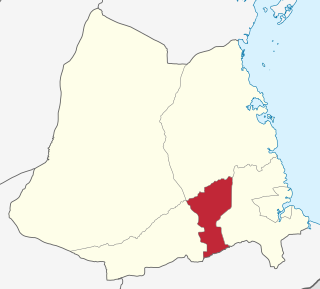
Mtwara District is one of the five districts of the Mtwara Region of Tanzania. It is bordered to the south by Mozambique, to the west by the Tandahimba District, to the north by the Lindi Region and to the east by Mtwara-Mikindani District and the Indian Ocean.

Mchafukoge is an administrative ward and district capital of the Ilala district in the Dar es Salaam Region of Tanzania. Kisutu and Kivukoni wards form the ward's northern boundary. The Dar es Salaam Harbor forms its eastern border. The Temeke District wards of Kurasini and Keko border it on the south. Kariakoo and Jangwani wards border the ward to the west. The ward is home to the Uhuru Monument, the Central Railway Station, and the headquarters for Tanzania Revenue Authority at Mapato House. In 2016 the Tanzania National Bureau of Statistics reported there were 13,384 people in the ward, from 10,688 in 2012.
Idamba is a town and ward in Njombe district in the Iringa Region of the Tanzanian Southern Highlands. In 2016 the Tanzania National Bureau of Statistics report there were 3,250 people in the ward, from 3,148 in 2012.
Igongolo is a town and ward in Njombe district in the Iringa Region of the Tanzanian Southern Highlands. In 2016 the Tanzania National Bureau of Statistics report there were 8,720 people in the ward, from 8,447 in 2012.
Ikondo is a town and ward in Njombe district in the Njombe Region of the Tanzanian Southern Highlands. In 2016 the Tanzania National Bureau of Statistics report there were 7,163 people in the ward, from 6,312 in 2012.
Ikuna (Ikuka) is a town and ward in Njombe Rural District in the Njombe Region of the Tanzanian Southern Highlands. In 2016 the Tanzania National Bureau of Statistics report there were 9,474 people in the ward, from 9,178 in 2012.
Lupembe is a town and ward in Njombe Rural District in the Njombe Region of the Tanzanian Southern Highlands.
Mahongole is a town and ward in Njombe district in the Iringa Region of the Tanzanian Southern Highlands. In 2016 the Tanzania National Bureau of Statistics report there were 9,520 people in the ward, from 9,222 in 2012.
Kindi is a town and ward in the Moshi Rural district of the Kilimanjaro Region of Tanzania. In 2016 the Tanzania National Bureau of Statistics report there were 22,943 people in the ward, from 21,391 in 2012.
Okaoni is a town and ward in the Moshi Rural district of the Kilimanjaro Region of Tanzania. In 2016 the Tanzania National Bureau of Statistics report there were 11,204 people in the ward, from 10,446 in 2012.
Uru Mashariki is a town and ward in the Moshi Rural district of the Kilimanjaro Region of Tanzania. In 2016 the Tanzania National Bureau of Statistics report there were 15,853 people in the ward, from 14,781 in 2012.
Kahama is an administrative ward in Kahama Urban District, Shinyanga Region, Tanzania with a postcode number 37304.In 2016 the Tanzania National Bureau of Statistics report there were 7,189 people in the ward, from 6,621 in 2012.

Mtwara Mikindani Municipal District Council is one of eight regional councils of the Mtwara Region in Tanzania. It is bordered to the north by the Lindi Region, to the east by the Indian Ocean and to the south and west by the Mtwara District. In 2016, the municipality has a total population of 113,732.

Nanyamba Town, is a district established in 2016 of the Mtwara Region in the southern coastal Tanzania. Nanyamba is in the eastern portion of the Mtwara Region, near the coast.

Newala Town, is a district level town council in the Mtwara Region in the southern coastal Tanzania. The town is in the south central portion of the Mtwara Region, on the northern bank of the Ruvuma River that is the border between Tanzania and Mozambique. The district was established on the 25th of September, 2015.

