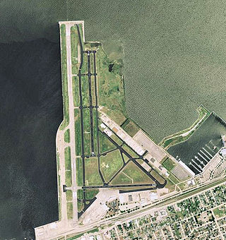
Lakefront Airport is a public airport five miles northeast of downtown New Orleans, in Orleans Parish, Louisiana, United States. The National Plan of Integrated Airport Systems for 2011–2015 categorized it as a general aviation reliever airport.

Alexandria International Airport is a public use airport located four nautical miles west of the central business district of Alexandria, in Rapides Parish, Louisiana, United States. The airport is operated by the England Authority, also known as the England Economic and Industrial Development District, an independent political subdivision of the State of Louisiana. Although international commercial flight operations are not conducted, charter flights for the U.S. military to international destinations are routinely conducted from the airfield with this activity including the transportation of U.S. troops to overseas locations.
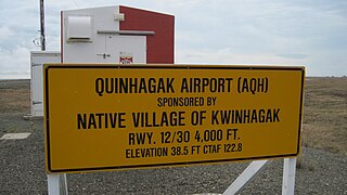
Quinhagak Airport, is a public-use airport located two nautical miles (3.7 km) east of the central business district of Quinhagak, a city in the Bethel Census Area of the U.S. state of Alaska. It is also known as Kwinhagak Airport.
Ruston Regional Airport is a public use airport in Lincoln Parish, Louisiana, United States. It is owned by the City of Ruston and is located three nautical miles (6 km) east of its central business district.
Allen Parish Airport is a public use airport in Allen Parish, Louisiana, United States. It is owned by the Allen Parish Police Jury and located four nautical miles south of the central business district of Oakdale, Louisiana. This airport is included in the National Plan of Integrated Airport Systems for 2011–2015, which categorized it as a general aviation facility.
Minden Airport is a public use airport in Webster Parish, Louisiana, United States. The airport is owned by the City of Minden and located two nautical miles (4 km) northwest of its central business district. It was formerly known as Minden-Webster Airport.
Scammon Bay Airport is a state-owned public-use airport located in Scammon Bay, a city in the Kusilvak Census Area of the U.S. state of Alaska.
Hammond Northshore Regional Airport is a city-owned, public-use, joint civil-military, general aviation airport located three nautical miles (6 km) northeast of the central business district of Hammond, a city in Tangipahoa Parish, Louisiana, United States. The airport was previously an uncontrolled facility utilizing VHF-band UNICOM as a Common Traffic Advisory Frequency (CTAF). As a result of the relocation of Army National Guard flight operations from Lakefront Airport to Hammond, a new control tower was constructed at the airport. This tower, staffed by military air traffic controllers from the Air Operations Department of the Louisiana Army National Guard's Army Aviation Support Facility #1 at the airport, became operational on 15 December 2014.
Abbeville Chris Crusta Memorial Airport is a city-owned, public-use airport located three nautical miles east of the central business district of Abbeville, a city in Vermilion Parish, Louisiana, United States.
Shreveport Downtown Airport is a public use airport located in the Bossier Parish portion of Shreveport, Louisiana, United States. It is closer to downtown Shreveport than the larger Shreveport Regional Airport. It is owned by the Shreveport Airport Authority.
Vivian Airport is a town-owned public-use airport located two nautical miles southwest of the central business district of Vivian, a town in Caddo Parish, Louisiana, United States. The airport is 25 miles north of Shreveport, Louisiana and it is also known as Vivian Municipal Airport.
Perryville Airport is a state-owned, public-use airport located one nautical mile southwest of the central business district of Perryville, in the Lake and Peninsula Borough of the U.S. state of Alaska. Scheduled airline service to King Salmon Airport is provided by Peninsula Airways (PenAir).
False River Regional Airport is a public use airport located two nautical miles northwest of the central business district of New Roads, a city in Pointe Coupee Parish, Louisiana, United States. The airport is owned by New Roads and Pointe Coupee Parish. According to the FAA's National Plan of Integrated Airport Systems for 2009–2013, it was classified as a general aviation airport.
Nondalton Airport is a state-owned public-use airport located one nautical mile (1.85 km) northwest of the central business district of Nondalton, in the Lake and Peninsula Borough of the U.S. state of Alaska.
Southland Field is a public-use airport located five nautical miles (9 km) south of the central business district of Sulphur, a city in Calcasieu Parish, Louisiana, United States. It is owned by the West Calcasieu Airport Managing Board and is also known as West Calcasieu Airport.
Arcadia–Bienville Parish Airport is a public-use airport located two nautical miles southwest of the central business district of Arcadia, in Bienville Parish, Louisiana, United States. It is owned by the City of Arcadia.
Caldwell Parish Airport is a public use airport in Caldwell Parish, Louisiana, United States. It is owned by the Caldwell Parish Police Jury and located two nautical miles (4 km) northeast of the central business district of Columbia, Louisiana. It was formerly known as Columbia Airport.
South Lafourche Leonard Miller Jr. Airport is a public use airport in Lafourche Parish, Louisiana, United States. It is owned by the Greater Lafourche Port Commission and located one nautical mile (2 km) east of the central business district of Galliano, Louisiana. This airport is included in the National Plan of Integrated Airport Systems for 2011–2015, which categorized it as a general aviation facility.
Leesville Airport is a city-owned, public-use general aviation airport located 4 nautical miles (7.4 km) west of Leesville, a city in Vernon Parish, Louisiana, United States.

