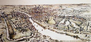
A motte-and-bailey castle is a European fortification with a wooden or stone keep situated on a raised area of ground called a motte, accompanied by a walled courtyard, or bailey, surrounded by a protective ditch and palisade. Relatively easy to build with unskilled labour, but still militarily formidable, these castles were built across northern Europe from the 10th century onwards, spreading from Normandy and Anjou in France, into the Holy Roman Empire in the 11th century. The Normans introduced the design into England and Wales. Motte-and-bailey castles were adopted in Scotland, Ireland, the Low Countries and Denmark in the 12th and 13th centuries. Windsor Castle, in England, is an example of a motte-and-bailey castle. By the end of the 13th century, the design was largely superseded by alternative forms of fortification, but the earthworks remain a prominent feature in many countries.

Sandal Castle is a ruined medieval castle in Sandal Magna, a suburb of the city of Wakefield in West Yorkshire, England, overlooking the River Calder. It was the site of royal intrigue and the setting for a scene in one of William Shakespeare's plays.

Restormel Castle lies by the River Fowey near Lostwithiel in Cornwall, England, UK. It is one of the four chief Norman castles of Cornwall, the others being Launceston, Tintagel and Trematon. The castle is notable for its perfectly circular design. Although once a luxurious residence of the Earl of Cornwall, the castle was all but ruined by the 16th century. It was briefly reoccupied and fought over during the English Civil War but was subsequently abandoned. It is now under the supervision of the English Heritage and open to the public.

Cooling Castle is a 14th-century quadrangular castle in the village of Cooling, Kent on the Hoo Peninsula about 6 miles (9.7 km) north of Rochester. It was built in the 1380s by the Cobham family, the local lords of the manor, to guard the area against French raids into the Thames Estuary. The castle has an unusual layout, comprising two walled wards of unequal size next to each other, surrounded by moats and ditches. It was the earliest English castle designed for the use of gunpowder weapons by its defenders.

Skipsea Castle was a Norman motte and bailey castle near the village of Skipsea, East Riding of Yorkshire, England. Built around 1086 by Drogo de la Beuvrière, apparently on the remains of an Iron Age mound, it was designed to secure the newly conquered region, defend against any potential Danish invasion and control the trade route across the region leading to the North Sea. The motte and the bailey were separated by Skipsea Mere, an artificial lake that was linked to the sea during the medieval period via a navigable channel. The village of Skipsea grew up beside the castle church, and the fortified town of Skipsea Brough was built alongside the castle around 1160 to capitalise on the potential trade.

Doddington is a village and civil parish in the district of Swale in Kent, England. The Syndale Valley shelters the central part in the Kent Downs Area of outstanding natural beauty. Today the village is notable for Doddington Place Gardens, for its remarkably well kept buildings and its house prices show higher prices than the home counties average.
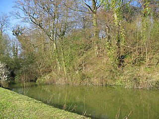
Anstey Castle was in the village of Anstey, Hertfordshire. It was a 12th-century stone motte and bailey fortress that, according to tradition, was founded by Eustace II, Count of Boulogne. It was either him, or one of his immediate progeny who established the first earthwork castle here. The castle had most probably been in existence for some time when the estate was acquired by Geoffrey de Mandeville, for he sought to strengthen his estate in the surrounding valley. It passed into the hands of the de Anstey family in the middle of the 12th century and was strengthened during the First Barons' War of 1215–1216 by Nicholas de Anstey, an opponent of King John, fighting for the barons. After the war ended de Anstey was commanded in 1218 to destroy the castle, with only those parts to remain that had been built before the war. The material from this demolition was supposed to be used in order to repair the nearby church, therefore the crest and shield from the castle feature in the church graffiti.

Ascot d'Oilly Castle is situated north of the village of Ascott-under-Wychwood in the north west region of Oxfordshire. It is a scheduled ancient monument. A fragment of the castle remains and is a Grade II listed building. It was named after Roger d'Oilly who was granted it by William the Conqueror and whose brother built Oxford Castle. It is thought that the castle was built around 1129 and it was demolished soon after 1175. There are fragmentary remains of a stone tower. The remains consist of raised ground surrounded by broad ditching.
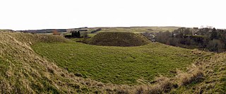
Elsdon Castle is a castle in the village of Elsdon about 10 miles (16 km) to the southwest of Rothbury, in Northumberland, England, and also known as Mote Hills. The site is a Scheduled Ancient Monument.

The remains of Aberedw Castle, also known as 'Castle in Elfael Uwch Mynydd', are located at the small village of Aberedw in the county of Powys, Mid-Wales. It was built in the late twelfth century and probably replaced the motte and bailey castle a few hundred metres away.
Watch Hill Castle is an early medieval motte-and-bailey on the border of Bowdon and Dunham Massey, England. It is a scheduled monument. As the only Scheduled Ancient Monument in Trafford, it is arguably the most important archaeological site in the borough. The castle is located north of the River Bollin and south of a deep ravine.
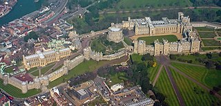
A shell keep is a style of medieval fortification, best described as a stone structure circling the top of a motte.

Pilsbury Castle was a Norman castle in Derbyshire near the present-day village of Pilsbury, overlooking the River Dove.
Kingsley Castle, also known as Castle Cob, a medieval motte in Kingsley, Cheshire, England. It is listed as a Scheduled Ancient Monument. The motte is a cone shaped mound, 2.8 metres (9.2 ft) high; it has a diameter of 23 metres (75 ft) at the base and tapers to 6 metres (20 ft) at the top. It is artificial and made from black soil.

Ratley is a village in the civil parish of Ratley and Upton, Stratford-on-Avon District, Warwickshire, England. The population of the civil parish in 2011 was 327. It is on the northwest side of the Edge Hill escarpment about 200 metres (660 ft) above sea level. The village is close to the county border with north Oxfordshire, some 7 miles northwest of Banbury, the closest town.
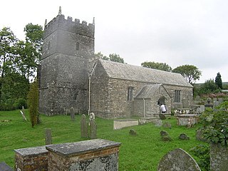
Parracombe is a rural settlement 4 miles (6 km) south-west of Lynton, in Devon, England. It is situated in the Heddon Valley, on Exmoor. The population at the 2011 census was 293.

Whorlton Castle is a ruined medieval castle situated near the abandoned village of Whorlton in North Yorkshire, England. It was established in the early 12th century as a Norman motte-and-bailey associated with the nearby settlement. The castle is an unusual example of a motte-and-bailey that remained in use throughout the Middle Ages and into the early modern period.

Penstowe Castle, also called Kilkhampton Castle, was a medieval fortification built near Kilkhampton, Cornwall, England, possibly during the years of the civil war in the 12th century known as the Anarchy.

Edburton Castle Ring is an archaeological site in West Sussex, England, on the peak of Edburton Hill on the South Downs, near the villages of Edburton and Fulking. It is a Scheduled Monument.


