
Rockford is a town in Coosa County, Alabama, United States. At the 2010 census the population was 477. The town is the county seat of Coosa County and is part of the Talladega-Sylacauga Micropolitan Statistical Area.
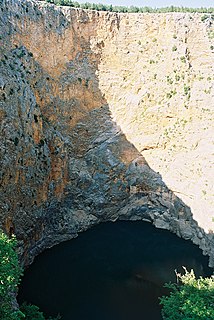
A sinkhole, also known as a cenote, sink, sink-hole, swallet, swallow hole, or doline, is a depression or hole in the ground caused by some form of collapse of the surface layer. Most are caused by karst processes – the chemical dissolution of carbonate rocks or suffosion processes. Sinkholes vary in size from 1 to 600 m both in diameter and depth, and vary in form from soil-lined bowls to bedrock-edged chasms. Sinkholes may form gradually or suddenly, and are found worldwide.

Cossatot River State Park-Natural Area is a 5,299.65-acre (2,144.69 ha) Arkansas state park in Howard County and Polk County, Arkansas in the United States. The park follows a rough, undeveloped 12.5 miles (20.1 km) of the Cossatot River. The river itself is included in Arkansas's Natural and Scenic Rivers System and the National Park Service's list of National Wild and Scenic Rivers, making it a whitewater rafting destination. The rough nature of the river, including Class III, IV, and dangerous Class V rapids, make the park-natural area a popular destination for skilled canoeists, kayakers, and playboaters. The park became a part of the system in 1988 after the Arkansas Department of Parks and Tourism and Arkansas Natural Heritage Commission agreed to cooperative management after acquiring the property from the Weyerhaeuser Corporation.

Paparoa National Park is on the west coast of the South Island of New Zealand.

The Buffalo River is the longest unimpounded river in Middle Tennessee in the United States, flowing 125 miles (201 km) through the southern and western portions of that region. It is the largest tributary of the Duck River and is used for canoeing, especially in its middle section. The river is named for the Buffalo fish which was abundant when the first European settlers arrived.

Lithia is an unincorporated community in Hillsborough County, Florida, United States. It is a suburb of Tampa. The ZIP codes are 33547, 33596, and the area code is 813. It is part of the census-designated place (CDP) of Fish Hawk. Lithia is home to the 2,963-acre (1,199 ha) Alafia River Corridor and 5,515-acre (2,232 ha) Chito Branch Reserve.

Little River Canyon National Preserve is a United States National Preserve located on top of Lookout Mountain near Fort Payne, Alabama, and DeSoto State Park. Created by an Act of Congress in 1992, the 15,288-acre (6,187 ha) preserve protects what is sometimes said to be the nation's longest mountaintop river, the Little River. The canyon was historically called "May's Gulf", "gulf" being a common term throughout the Cumberland Plateau for this sort of feature. Prior to being assigned to the National Park Service, the canyon area formed the southmost unit of Alabama's DeSoto State Park.
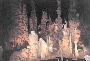
Cathedral Caverns State Park is a publicly owned recreation area and natural history preserve located in Kennamer Cove, Alabama, approximately 5 miles (8.0 km) northeast of Grant and 7 miles (11 km) southeast of Woodville in Marshall County. The park's main feature, first known as Bats Cave, was developed as a tourist attraction in the 1950s. Cathedral Caverns was declared a National Natural Landmark in 1972 and opened as a state park in 2000.

Buck's Pocket State Park is publicly owned recreation area located on Sand Mountain in the northeast corner of the U.S. state of Alabama, 2 miles (3.2 km) north of the community of Grove Oak. The state park occupies 2,000 acres (810 ha) surrounding a natural pocket (canyon) of the Appalachian Mountain chain along South Sauty Creek, an upstream tributary on the east side of Guntersville Lake. The park is known for the sweeping views of its rugged, seemingly untouched landscape provided from the heights of Point Rock.

The Tallapoosa River runs 265 miles (426 km) from the southern end of the Appalachian Mountains in Georgia, United States, southward and westward into the Appalachian foothills in Alabama. It is formed by the confluence of McClendon Creek and Mud Creek in Paulding County, Georgia. Lake Martin at Alexander City, Alabama is a large and popular water recreation area formed by a dam on the river. The Tallapoosa joins the Coosa River about 10 miles (16 km) northeast of Montgomery near Wetumpka to form the Alabama River.

Harrison Spring is the largest spring in the U.S. state of Indiana. It is located in west-central Harrison County, near the Blue River and just north of White Cloud.

Logan Martin Lake is a reservoir located in east central Alabama on the Coosa River approximately 30 miles (48 km) east of Birmingham, Alabama. This 17,000-acre (69 km2) reservoir was built in 1965 by Alabama Power Company. The lake, nicknamed Lake of a Thousand Coves by locals, has 275 miles (443 km) of shoreline along its 48.5-mile (78.1 km) length sandwiched between Logan Martin Dam on the south and Neely Henry Dam on the north. The depth of the lake is 35 to 110 feet (34 m) with only five feet average water level variance. Logan Martin Lake offers boating, skiing and swimming.

Twin Caves is a pair of cave entrances connected by a short river at the bottom of a sinkhole within the boundaries of Spring Mill State Park in Lawrence County, Indiana. The river is an exposed section of a mostly-underground stream that originates as Mosquito Creek several miles southeast of the park, which sinks into the Upper Twin Cave system. The stream then comes out briefly at Twin Caves, and flows into the Lower Twin Cave, re-emerging briefly at Bronson Cave shortly to the northwest, then flowing into the Shawnee Cave System. The stream finally emerges at the Donaldson Cave entrance as a short tributary of Mill Creek, still within the park.

Frank Jackson State Park is a publicly owned recreation area that wraps around Lake Frank Jackson and forms the northwesternmost portion of the city of Opp, Alabama. The 2,050-acre (830 ha) state park offers facilities for fishing, boating, hiking, and camping.

Lake Lurleen State Park is a publicly owned recreation area located on U.S. Highway 82 approximately 9 miles (14 km) northwest of Northport in Tuscaloosa County, Alabama. The state park's 1,625 acres (658 ha) include 250-acre (100 ha) Lake Lurleen and a 23-mile (37 km) trail system. It is operated by the Alabama Department of Conservation and Natural Resources.

Cedars of Lebanon State Park is a state park in Wilson County, Tennessee, in the southeastern United States. It consists of 900 acres (364 ha) situated amidst the 9,420-acre (3,810 ha) Cedars of Lebanon State Forest. The park and forest are approximately 10 miles (16 km) south of Lebanon, Tennessee.

The William "Bill" Dannelly Reservoir is a reservoir created by Millers Ferry Lock and Dam on the Alabama River in Dallas County and Wilcox County in Alabama. It covers 27 square miles (70 km2) and has approximately 500 miles (800 km) of shoreline. It was named for William "Bill" Dannelly, a former Wilcox County probate judge credited with leading the modernization of the Alabama and Coosa Rivers.

The Black Kettle National Grassland, in Roger Mills County, Oklahoma and Hemphill County, Texas, contains 31,286 acres (12,661 ha) of which 30,710 acres (12,430 ha) are in Oklahoma.
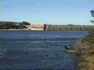
Lay Dam is a hydroelectric power dam on the Coosa River in Chilton County and Coosa County, near Clanton, Alabama.

