Related Research Articles
Burgh Castle is a village and civil parish in the English county of Norfolk. Burgh Castle is located 3.2 miles (5.1 km) south-west of Great Yarmouth and 16 miles (26 km) east of Norwich. The parish was part of Suffolk until 1974.

Cley next the Sea is a village and civil parish on the River Glaven in the English county of Norfolk.

Herringfleet is a place and former civil parish, now in the parish of Somerleyton, Ashby and Herringfleet, in the East Suffolk district, in the north of the English county of Suffolk. It is located 5.5 miles (8.9 km) north-west of Lowestoft. The parish was combined with Somerleyton and Ashby to create the parish of "Somerleyton, Ashby and Herringfleet" on 1 April 1987.

The Borough of Great Yarmouth is a local government district with borough status in Norfolk, England. It is named after its main town, Great Yarmouth, and also contains the town of Gorleston-on-Sea and a number of villages and rural areas, including part of The Broads. Other notable settlements include Caister-on-Sea, Hemsby, Hopton-on-Sea and Winterton-on-Sea.
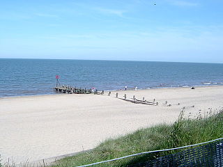
Hopton-on-Sea is a village, civil parish and seaside resort on the coast of East Anglia, in the county of Norfolk, England. It is located 4 miles (6 km) south of Great Yarmouth and 5 miles (8 km) north-west of Lowestoft.

Bradwell is a village and civil parish in the English county of Norfolk. The village is immediately to the west of, and largely indistinguishable from, the built-up urban area of the town of Great Yarmouth.

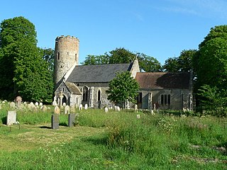
Corton is a village and civil parish in the north of the English county of Suffolk. It is 3 miles (4.8 km) north of the centre of Lowestoft in the East Suffolk district. The village is on the North Sea coast with the county border with Norfolk to the north.

Blundeston is a village and civil parish in the north of the English county of Suffolk. It is 3.5 miles (5.6 km) north-west of Lowestoft, 6 miles (9.7 km) south of Great Yarmouth and around 1.75 miles (2.82 km) inland from the North Sea coast. It is part of the area known as Lothingland in the East Suffolk district. Blundeston Prison was located on the southern edge of the village but closed in early 2014.

Lothingland was a rural district in East Suffolk, England, named after the ancient half-hundred of Lothingland which was merged with Mutford half-hundred in 1763 to form Mutford and Lothingland.

Fritton is a village and former civil parish in county of Norfolk, England. The village is located 6 miles (9.7 km) south-west of Great Yarmouth and 16 miles (26 km) south-east of Norwich, along the A143 between Gorleston-on-Sea and Haverhill. In 1961 the parish had a population of 192.
Hemsby is a village, seaside resort and civil parish in the county of Norfolk, England. It is situated some 8 mi (13 km) north of the town of Great Yarmouth. In the 2001 census Hemsby had a population of 2,973 in 1,221 households; by the 2011 census it had increased to 3,275. Hemsby borders the villages of Winterton-on-Sea and Scratby. For the purpose of local government, the parish is in the district of Great Yarmouth.

Covehithe is a village and civil parish in the East Suffolk district of the English county of Suffolk. It lies on the North Sea coast around four miles north of Southwold and seven miles south of Lowestoft. Neighbouring settlements include Benacre, South Cove and Frostenden.
Frostenden is a village and civil parish in the East Suffolk district of the English county of Suffolk. It is around 8 miles (13 km) south-west of Lowestoft and 3.5 miles (5.6 km) north-west of Southwold and lies on the A12 road between Wrentham and Wangford. Neighbouring parishes include Wrentham, Sotterley, Uggeshall, Wangford with Henham, Reydon and South Cove.

Sisland, historically Sislanda, is a very small village, manor and parish in the county of Norfolk, England, about a mile west of Loddon. In the 2001 census, the population was 44 in 16 households. The parish covers an area of 1.90 km2 (0.73 sq mi), and is approximately 9.3 miles (15.0 km) southeast of Norwich and 12.7 miles (20.4 km) west of Great Yarmouth. For the purposes of local government, it falls within the district of South Norfolk, however Sisland does have its own Parish Council. The village contains only one heritage-listed building, that being St Mary's Church, which is Grade II*.

Thrandeston is a small village on the Norfolk/Suffolk border in England.

Lound is a village and civil parish in the north of the English county of Suffolk. It is 4.5 miles (7.2 km) north of Lowestoft, 5 miles (8.0 km) south of Great Yarmouth in the East Suffolk district. It is 2 miles (3.2 km) from the North Sea coast at Hopton-on-Sea and is on the border with the county of Norfolk.
The Yarmouth–Lowestoft line was a railway line which linked the coastal towns of Yarmouth, Gorleston-on-Sea and Lowestoft in the counties of Norfolk and Suffolk, England. It opened on 13 July 1903 as the first direct railway link between the two towns; it was constructed by the Great Eastern Railway and the Midland and Great Northern Railway in the hope of encouraging the development of holiday resorts along the coast. In the event, although the line was built to high standards and considerable cost, intermediate traffic did not develop and competition from buses and trams eroded the little that had been generated.
Mutford and Lothingland was a hundred of Suffolk, with an area of 33,368 acres (135.04 km2). Lowestoft Ness, the most easterly point of Great Britain fell within its bounds.
The East Anglian League was a football league in the East Anglia region of England.

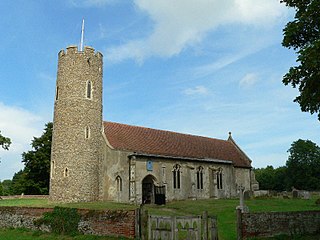
St Margaret's Church is the parish church of Hopton-on-Sea in the English county of Norfolk. It is dedicated to St Margaret of Antioch. St Margaret is also the dedication of the former church, which was destroyed by fire in 1865. The ruins of the former church remain standing, and are still consecrated. Both the old and new churches are Grade II* listed. Until 1974, Hopton-on-Sea was called Hopton ; the formal name for the benefice remains Hopton. The church is in the Diocese of Norwich, and is within the deanery of Lothingland and archdeaconry of Norfolk.
References
Citations
- 1 2 Clark, p. 11.
- ↑ Newton, Open Domesday. Retrieved 17 January 2020.
- ↑ Clark, p.13.
- ↑ Clark, p.12.
- 1 2 Clark, p.14.
- ↑ Ecclestone, AW (1971) Henry Manship's Great Yarmouth, pp.74, 77.
- ↑ "Norfolk Heritage Explorer: Newton Deserted Medieval Village" . Retrieved 15 January 2021.
- 1 2 3 4 Monument record COR 073 - Church of St Mary; Newton; The Gate. Formerly recorded as COR Misc, Suffolk Heritage Explorer, Suffolk County Council. Retrieved 17 January 2020.
- 1 2 "A Short History of Corton" . Retrieved 15 January 2021.
- ↑ Pratt, David, "RAF Hopton", in Barker, Darren, op. cit., pp.52–55.
- ↑ Clapham, Lucy (1 April 2014). "The day six Suffolk villages moved into Norfolk – and it definitely wasn't an April Fools' joke". Eastern Daily Press . Retrieved 15 January 2021.
- 1 2 Corton, Parish Histories, Suffolk Heritage Explorer, Suffolk County Council. Retrieved 17 January 2021.
- ↑ Chapman, Christopher (1985) 'Bleak and Lonely': Old St Margaret's Church, Hopton-on-Sea, Norfolk, p.1. Hopton-on-Sea: St Margaret's, Hopton.
- ↑ Clark, p.16.
Bibliography
- Clark, Malcolm (2016) "Hopton and Newton 1066 to 1275 and the Demise of Newton", in Barker, Darren, Hopton-on-Sea: Exploring the Past, pp.10–16. Great Yarmouth: Great Yarmouth Preservation Trust.
52°32′10″N1°44′31″E / 52.536°N 1.742°E (approx.)