Related Research Articles

The Broads is a network of mostly navigable rivers and lakes in the English counties of Norfolk and Suffolk. Although the terms "Norfolk Broads" and "Suffolk Broads" are correctly used to identify specific areas within the two counties respectively, the whole area is frequently referred to as the Norfolk Broads.

The River Waveney is a river which forms the boundary between Suffolk and Norfolk, England, for much of its length within The Broads. The earliest attestation of the name is from 1275, Wahenhe, from *wagen + ea, meaning the river by a quagmire.

Lowestoft is a coastal town and civil parish in the East Suffolk district of Suffolk, England. As the most easterly UK settlement, it is 38 miles (61 km) north-east of Ipswich and 22 miles (35 km) south-east of Norwich, and the main town in its district. Its development grew with the fishing industry and as a seaside resort with wide sandy beaches. As fishing declined, oil and gas exploitation in the North Sea in the 1960s took over. In 2021 the built-up area had a population of 71,327 and the parish had a population of 47,879.

The Haddiscoe Cut or New Cut is a canal in the English county of Norfolk and in The Broads National Park.). The cut was conceived as a way to provide a more direct route from Lowestoft to Norwich, and was built as part of a larger scheme which included the linking of the River Waveney to Oulton Broad and Lake Lothing. It was opened in 1833, but the new route was not a financial success, and it was sold to a railway developer in 1842. It remained in railway ownership until Nationalisation in 1948, and was damaged by floods in 1953. An attempt to close it in 1954 was resisted by local interests, resulting in it being repaired. It is now managed by the Environment Agency.

The River Yare is a river in the English county of Norfolk. In its lower reaches it is one of the principal navigable waterways of The Broads and connects with the rest of the network.

East Suffolk, along with West Suffolk, was created in 1888 as an administrative county of England. The administrative county was based on the eastern quarter sessions division of Suffolk. East Suffolk County Council's headquarters were at East Suffolk County Hall in Ipswich.

The Borough of Great Yarmouth is a local government district with borough status in Norfolk, England. It is named after its main town, Great Yarmouth, and also contains the town of Gorleston-on-Sea and a number of villages and rural areas, including part of The Broads. Other notable settlements include Caister-on-Sea, Hemsby, Hopton-on-Sea and Winterton-on-Sea.
Oulton Broad refers to both the lake and the suburb of Lowestoft, Suffolk, England.
Waveney was a constituency of in the House of Commons of the UK Parliament that existed from 1983 to 2024. It returned one Member of Parliament (MP) to the House of Commons of the Parliament of the United Kingdom.
Barnby is a village and civil parish in the East Suffolk district of Suffolk, England. The village is 5 miles (8.0 km) west of Lowestoft and 3 miles (4.8 km) east of Beccles in the north of the county. It is effectively merged with the village of North Cove which constitutes a separate parish.

Lothingland was a rural district in East Suffolk, England, named after the ancient half-hundred of Lothingland which was merged with Mutford half-hundred in 1763 to form Mutford and Lothingland.

Lake Lothing is a saltwater lake located in Lowestoft in the English county of Suffolk. The lake, which is believed to be the remnant of medieval peat cutting, flows into the North Sea and forms part of the Port of Lowestoft. The area was the major industrial centre of Lowestoft with ship building and other engineering industries, much of which has now closed.

Lowestoft is a parliamentary constituency centred on the town of Lowestoft in Suffolk. It returns one Member of Parliament (MP) to the House of Commons of the Parliament of the United Kingdom, elected by the first past the post voting system.

The A146 is an A road that connects Norwich in Norfolk and Lowestoft in Suffolk, two of East Anglia's largest population centres. It is around 27 miles (43 km) in length and has primary classification along its entire route. It is mainly single carriageway throughout its route, with the exception of a section of dual carriageway on the southern edge of Norwich.

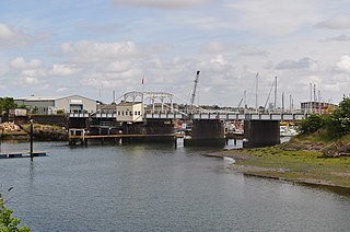
The Port of Lowestoft is a harbour and commercial port in Lowestoft in the English county of Suffolk owned by Associated British Ports. It is the most easterly harbour in the United Kingdom and has direct sea access to the North Sea. The harbour is made up of two sections divided by a bascule bridge. The inner harbour is formed by Lake Lothing whilst the outer harbour is constructed from breakwaters. Lowestoft handles around 30,000 tonnes of cargo per year.
Mutford and Lothingland was a hundred of Suffolk, with an area of 33,368 acres (135.04 km2). Lowestoft Ness, the most easterly point of Great Britain fell within its bounds.

Flixton is a civil parish in the north of the English county of Suffolk. It is 2 miles (3.2 km) north-east of Lowestoft in the East Suffolk district.

Mutford and Lothingland Rural District was a rural district within the administrative county of East Suffolk between 1894 and 1934. It was created out of the earlier Mutford and Lothingland rural sanitary district. It was named after the historic hundred of Mutford and Lothingland, whose boundaries it closely matched.

Oulton is a civil parish on the western edge of the town of Lowestoft in the north of the English county of Suffolk. It is in the East Suffolk district. The eastern part of the parish forms part of the suburbs of Lowestoft, whilst the western section extends into The Broads national park, reaching the River Waveney and Oulton Dyke.
References
- 1 2 William White (1844). History, gazetteer, and directory of Suffolk. p. 480.
- ↑ "Ward population 2011" . Retrieved 25 August 2015.
52°31′N1°42′E / 52.52°N 1.70°E
| | This Norfolk location article is a stub. You can help Wikipedia by expanding it. |
| | This Suffolk location article is a stub. You can help Wikipedia by expanding it. |