| Newtown Creek | |
|---|---|
 Newtown Creek Bridge | |
 Newtown Creek | |
| Location | |
| Country | United States |
| State | Pennsylvania |
| County | Bucks |
| Township | Newtown, Middletown |
| Borough | Newtown |
| Physical characteristics | |
| Source | |
| • coordinates | 40°15′56″N74°57′51″W / 40.26556°N 74.96417°W |
| • elevation | 320 feet (98 m) |
| Mouth | |
• coordinates | 40°12′39″N74°56′34″W / 40.21083°N 74.94278°W |
• elevation | 69 feet (21 m) |
| Length | 5.66 miles (9.11 km) |
| Basin size | 6.29 square miles (16.3 km2) |
| Basin features | |
| Progression | Newtown Creek → Neshaminy Creek → Delaware River → Delaware Bay |
| River system | Delaware River |
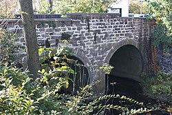
| Landmarks | All Saints Cemetery, Roberts Ridge Park, Newtown Cemetery, Newtown Creek Bridge, George School |
| Slope | 44.35 feet per mile (8.400 m/km) |
Newtown Creek is a tributary, rising near Stoop Road in Newtown Township, Bucks County, Pennsylvania, United States. [1] It is part of the Delaware River watershed [2] and is located entirely in Bucks County, Pennsylvania. [3] The Newtown Creek Bridge over Centre Avenue was added to the National Register of Historic Places in 1988.