
Magway Region is an administrative division in central Myanmar. It is the second largest of Myanmar's seven divisions, with an area of 44,820 km2. Pa Del Dam (ပဒဲဆည်) is one of the dams in Aunglan Township, Magway Division. The capital and second largest city of the Magway Division is Magway. The largest city is Pakokku. The major cities of Magway Division are Magway, Pakokku, Aunglan, Yenangyaung, Taungdwingyi, Chauk, Minbu, Thayet and Gangaw.

The Chindwin River, also known as the Ningthi River, is a river flowing entirely in Myanmar, and the largest tributary of the country's main river, the Ayeyarwady. Its official name is also spelled Chindwinn.
The Chin Hills are a range of mountains in Chin State, northwestern Burma (Myanmar), that extends northward into India's Manipur state.

Falam District is a district of the Chin State in Myanmar. It consists of 3 townships and 445 villages. The major towns include: Fort White, and Falam.

Falam Township is a township of Falam District in the Chin State of Burma (Myanmar). Its administrative seat is the town of Falam. The population, as of 2014, is 41,457. Out of this population, 9,092 live in Falam town and 32,365 live in rural areas.

Ton Zang Township is a township of Tedim District in the Chin State of Myanmar. The 3,471.24-square-kilometre Ton Zang township is bordered by Tedim (Tiddim) Township in the south, Kale Township of the Sagaing Division in the south-east, Tamu Township of the Sagaing Division in the north-east, the Indian state of Manipur in the north and the Indian state of Mizoram in the west.
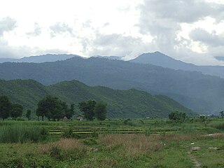
Fort White was a small military station built by the British Army under Field Marshal Sir George Stuart White, V.C., Commander-in-Chief of Upper Burma during their third expeditions in the annexation of the Chin Hills in 1889. Its location was on the eastern (leeward) side of the Letha Range midway between Kale and Tiddim towns in what is now the Tiddim Township of Chin State, Burma (Myanmar).

Mingin Township is a township of Kale District in Sagaing Division of Burma (Myanmar). The principal town and administrative seat is Mingin (Minking).
Mawlaik District is a district in central Sagaing Division of Burma (Myanmar). Its administrative center is the town of Mawlaik.

Myittha River is a river of western Burma, a tributary of the Chindwin River.
Kale District is the westernmost district in Sagaing Division of Myanmar (Burma).

Kalewa Township is a township of Kale District in Sagaing Division of Burma (Myanmar). The principal town and administrative seat is Kalewa. The Paluzawa coal mines are located in Kalewa township.

Hkamti Township or Khamti Township is a township in Hkamti District in the Sagaing Region of Burma (Myanmar). The principal town is Hkamti. As of 2014 the township had a population of 47,658 people and covered an area of 8,174 square kilometres (3,156 sq mi). The township is dominated by the Chindwin River and its tributaries as well as thickly forested areas. Nearly half the active working population are employed in agriculture, forestry or fishing. The township is a producer of rice and has gold and jade reserves.
Kale Township is a township in Kale District in the Sagaing Division of Burma (Myanmar). The principal town is Kalay.
Kyigon is a village in Kale Township, Kale District, in the Sagaing Region of western Burma (Myanmar). Kyigon is located on the left (north) bank of the Myittha River about 2.4 kilometres (1.5 mi) above where the Neyinzaya River enters the Myittha. It is about 8.8 kilometres (5.5 mi) northeast of the regional capital at Kalemyo.
Yazagyo is the northernmost village in Kale Township, Kale District, of western Burma (Myanmar).
Siyin is a village in Kale Township, Kale District, in the Sagaing Region of western Burma. It is located about 10 kilometres (6.2 mi) west of Kalemyo on the Kalemyo – Theizang road. It lies at the mouth of the Siyin Valley where it debouches into the Kale Valley.
The Tedim or Zomi language is spoken mostly in Myanmar and India. In Chin State (Khamtunggam), it is spoken in Tedim and Tonzang townships, while in Sagaing Division, it is spoken in Kalay and Mawlaik townships (Ethnologue). Dialects are Sokte and Kamhau. It is a subject-object verb language, and negation follows the verb.
Chin Baptist Convention is a Baptist Christian denomination Myanmar. The headquarters is in Falam, Chin State, Myanmar. It is a member of the Myanmar Baptist Convention.
The Zanniat tribe are people of western Myanmar (Burma) who are a sub-group of the Chin peoples. The Zanniat tribe has fifty-seven sub-groupings and clans. The group's existence was recorded in Burma's 1931 census after being absent in the Chin Hills gazette of 1896. In 1943, the Zanniat tribal groups of eastern Falam Township were recorded by Henry Stevenson. The Zanniat may also be known by similar sounding names such as Zahnyiet, Zanniet, Zanngiat and Zannaing.