Look up Niagara in Wiktionary, the free dictionary.
Niagara may refer to:
Niagara may refer to:

The Niagara River flows north from Lake Erie to Lake Ontario, forming part of the border between Ontario, Canada, to the west, and New York, United States, to the east. The origin of the river's name is debated. Iroquoian scholar Bruce Trigger suggests it is derived from a branch of the local Neutral Confederacy, referred to as the Niagagarega people on several late-17th-century French maps. George R. Stewart posits that it comes from an Iroquois town named Ongniaahra, meaning "point of land cut in two."

Niagara County is in the U.S. state of New York. As of the 2020 census, the population was 212,666. The county seat is Lockport. The county name is from the Iroquois word Onguiaahra; meaning the strait or thunder of waters. The county is part of the Western New York region of the state.
Huron may refer to:

The Niagara Escarpment is a long escarpment, or cuesta, in Canada and the United States that starts from the south shore of Lake Ontario westward, circumscribes the top of the Great Lakes Basin running from New York through Ontario, Michigan, and Wisconsin. The escarpment is the cliff over which the Niagara River plunges at Niagara Falls, for which it is named.
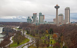
Niagara Falls is a city in the Canadian province of Ontario, adjacent to Niagara Falls. As of the 2021 census, the city had a population of 94,415. The city is located on the Niagara Peninsula along the western bank of the Niagara River, which forms part of the Canada–United States border, with the other side being the twin city of Niagara Falls, New York. Niagara Falls is within the Regional Municipality of Niagara and a part of the St. Catharines - Niagara Census Metropolitan Area (CMA). Tourism is a major part of the city's economy: its skyline is comprised of multiple high-rise hotels and observation towers that overlook the waterfalls and adjacent parkland. Souvenir shops, arcades, museums, amusement rides, indoor water parks, casinos, theatres and a convention centre are located nearby in the city's large tourist area. Other parts of the city include historic sites from the War of 1812, parks, golf courses, commercial spaces, and residential neighbourhoods.

Fort Erie is a town in the Niagara Region of Ontario, Canada. The town is located at the south eastern corner of the region, on the Niagara River, directly across the Canada–United States border from Buffalo, New York, and is the site of Old Fort Erie which played a prominent role in the War of 1812.
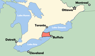
The Niagara Peninsula is an area of land lying between the southwestern shore of Lake Ontario and the northeastern shore of Lake Erie, in Ontario, Canada. Technically an isthmus rather than a peninsula, it stretches from the Niagara River in the east to Hamilton, Ontario, in the west. The peninsula is located in the Golden Horseshoe region of Southern Ontario, and has a population of roughly 1,000,000 residents. The region directly across the Niagara River and Lake Erie in New York State is known as the Niagara Frontier.

The Regional Municipality of Niagara, also colloquially known as the Niagara Region or Region of Niagara, is a regional municipality comprising twelve municipalities of Southern Ontario, Canada. The regional seat is in Thorold. It is the southern end of the Golden Horseshoe, the largest megalopolis in Canada.

Old Fort Erie, also known as Fort Erie, or the Fort Erie National Historic Site of Canada, was the first British fort to be constructed as part of a network developed after the Seven Years' War was concluded by the Treaty of Paris (1763), at which time France ceded its territories east of the Mississippi River to Great Britain. The installation is located on the southern edge of what is now the Town of Fort Erie, Ontario, directly across the Niagara River from Buffalo, New York, United States.

Queenston is a compact rural community and unincorporated place 5 kilometres (3.1 mi) north of Niagara Falls in the Town of Niagara-on-the-Lake, Ontario, Canada. It is bordered by Highway 405 to the south and the Niagara River to the east; its location at the eponymous Queenston Heights on the Niagara Escarpment led to the establishment of the Queenston Quarry in the area. Across the river and the Canada–US border is the village of Lewiston, New York. The Lewiston-Queenston Bridge links the two communities. This village is at the point where the Niagara River began eroding the Niagara Escarpment. During the ensuing 12,000 years the Falls cut an 11 kilometres (6.8 mi) long gorge in the Escarpment southward to its present-day position.
Chippawa is a community located within the city of Niagara Falls, Ontario.

Niagara Gorge is an 11 km (6.8 mi) long canyon carved by the Niagara River along the Canada–United States border, between the U.S. state of New York and the Canadian province of Ontario. It begins at the base of Niagara Falls and ends downriver at the edge of the geological formation known as the Niagara Escarpment near Queenston, Ontario, where the falls originated about 12,500 years ago. The position of the falls has receded upstream toward Lake Erie because of the falling waters' slow erosion of the riverbed's hard Lockport dolomite, combined with rapid erosion of the relatively soft layers beneath it. This erosion has created the gorge.
Timeline of the War of 1812 is a chronology of the War of 1812, including a list of battles.
The Niagara Parkway, formerly known as Niagara Boulevard and historically as the Niagara Road, is a scenic road in the province of Ontario that travels on the Canadian side of the Niagara River from the town of Fort Erie to Niagara-on-the-Lake. The portion north of Table Rock in the city of Niagara Falls is designated as an Ontario Scenic Highway. Niagara Boulevard originally referred only to the section from Fort Erie to Chippawa.
Navy Island Royal Naval Shipyard was a Royal Navy yard in Ontario.

Amherstburg Royal Naval Dockyard was a Provincial Marine and then a Royal Navy yard from 1796 to 1813 in Amherstburg, Ontario, situated on the Detroit River. The yard comprised blockhouses, storehouses, magazine, wood yard and wharf. The yard was established in 1796 to support the Upper Canada Provincial Marine after Great Britain ceded a pre-existing shipyard on the Detroit River to the United States. Amherstburg Royal Naval Dockyard constructed four warships for the Lake Erie detachment of the Provincial Marine before and during the War of 1812. In 1813 the dockyard was abandoned and destroyed when the British retreated and never reopened. In 1928, the site was designated a National Historic Site of Canada.

Provincial Marine was a coastal protection service in charge of the waters in the Great Lakes, the St. Lawrence River and parts of Lake Champlain under British control. While ships of the Provincial Marine were designated HMS, they were operated in more of a coast guard manner than as a full-fledged navy. Most ships of the Provincial Marine were built on the Great Lakes.

The Niagara Whirlpool is a natural whirlpool within the Niagara River located along the Canada–U.S. border between New York and Ontario. The whirlpool is in the Niagara Gorge, downstream from Niagara Falls. The whirlpool's greatest depth is 125 feet (38 m).

Transportation in Buffalo, New York is dominated by automobile use, but other modes of transportation exist in the city.