A distributary, or a distributary channel, is a stream that branches off and flows away from a main stream channel. Distributaries are a common feature of river deltas. The phenomenon is known as river bifurcation. The opposite of a distributary is a tributary, which flows towards and joins another stream. Distributaries are often found where a stream approaches a lake or an ocean. They can also occur inland, on alluvial fans, or where a tributary stream bifurcates as it nears its confluence with a larger stream. In some cases, a minor distributary can divert so much water from the main channel that it can later become the main route.

Poole Harbour is a large natural harbour in Dorset, southern England, with the town of Poole on its shores. The harbour is a drowned valley (ria) formed at the end of the last ice age and is the estuary of several rivers, the largest being the Frome. The harbour has a long history of human settlement stretching to pre-Roman times. The harbour is extremely shallow, with one main dredged channel through the harbour, from the mouth to Holes Bay.

The Bristol Channel is a major inlet in the island of Great Britain, separating South Wales from Devon and Somerset in South West England. It extends from the lower estuary of the River Severn to the North Atlantic Ocean. It takes its name from the English city of Bristol, and is over 30 miles (50 km) wide at its western limit.

The Strait of Georgia or the Georgia Strait is an arm of the Salish Sea between Vancouver Island and the extreme southwestern mainland coast of British Columbia, Canada and the extreme northwestern mainland coast of Washington, United States. It is approximately 240 kilometres (150 mi) long and varies in width from 20 to 58 kilometres. Along with the Strait of Juan de Fuca and Puget Sound, it is a constituent part of the Salish Sea.
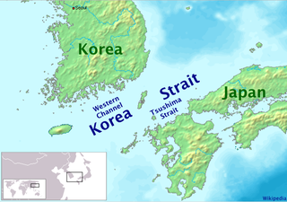
Tsushima Strait or Eastern Channel is a channel of the Korea Strait, which lies between Korea and Japan, connecting the Sea of Japan, the Yellow Sea, and the East China Sea.

The Maldives are formed by 20 natural atolls, along with a few islands and isolated reefs today which form a pattern stretching from 7 degrees 10′ North to 0 degrees 45′ South. The largest of these atolls is Boduthiladhunmathi, while the atoll containing the most islands is Huvadhu.

The North Jutlandic Island, Vendsyssel-Thy, or Jutland north of the Limfjord is the northernmost part of Denmark and of Jutland. It is more common to refer to the three traditional districts Vendsyssel, Hanherred and Thy, however. The area has been intermittently a tied island, and during modern times was not surrounded by water until a storm of February 1825, which severed the region from the remainder of Jutland and caused a water connection between the North Sea and the western end of the fjord Limfjorden. Hence it is traditionally regarded as a part of Jutland rather than an island.

The Elizabeth Islands are a chain of small islands extending southwest from the southern coast of Cape Cod, Massachusetts in the United States. They are located at the outer edge of Buzzards Bay, north of Martha's Vineyard, from which they are separated by Vineyard Sound, and constitute the town of Gosnold in Dukes County, Massachusetts.

The Gulf of Maine is a large gulf of the Atlantic Ocean on the east coast of North America. It is bounded by Cape Cod at the eastern tip of Massachusetts in the southwest and by Cape Sable Island at the southern tip of Nova Scotia in the northeast. The gulf includes the entire coastlines of the U.S. states of New Hampshire and Maine, as well as Massachusetts north of Cape Cod, and the southern and western coastlines of the Canadian provinces of New Brunswick and Nova Scotia, respectively.
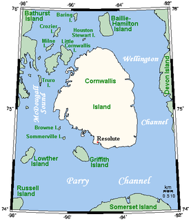
Cornwallis Island is one of the Queen Elizabeth Islands, part of the Arctic Archipelago, in the Qikiqtaaluk Region of Nunavut in the Canadian Arctic. It lies to the west of Devon Island and at its greatest length is about 113 km (70 mi). At 6,995 km2 (2,701 sq mi) in size, it is the 96th largest island in the world, and Canada's 21st largest island. Cornwallis Island is separated by the Wellington Channel from Devon Island, and by the Parry Channel from Somerset Island to the south. Northwest of Cornwallis Island lies Little Cornwallis Island, the biggest of a group of small islands at the north end of McDougall Sound, which separates Cornwallis Island from nearby Bathurst Island.

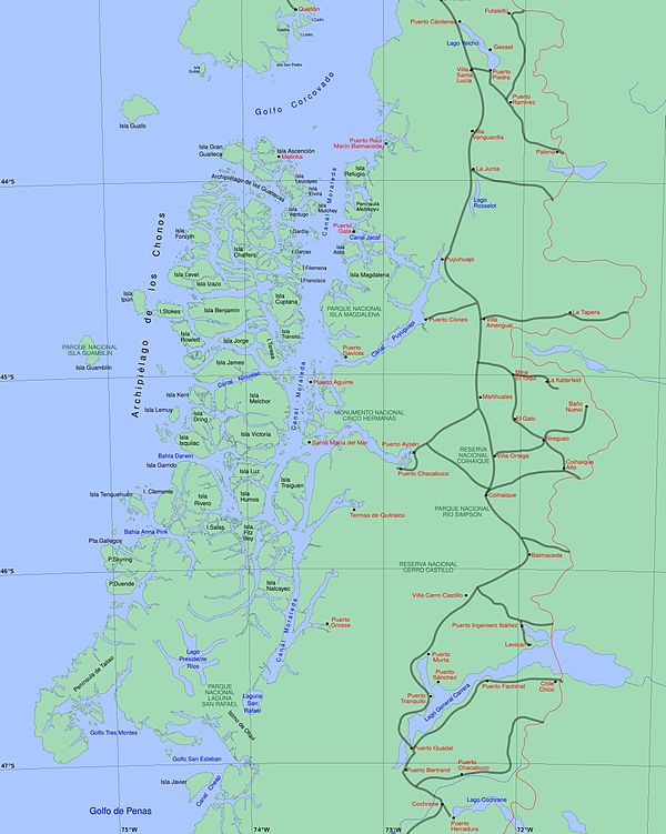
Beagle Channel is a strait in Tierra del Fuego Archipelago on the extreme southern tip of South America between Chile and Argentina. The channel separates the larger main island of Isla Grande de Tierra del Fuego from various smaller islands including the islands of Picton, Lennox and Nueva; Navarino; Hoste; Londonderry; and Stewart. The channel's eastern area forms part of the border between Chile and Argentina and the western area is entirely within Chile.
Walney Island, also known as the Isle of Walney, is an island off the west coast of England, at the western end of Morecambe Bay in the Irish Sea. It is part of Barrow-in-Furness, separated from the mainland by Walney Channel, which is spanned by the Jubilee Bridge. Walney is the largest island of the Furness Islands group, both in population and size, as well as the largest English island in the Irish Sea. Its population at the 2011 UK Census was 10,651, distributed evenly across the island's two Wards of Walney North and Walney South.

Lake Wawasee, formerly Turkey Lake, is a natural lake southeast of Syracuse in Kosciusko County, Indiana, United States. It is the largest natural lake wholly contained within Indiana. It is located just east of Indiana State Road 13.

Shirley Island is a rocky island lying 200 m (220 yd) north-west of the western end of the Bailey Peninsula, in the Windmill Islands of the Budd Coast, Wilkes Land, Antarctica. It is mostly ice-free with undulating, rocky terrain. It was first mapped from aerial photos taken by the USN's Operation Highjump in February 1947. It was named by the US-ACAN for Q. Shirley, chief photographer's mate on Operation Highjump photographic flights in coastal areas between 14° and 164° E longitude. Kirkby Shoal is a small shoal area with depths of less than 18 meters (59 ft) extending about 140 meters (459 ft) westwards and south-south-west, about 3.4 km (2.1 mi) from the summit of Shirley Island. Launch Channel is the narrow body of water between Bailey Peninsula and the island; with the relatively shallow soundings in the channel restricting its use to smaller craft and suggesting the name.

Tsing Yi Peak or Sam Chi Heung (三支香) is a hill with three peaks occupying the southern half of the Tsing Yi Island, Hong Kong. The hill is situated on the western half of Victoria Harbour. Its peaks are good locations to observe the harbour and the channels among harbour islands. While situated in the south, a short hill Liu To Shan occupies the northwest of the island.

Johnstone Strait is a 110 km (68 mi) channel along the north east coast of Vancouver Island in British Columbia, Canada. Opposite the Vancouver Island coast, running north to south, are Hanson Island, West Cracroft Island, the mainland British Columbia Coast, Hardwicke Island, West Thurlow Island and East Thurlow Island. At that point, the strait meets Discovery Passage which connects to Georgia Strait.

Sutil Channel is a broad strait located in the Discovery Islands of British Columbia, Canada.

Skidegate Channel is a strait located in the Haida Gwaii archipelago of British Columbia, Canada. It divides the archipelago's two main islands, Graham Island to the north and Moresby Island to the south.

The Parry Channel is a natural waterway through the central Canadian Arctic Archipelago. Its eastern two-thirds lies in the territory of Nunavut, while its western third lies in the Northwest Territories. It runs east to west, connecting Baffin Bay in the east with the Beaufort Sea in the west. Its eastern end is the only practical entrance to the Northwest Passage. Its western end would be a natural exit from the archipelago were it not filled with ice. The channel separates the Queen Elizabeth Islands to the north from the rest of Nunavut.

Trincomali Channel is a channel located in the Gulf Islands of British Columbia, Canada.