
Sri Jayawardenepura Kotte, commonly known as Kotte, is the legislative capital of Sri Lanka. Sri Jayawardenepura Kotte is located adjacent to the urban area of Sri Lanka's de facto economic, executive, and judicial capital, Colombo.

Kegalle is a large town in Sabaragamuwa Province of Sri Lanka. It is located on the Colombo–Kandy road, approximately 78 km (48 mi) from Colombo, 40 km (25 mi) from Kandy, 32 km (20 mi) from Kurunegala and 46 km (29 mi) from Avissavella. It is the main town in the Kegalle District, which is one of two districts which comprise Sabaragamuwa Province. The town is governed by an Urban Council.

North Western Province is a province of Sri Lanka. It is the fourth-largest province by land area, covering 7,888 km2 (3,046 sq mi), and the fourth-most populated province with a population of over 2,592,000 people. North Western Province is bordered by the North Central Province, Sri Lanka to the north, Central Province, Sri Lanka to the east, Sabaragamuwa Province to the southeast, Western Province, Sri Lanka to the south, and is bounded by the Indian Ocean to the west.

Kurunegala is a major city in Sri Lanka. It is the capital city of the North Western Province and the Kurunegala District. Kurunegala was an ancient royal capital for 50 years, from the end of the 13th century to the start of the 14th century. It is at the junction of several main roads linking to other important parts of the country. It is about 94 kilometres (58 mi) from Colombo, 42 kilometres (26 mi) from Kandy and 51 kilometres (32 mi) from Matale.

Gampaha is an urban city in Gampaha District, Western Province, Sri Lanka. It is situated to the north-east of the capital Colombo. It is the sixth largest urban area in Western Province, after Colombo, Negombo, Kalutara, Panadura and Avissawella. Gampaha is also the second largest municipal centre in Gampaha district, after Negombo. Gampaha has a land area of 25.8 ha and is home to the offices of 75 government institutions.

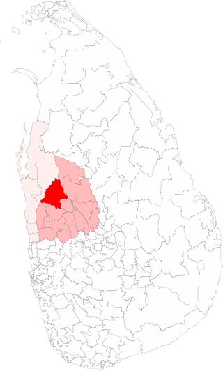
Kurunegala is a district in North Western Province, Sri Lanka. The district is 4,812.7 km2 (1,858.2 sq mi). It consists of thirty divisional secretariats, 1,610 grama niladari divisions and 4,476 villages. It has fourteen electoral divisions, two municipal councils, nineteen urban councils, fifteen members of parliament, 47 provincial council members, fifteen ministers and 337 local council members.

Puttalam is a district of Sri Lanka situated near the west coast of the country. The district has an area of 3,072 km2 (1,186 sq mi). Along with the Kurunegala District, it forms the North Western Province of Sri Lanka. The district capital is Puttalam, which borders the Kala Oya and Modaragam Aru in the north, Anuradhapura District and Kurunegala District in the east, Ma Oya in the south, and the Indian Ocean in the west. Puttalam has lagoons, popular for shallow sea fishing and prawn farming activities.

Negombo is a major city in Sri Lanka, situated on the west coast and at the mouth of the Negombo Lagoon, in the Western Province, 38 km (24 mi) from Colombo via the Colombo–Katunayake Expressway and the nearest major city from the Bandaranaike International Airport.

Maliyadeva College is a national school controlled by the Sri Lankan central government. It is located in Kurunegala, Sri Lanka, and was established in 1888 by the Buddhist Theosophical Society, led by Colonel Henry Steel Olcott. It is one of Sri Lanka's oldest schools. Today, the school accommodates 4,000 students. The term "Devans" is used to refer to the former and present pupils of Maliyadeva College.
Kuliyapitiya is the second largest town in Kurunegala District, North Western Province, Sri Lanka, governed by an Urban Council. It is located 82 kilometres (51 mi) north-east of Colombo and 38 kilometres (24 mi) from Kurunegala. Kuliyapitiya is home to the Wayamba University of Sri Lanka. Coconut and paddy cultivation are the main economic activities in this area. The town centre includes commerce and retail enterprises.
Ambalantota is a coastal town in southern Sri Lanka. It is located in Southern Province in Hambantota District between Matara and Hambantota.
Wariyapola (වාරියපොල) is a town in the Kurunegala District, North Western province, Sri Lanka. Wariyapola is 94 metres (308 ft) above the sea level. Wariyapola is mostly known by sri Lankans because of the Wariyapola Sri Sumangala Tero, who take down the Union Jack and re-hoisting the Sinhalese lion flag, before the convention that handed over control of the island to the British in 1815.
Nikaweratiya Divisional Secretariat is a Divisional Secretariat of Kurunegala District, of North Western Province, Sri Lanka.
Mawathagama is a town in the Kurunegala District, North Western Province of Sri Lanka. It is the third most developed city in Kurunegala District. It is situated 12 km (7.5 mi) from Kurunegala and 30 km (19 mi) from Kandy. It is home to over 75,000 people. 30% of them are age 0-18. Mawathagama is one of the most economically and politically important cities in North Western Province of Sri Lanka. It is an education and industrial hub for numerous people. Mawathagama Export Processing Zone is the largest industrial complex in the region

Panduwasnuwara is an ancient capital, situated in Kurunegala District, Sri Lanka. It is said to be the controlling centre known as Parakramapura of Dakkhinadesa in the 12th century, when it was ruled by Parakramabahu. The remaining ruins of the ancient kingdom still can be seen at Kotampitiya area which lies along Wariyapola-Chilaw main road about 19 km (12 mi) away from Wariyapola town. Panduvasnuwara is located at a distance of 3 km from Hettipola and 18 km from Kuliyapitiya.
Passara is a town in Badulla District, Uva Province of Sri Lanka. The town is located on Peradeniya-Badulla-Chenkalady main road, approximately 18 km (11 mi) away from Badulla City.
Alawwa is a town and divisional secretariat of the Kurunegala District in the North Western Province of Sri Lanka. The town is considered part of the Coconut Triangle, where most of the country's coconut exports come from. The population was 63,667 according to the 2012 Sri Lankan census.
Viharagama Grama Niladhari Division is a Grama Niladhari Division of the Nikaweratiya Divisional Secretariat of Kurunegala District of North Western Province, Sri Lanka. It has Grama Niladhari Division Code 295.
Hathigammana Grama Niladhari Division is a Grama Niladhari Division of the Nikaweratiya Divisional Secretariat of Kurunegala District of North Western Province, Sri Lanka. It has Grama Niladhari Division Code 305.
The Nikaweratiya Polling Division is a Polling Division in the Kurunegala Electoral District, in the North Western Province, Sri Lanka.
