
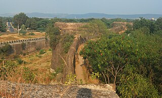
Ahmednagar is a city in Ahmednagar district in the state of Maharashtra, India, about 120 km northeast of Pune and 114 km from Aurangabad. Ahmednagar takes its name from Ahmad Nizam Shah I, who founded the town in 1494 on the site of a battlefield where he won a battle against superior Bahamani forces. It was close to the site of the village of Bhingar. With the breakup of the Bahmani Sultanate, Ahmad established a new sultanate in Ahmednagar, also known as Nizam Shahi dynasty.
Ahmednagar district is the largest district of Maharashtra state in western India. The historical Ahmednagar city is the headquarters of the district. Ahmednagar was the seat of the Ahmednagar Sultanate of late medieval period. This district is known for the towns of Shirdi associated with Sai Baba, Meherabad associated with Meher Baba, Shani Shinganapur with Shanidev, and Devgad with Lord Dattatreya. Ahmednagar district is part of Nashik Division. The district is bordered by Aurangabad district to the northeast, Nashik district to the northwest, Thane and Pune districts to the southwest, Solapur district to the south and Beed district to the southeast. Ahmednagar and Sangamner are largest cities in the district.
Yawal is a taluka, city and a municipal council in Jalgaon, Maharashtra, India.
Peth is the smallest tehsil of Nashik subdivision of Nashik district in Maharashtra, India. It belongs to Northern Maharashtra region. It belongs to Nashik Division. Peth is a Taluka headquarter. It is located 54 km to the West of District headquarters Nashik. It is also called as Peth. Peth Pin code is 422208 and postal head office is Peth.
State Highway 10, commonly referred to as MH SH 10, is a normal state highway that runs south through Pune, Ahmednagar, Nashik and Dhule districts in the state of Maharashtra, India. This state highway touches the cities of Dondaicha, Shevade, Mehergaon, Kusumbe, Malegaon, Manmad, Yeola, Kopargaon, Shirdi Rahata, Rahuri, Ahmednagar, Kashti, and Daund.
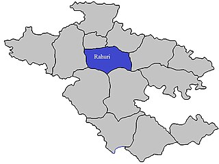
Rahuri taluka, is a taluka in the Shrirampur subdivision of the Ahmednagar district in Maharashtra, India.
Renwadi is a village in Parner taluka in Ahmednagar district of state of Maharashtra, India. According to Census 2011 information the location code or village code of Renwadi village is 558343. Renwadi village is located in Parner taluka of Ahmednagar district in Maharashtra, India. It is situated 36km away from sub-district headquarter Parner and 41km away from district headquarter Ahmadnagar. As per 2009 stats, Renawadi is the gram panchayat of Renwadi village.
Shirapur is a village in Parner taluka in Ahmednagar district of state of Maharashtra, India.

Khodad is a town in the Pune district of Maharashtra state, India. Khodad Village is situated in Junner taluka of Pune district of Maharashtra state, India. It is famous for Giant Metrewave Radio Telescope (GMRT), the largest telescope at metre wavelengths in the world, which attracts radio astronomers from different countries. Khodad is located on Junner & Ambegao taluka border. Khodad is surrounded by Junnar Taluka towards west, Khed Taluka towards South, Parner & Ambegaon Taluka towards East, Shirur Taluka towards North.
Kashi is a panchayat village in the state of Maharashtra, India, on the left (east) bank of the Ghod River, across the river from the village of Tandali. Administratively, Kasti is under Shrigonda Taluka of Ahmadnagar District in Maharashtra. There is only the single village of Kasti in the Kashti gram panchayat. The railroad station is 5 km by road south of the village. Kasti is 16 km by road southwest of the town of Shrigonda, and 14 km by road north of the town of Daund.
According to Census 2011 information the location code or village code of Itade village is 552635. Itade village is located in Bhiwandi Tehsil of Thane district in Maharashtra, India. It is situated 15km away from sub-district headquarter Bhiwandi and 38km away from district headquarter Thane. In the year 2020 Kirwali Tarfe Sonale is the gram panchayat of Itade village. Jagdish Madhukar Patil is the newly elected Sarpanch of the Gram Panchayat.
Manwath Road is a village in Manwath taluka of Parbhani district of Indian state of Maharashtra. Village is mainly known for being a major railway station on Nanded-Aurangabad rail route. Station code of Manwath road is MVO. It is 8 km away from taluka headquarter Manwath.
Kingaon is a village in Yawal taluka of Jalgaon district, Maharashtra, India. It is located between the foot hill of Satpura mountain and the bank of Tapti River. Kingaon is 25 km from the city of Jalgaon. Majority of the population consisting of farmers with banana & onion as the major product.
Bhadane is a village in the Murbad taluka of Thane district in Maharashtra, India.
Pilode is a village and located in Amalner Tehsil of Jalgaon district in Maharashtra, India. It is situated 10 km away from sub-district headquarter Amalner and 65 km away from district headquarter Jalgaon.
Chinchpur is a village located in the Taluka of Motala, in Buldhana district, Maharashtra, India, with a total population of 1292.
Kharshinde village is located in Sangamner Tehsil of Ahmadnagar district in Maharashtra, India. It is situated 38km away from sub-district headquarter Sangamner and 80km away from district headquarter Ahmadnagar. As per 2009 stats, Kharshinde village is also a gram panchayat. The total geographical area of village is 899.42 hectares. Kharshinde has a total population of 1,155 peoples. There are about 228 houses in Kharshinde village. As per 2019 stats, Kharshinde villages comes under Sangamner assembly & Shirdi parliamentary constituency. Sangamner is nearest town to Kharshinde which is approximately 38km away.
Kharadi village is located in Sangamner Tehsil of Ahmadnagar district in Maharashtra, India. It is situated 7km away from sub-district headquarter Sangamner and 105km away from district headquarter Ahmadnagar. As per 2009 stats, Kharadi village is also a gram panchayat. The total geographical area of village is 558.25 hectares. Kharadi has a total population of 2,036 peoples. There are about 385 houses in Kharadi village. As per 2019 stats, Kharadi villages comes under Sangamner assembly & Shirdi parliamentary constituency. Sangamner is nearest town to Kharadi which is approximately 7km away.
Konchi is a small Village/hamlet in Sangamner Taluka in Ahmednagar District of Maharashtra State, India. It comes under Konchi Panchayath. It belongs to Khandesh and Northern Maharashtra region. It belongs to Nashik Division. It is located 79 KM towards North from District head quarters Ahmednagar. 16 KM from Sangamner. 197 KM from State capital Mumbai.
Kuran village is located in Sangamner Tehsil of Ahmadnagar district in Maharashtra, India. The pincode of this place is 422605. It is situated 6km away from sub-district headquarter Sangamner and 105 km away from district headquarter Ahmadnagar. As per 2009 stats, Kuran village is also a gram panchayat. The total geographical area of the village is 1073 hectares. Kuran has a total population of 4,417 peoples of which 2313 are males while 2104 are females as per Population Census 2011. There are about 670 houses in Kuran village. As per 2019 stats, Kuran villages come under the Sangamner assembly & Shirdi parliamentary constituency. Sangamner is the nearest town to Kuran which is approximately 6km away.
