
Osmanabad District, officially known as Dharashiv District, is an administrative district in the Marathwada region in the Indian state of Maharashtra. The district headquarter is located at Osmanabad. The District of Osmanabad derives its name from the last ruler of Hyderabad, the 7th Nizam, Mir Osman Ali Khan, of which the region was a part till 1947. This region was earlier part of The Hyderabad State until Independence.This primarily rural district occupies an area of 7,569 km2 (2,922 sq mi) of which 241.4 km2 (93.2 sq mi) is urban and has a population of 1,657,576 of which 16.96% were urban.

The Bhima River is a major river in Western India and South India. It flows southeast for 861 kilometres (535 mi) through Maharashtra, Karnataka, and Telangana states, before joining the Krishna River. After the first sixty-five kilometers in a narrow valley through rugged terrain, the banks open up and form a fertile agricultural area which is densely populated.
Malshiras is a town and the headquarters of Malshiras taluka in Solapur district of Maharashtra state in western India. Its governing body is promoted to Nagar Panchayat from a Gram Panchayat in 2017. There are many popular towns in Malshiras taluka such as Akluj, Natepute, Mahalung, Malinagar, Velapur and popular Villages like Rajapur (Islampur) Goradwadi, Bhamburdi, Medad and Palasmandal. Rajapur (Islampur) is adjacent to Malshiras which has good literacy rate and having historic samadhi mandir of Veer Santaji Ghorpade.

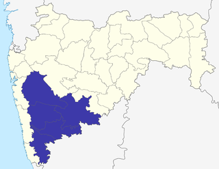
Pune district is a district in Western Maharashtra with Administrative Headquarters in Pune city. Pune district is the most populous district in the Indian state of Maharashtra. It is one of the most industrialised districts in India.
Pune Division is one of the six administrative divisions of the Indian State of Maharashtra. Pune Division is bound by Konkan Division to the west, Nashik Division to the north, Aurangabad Division to the east, and the state of Karnataka to the south.
Tuljapur is a town with a municipal council in Dharashiv district in the Indian state of Maharashtra. It is the administrative seat of Tuljapur taluka.
Indapur is a town and a municipal council in Pune district in the Indian state of Maharashtra. Indapur is known for Jahagir of Chhatrapati Shivaji Maharaj's father and grandfather. Chhatrapati Shivaji Maharaj's grandfather Malojiraje died in battle in Indapur.
Akluj is a town on the banks of Nira in Solapur district, Maharashtra, India. Akluj was earlier known for its large trade in cotton, which has almost disappeared at present. It is on the bank of River Nira. The town and surrounding area is agriculturally rich. Former deputy chief minister of Maharashtra, Vijaysinh Mohite–Patil was the sarpanch of Akluj.
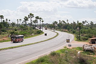
National Highway 65, , is a National Highway in India. It runs along the states of Maharashtra, Karnataka, Telangana and Andhra Pradesh. It starts at Pune and ends at Machilipatnam. Major cities on this route are Pune, Solapur, Hyderabad, Suryapet, Vijayawada and Machilipatnam. The section between Hyderabad and Vijayawada, is known as Vijayawada–Hyderabad Expressway and is a major expressway.

Nira is a river flowing through the Indian state of Maharashtra. It is a tributary of the Bhima river and flows through Pune and Solapur districts of Maharashtra. Karha is a tributary of Nira.
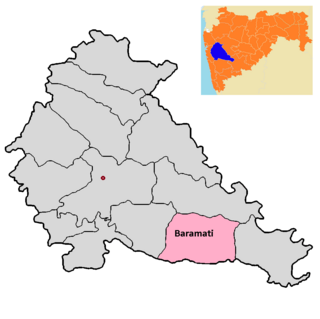
Baramati taluka is a taluka in Baramati subdivision of Pune district of state of Maharashtra in India.

Daund taluka is a taluka or subdivision of Pune district of the state of Maharashtra in India. The town of Daund is the only major urban area in this predominantly rural area. Daund railway station is a major railway junction. All southern railways are connected to this route, and also divided the Nagar railway to north Indian railway, like Delhi, Solapur division, Daund junction and then joined to the Pune district junction. To reach the Siddhi Vinayak Siddhatek Ganpati temple, one has to travel 14 km to Daund by road.

Indapur taluka is a taluka in Baramati subdivision of Pune district of state of Maharashtra in India.

The Shantinath Jain Teerth, also known as Shri 1008 Shantinath Digambar Jain Mandir, is a Jain temple located in Indapur, Pune, Maharashtra. The design and architecture of the temple is patterned after that of South Indian temples. The temple is known for its 27-foot tall granite idol of Shri 1008 Munisuvrata, the twentieth Tirthankara. The number 1008 is significant in Jainism and is associated with the Tirthankaras. The temple is sometimes called the Golden Temple because of its golden facade.
Umarga (Omerga) Tehsil is a tehsil/ taluka/ subdistrict in Osmanabad district, Maharashtra on the Deccan Plateau of India. The town of Umarga is the administrative headquarters of the tehsil. There are 79 panchayat villages in Umarga Tehsil.
Murum is a village and Gram Panchayat in Baramati Taluka in Pune District of Maharashtra State, India. It belongs to Desh or Paschim Maharashtra region. It is located 78 km south of District headquarters Pune. 34 km from Baramati.
Indapur Assembly constituency is one of the 288 Vidhan Sabha constituencies of Maharashtra state, western India. This constituency is located in Pune district, and is one of the 6 vidhan sabha seats which make up Baramati Lok Sabha seat.

Laul, also known as Sant Shri Kurmadas Maharaj Village, is a village located in Madha Taluka of Solapur District in the State of Maharashtra, in India. It belongs to the Pune Division. It is located 81 km towards west from District headquarter Solapur. It is situated from Kurduvadi Junction(6 km). The village is located at about 380 km from the state capital, Mumbai. Kurdu (5 km), Ghatane (6 km), Ujani Madha (6 km), Padsali (7 km), Ambad (Te) (7 km) are the nearby Villages to Laul. Laul is surrounded by Paranda Taluka towards North, Mohol Taluka towards East, Barshi Taluka towards East, Indapur Taluka towards west. Pandharpur, Kurduvadi, Solapur, Osmanabad are the nearby Cities to Laul. The village follows the Panchayati raj system. Also has a railway track, which used to travel by few people.

Shri Laxmi Narsimha Temple is a Hindu temple dedicated to Narasimha, an avatar of Vishnu, located in western India, in Pune district of the state of Maharashtra. The temple is located at the confluence of Bhima river and Nira river, at the south eastern tip of Pune district, in Indapur taluka.

