You can help expand this article with text translated from the corresponding article in Italian. (January 2022)Click [show] for important translation instructions.
|
Niscemi | |
|---|---|
| Comune di Niscemi | |
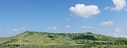 Niscemi skyline | |
 Coat of arms | |
 Niscemi Location of Niscemi in Italy 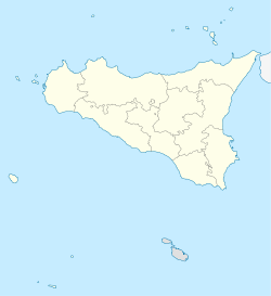 Niscemi Niscemi (Sicily) | |
| Coordinates: 37°09′N14°23′E / 37.150°N 14.383°E | |
| Country | Italy |
| Region | Sicily |
| Province | Caltanissetta |
| Government | |
| • Mayor | Massimiliano Valentino Conti |
| Area | |
• Total | 96 km2 (37 sq mi) |
| Elevation | 332 m (1,089 ft) |
| Population (October 31, 2025) [2] | |
• Total | 24,575 |
| • Density | 260/km2 (660/sq mi) |
| Demonym | Niscemesi |
| Time zone | UTC+1 (CET) |
| • Summer (DST) | UTC+2 (CEST) |
| Postal code | 93015 |
| Dialing code | 0933 |
| Patron saint | Maria Santissima del Bosco |
| Saint day | May 21 |
| Website | Official website |
Niscemi is a small city and comune in the free municipal consortium of Caltanissetta (Italian: libero consorzio comunale di Caltanissetta), Sicily, Italy. It has a population of 24,575 inhabitants. [3]
Contents
- Etymology
- Geography
- Territory
- History
- Foundation and Norman period
- Contemporary Age
- 2026 Landslide
- Monuments and places of interest
- Religious architecture
- Civil architecture
- Demographics
- Ethnic groups and foreign minorities
- Culture
- Education
- World War II
- American military installation
- See also
- Notable people
- References
- Citations
- Sources
- External links
The municipality is located in the Gela plain area and constitutes its north-eastern part in contact with the territory of Caltagirone. It is 90 km from Catania.


