
Ecuador is a country in western South America, bordering the Pacific Ocean at the Equator, for which the country is named. Ecuador encompasses a wide range of natural formations and climates, from the desert-like southern coast to the snowcapped peaks of the Andes mountain range to the plains of the Amazon Basin. Cotopaxi in Ecuador is one of the world's highest active volcanos. It also has a large series of rivers that follow the southern border and spill into the northwest area of Peru.

The geography of Italy includes the description of all the physical geographical elements of Italy. Italy, whose territory largely coincides with the homonymous geographical region, is located in southern Europe and comprises the long, boot-shaped Italian Peninsula crossed by the Apennines, the southern side of Alps, the large plain of the Po Valley and some islands including Sicily and Sardinia. Italy is part of the Northern Hemisphere. Two of the Pelagie Islands are located on the African continent.

South Africa occupies the southern tip of Africa, its coastline stretching more than 2,850 kilometres from the desert border with Namibia on the Atlantic (western) coast southwards around the tip of Africa and then northeast to the border with Mozambique on the Indian Ocean. The low-lying coastal zone is narrow for much of that distance, soon giving way to a mountainous escarpment that separates the coast from the high inland plateau. In some places, notably the province of KwaZulu-Natal in the east, a greater distance separates the coast from the escarpment. Although much of the country is classified as semi-arid, it has considerable variation in climate as well as topography. The total land area is 1,220,813 km2 (471,359 sq mi). It has the 23rd largest Exclusive Economic Zone of 1,535,538 km2 (592,875 sq mi).
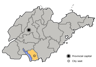
Zaozhuang is a prefecture-level city in the south of Shandong province, People's Republic of China. Since January 2019, the smallest prefecture-level city in the province, it borders Jining to the west and north, Linyi to the east, and the province of Jiangsu to the south. The Battle of Taierzhuang occurred in the city during the Second Sino-Japanese War in 1938. The Second Sino-Japanese War (1937–45) had a significant impact on Zaozhuang.

Pachino is a town and comune in the Province of Syracuse, Sicily (Italy). The name derives from the Latin word bacchus, which is the Roman god of wine, and the word vinum, which means wine in Latin; originally the town was named Bachino which eventually was changed to Pachino when, in Sicily, Italian became the official spoken and written language.

Prizzi is a town and comune of 5,711 inhabitants in the Italian Metropolitan City of Palermo, on the island of Sicily. It is located 84 km (52 mi) south of the city of Palermo at an altitude of 1045 m (3,428 ft) above sea level on a hill in the upper valley of the River Sosio. Prizzi is surrounded by the comuni of Campofelice di Fitalia, Castronovo di Sicilia, Lercara Friddi, Palazzo Adriano, Vicari, and the city of Corleone.

Vittoria is a town and comune in the province of Ragusa, Sicily, southern Italy. With its 64,212 inhabitants, Vittoria is the second most populated municipality of the province after Ragusa.

Chiaramonte Gulfi is a town and comune in the province of Ragusa, Sicily, southern Italy.
Rovasenda is a comune (municipality) in the Province of Vercelli in the Italian region Piedmont, located about 70 kilometres (43 mi) northeast of Turin and about 25 kilometres (16 mi) northwest of Vercelli. As of 31 December 2020, it had a population of 9,025 and an area of 29.3 square kilometres (11.3 sq mi).

Chiusa di Pesio is a comune (municipality) of 3,650 inhabitants in the Province of Cuneo in the Italian region Piedmont, located about 80 km south of Turin and about 15 km south-east of Cuneo, on the border with France.

Ovada is a comune (municipality) of 11,484 inhabitants in the Province of Alessandria in the northern Italian region Piedmont, located about 90 kilometres (56 mi) southeast of Turin and about 30 kilometres (19 mi) south of Alessandria.

Blufi is a comune (municipality) in the Metropolitan City of Palermo in the Italian region Sicily, located about 70 kilometres (43 mi) southeast of Palermo.

Santo Stefano Quisquina is a comune (municipality) in the Province of Agrigento in the Italian region Sicily, located about 60 kilometres (37 mi) south of Palermo and about 35 kilometres (22 mi) north of Agrigento.

Calatabiano is a comune (municipality) in the Metropolitan City of Catania in Sicily, southern Italy.

Escamilla is a municipality located in the province of Guadalajara, Castile-La Mancha, Spain. According to the 2004 census (INE), the municipality has a population of 108 inhabitants.
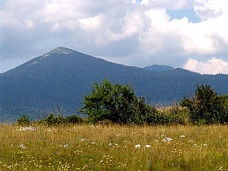
Šator is a mountain in the Dinaric Alps, in the western regions of Bosnia and Herzegovina. The name šator means "tent". The highest peak Veliki Šator is 1,872 m (6,142 ft) above sea level. Dimensions of the mountain are some 15 km in the west–east and 10 km in the north–south direction.
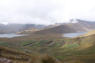
Alausí Canton is a canton in the Chimborazo Province in Ecuador. Its seat is Alausí. The canton is being promoted as a tourist region, and was named a Pueblo Mágico by the Ecuadorian Ministry of Tourism (MINTUR) in 2019.
Almoster is a village in the province of Tarragona and autonomous community of Catalonia, Spain. According to the 2008 census, its population was of 1,339 inhabitants.
Dotzlar is a district of Bad Berleburg in the district Siegen-Wittgenstein in North Rhine-Westphalia.

The topographical relief of Spain is characterized by being quite high, with an average altitude of 660 meters above sea level, quite mountainous compared to other European countries and only surpassed by Switzerland, Austria, Greece and the microstates of Andorra and Liechtenstein. In peninsular Spain, the terrain is articulated around a large Meseta Central that occupies most of the center of the Iberian Peninsula. Outside the plateau, there is the depression of the Guadalquivir river, located in the southwest of the peninsula, and the Ebro river depression, located in the northeast.


