No. 2 Strip Milne Bay

Last updated
No. 2 Strip Milne Bay
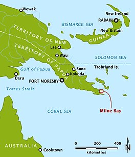
MilneBayLocation.jpg
Location of No. 2 Strip Milne Bay
Papua New Guinea relief map.svg
Red pog.svg
No. 2 Strip Milne Bay
Location Milne Bay Province
Coordinates 10°19′00″S150°15′00″E / 10.316667°S 150.25°E / -10.316667; 150.25
SettlementsFlag of the United States Navy (official).svg  United States Navy
Naval Base Milne Bay
1942
Enlargement of Milne Bay, indicating No. 2 Strip Milne Bay locations. Area of Battle of Milne Bay 1942.jpg
Enlargement of Milne Bay, indicating No. 2 Strip Milne Bay locations.

No. 2 Strip Milne Bay, (Waigani Airfield), was an aerodrome under construction near Waigani village, Milne Bay, Papua New Guinea during World War II as part of Naval Base Milne Bay.

Works at the aerodrome were discontinued due to the site being unsuitable for an aerodrome due to drainage problems. Airfield was at 10°19′00″S150°15′00″E / 10.316667°S 150.25°E / -10.316667; 150.25 . [1] [2] [3] [4]

Related Research Articles

<span class="mw-page-title-main">Milne Bay Province</span> Province in Papua New Guinea

Milne Bay is a province of Papua New Guinea. Its capital is Alotau. The province covers 14,345 km2 of land and 252,990 km2 of sea, within the province there are more than 600 islands, about 160 of which are inhabited. The province has about 276,000 inhabitants, speaking about 48 languages, most of which belong to the Eastern Malayo-Polynesian branch of the Austronesian language family. Economically the province is dependent upon tourism, oil palm, and gold mining on Misima Island; in addition to these larger industries there are many small-scale village projects in cocoa and copra cultivation. The World War II Battle of Milne Bay took place in the province.

<span class="mw-page-title-main">Kiriwina</span> Island of Papua New Guinea

Kiriwina is the largest of the Trobriand Islands, with an area of 290.5 km2 (112.2 sq mi). It is part of the Milne Bay Province of Papua New Guinea. Most of the 12,000 people who live in the Trobriands live on Kiriwina. The Kilivila language, also known as Kiriwina, is spoken on the island. The main town is Losuia. The island falls under the administrative division of Kiriwina Rural LLG.

<span class="mw-page-title-main">Goodenough Island</span> Island in Papua New Guinea

Goodenough Island in the Solomon Sea, also known as Nidula Island, is the westernmost of the three large islands of the D'Entrecasteaux Islands in Milne Bay Province of Papua New Guinea. It lies to the east of mainland New Guinea and southwest of the Trobriand Islands. It is roughly circular in shape, measuring 39 by 26 kilometres with an area of 687 square kilometres (265 sq mi) and a shoreline of 116 kilometres (72 mi). A coastal belt varying in width from 2 to 10 kilometres is covered in grasslands and dissected by streams and coastal swamps. The island rises sharply to the summit of Mount Vineuo, 2,536 metres (8,320 ft) above sea level, making it one of the most precipitous islands in the world. The small outlier Wagifa Island lies to the south-east of the island, and is included within Goodenough's administration.

<span class="mw-page-title-main">Port Moresby International Airport</span> Airport in Saraga, Port Moresby, Papua New Guinea

Port Moresby International Airport, also known as Jacksons International Airport, is an international airport located eight kilometres outside Port Moresby in Papua New Guinea. It is the largest and busiest airport in Papua New Guinea, with an estimated 1.4 million passengers using the airport in 2015, and is the main hub for Air Niugini, the national airline of Papua New Guinea. The airport serves as the main hub for PNG Air and Travel Air. It replaced the original Port Moresby airport, in what is now the suburb of Waigani, whose airstrip remained until the 1990s but no trace of which remains, having been built over.

<span class="mw-page-title-main">Gurney Airport</span> Airport in Milne Bay, Papua New Guinea

Gurney Airport is an airport serving Alotau in the Milne Bay Province of Papua New Guinea (PNG).

<span class="mw-page-title-main">Cape Sudest</span> Southeastern Papua New Guinea cape

Cape Sudest is a cape in Papua New Guinea, next to Oro Bay. Cape Sudest is a remote and rugged peninsula located in the southeastern part of Papua New Guinea. It is situated in the Ijivitari District of the Milne Bay Province, which is one of the 22 provinces of Papua New Guinea. The Cape Sudest peninsula is surrounded by the Solomon Sea on the east and the Coral Sea on the south, and it is characterized by steep cliffs, dense rainforests, and pristine beaches.

<span class="mw-page-title-main">Turnbull Field</span> Aerodrome in Papua New Guinea

Turnbull Field was an aerodrome near Gili Gili, Papua New Guinea.

<span class="mw-page-title-main">Samarai Advanced Seaplane Base</span> World War 2 Seaplane base

Samarai Advanced Seaplane Base was a US Navy seaplane base at Samarai Island, Papua New Guinea during World War II.

Wards Airfield is a former World War II airfield near Port Moresby, Papua New Guinea. The airfield was abandoned after the war and was developed into the Waigani area of Port Moresby.

Durand Airfield is a former World War II airfield near Port Moresby, Papua New Guinea. It was part of a multiple-airfield complex in the Port Moresby area, located 17 miles (27 km) from Port Moresby, to the north of the Waigani swamp.

HMAS <i>Ladava</i> (naval base)

HMAS Ladava is a former Royal Australian Navy (RAN) base that was located at Milne Bay in Papua New Guinea.

Kara is a town in southern Bougainville in Papua New Guinea, north of Buin. Buin Airport, formerly known as Kara Airfield, is situated nearby.

<span class="mw-page-title-main">Naval Base Milne Bay</span> Major World War 2 base in Papua New Guinea

Naval Base Milne Bay, also called Naval Advance Base Milne Bay, was new major United States Navy sea and airbase base built on Milne Bay in Milne Bay Province in south-eastern Papua New Guinea. By spring 1943, the build up of the US Navy to support the Pacific War had caused overcrowding at the ports on the east coast of Australia. To help, Seabees departed Naval Base Brisbane on June 19, 1943 to set up a new base in Milne Bay. Naval Base Milne Bay headquarters was at Ladava Navy Base. The Royal Australian Navy already had a small base in Milne Bay: HMAS Ladava. Australians were able to defend and keep Milne Bay in the Battle of Milne Bay in 1942. Naval Base Milne Bay was built during World War II to support the many ships and aircraft fighting and patrolling in the South West Pacific theatre of war. Ladava Navy Base provided a large protective US Navy fleet anchorage at Gahora Bay next to Ladava. At Naval Base Milne Bay, Seabees built a large Naval facility.

<span class="mw-page-title-main">Naval Base Manus</span> Major US Navy Base on Manus Island, Papua New Guinea

Manus Naval Base was a number of bases built after the World War II Battle of Manus by United States Navy on the Manus Island and a smaller island just east, Los Negros Island in the Admiralty Islands chain. The major naval base construction started with the Los Negros landings on February 28, 1944. The Navy repaired and did the expansion of the airfields on the Admiralty Islands. United States Navy Seabee built or repaired the facilities on the islands. The large Manus Naval Base, also called the Admiralty Island base, supported United States Seventh Fleet, Southwest Pacific command, and part of the Pacific Fleet. The base was abandoned by the US Navy after the war.

<span class="mw-page-title-main">Naval Base Brisbane</span> Major World War 2 base in Australia

Naval Base Brisbane was a major United States Navy base built in the early part of World War II at Brisbane, Queensland, Australia. At first, operated as a base for patrol aircraft and convoy escort aircraft to protect the last leg of the Pacific War to the Southwest Pacific. As the US Navy expanded in the island hopping campaign, Naval Base Brisbane expanded to include a submarine base, repair depot, seaplane base and other facilities. US Navy operations started on April 14, 1942, and ended after the war in 1945.

<span class="mw-page-title-main">Naval Base Merauke</span> Major World War 2 base in New Guinea

Naval Base Merauke was a United States Navy base built during World War II at city of Merauke in the South Papua province of Indonesia, then Dutch New Guinea. The base was 2 miles from the mouth of the Merauke River. The US Navy built a PT boat base and base dock with anchorage to support the Pacific War and the New Guinea campaign.

<span class="mw-page-title-main">Naval Base Port Moresby</span> World War 2 base in Papua New Guinea

Naval Base Port Moresby was a United States Navy base built during World War II at the city of Port Moresby on Papua New Guinea. The US Navy built a communication center and advance base headquarters for the US Seventh Fleet to support the Pacific War in 1943. The base was part of the New Guinea campaign.

<span class="mw-page-title-main">Naval Base Woodlark Island</span> World War 2 base in New Guinea

Naval Base Woodlark Island was a United States Navy base built during World War II on Woodlark Island on Papua New Guinea. The US Navy built a PT boat base, boat repair depot, and harbor facilities at the city of Guasopa to support the Pacific War in 1943. The Harbor facilities was also built to support the US Navy in building the Narewa Airfield on the island. The base was part of the New Guinea campaign.

<span class="mw-page-title-main">Naval Base Finschhafen</span> World War 2 base in New Guinea

Naval Base Finschhafen was a United States Navy base built during World War II at Finschhafen on the Huon Peninsula in Morobe Province of Papua New Guinea. The US Navy built a PT boat base, Dreger Harbor PT Boat Base, boat repair depot, and harbor facilities at Dreger Harbour and Langemak Bay to support the Pacific War in 1943. Harbor was also built to support the US Navy in building 6,000-foot Finschafen Airfield, also called Dreger Field, now Finschhafen Airport on the island. The base was part of the New Guinea campaign.

<span class="mw-page-title-main">US Naval Base New Guinea</span> Major World War 2 bases in Papua New Guinea

US Naval Base New Guinea was number of United States Navy bases on the island of New Guinea during World War II. Australia entered World War II on 3 September 1939, being a self-governing nation within the British Empire. The United States formally entered the war on 7 December 1941, following the attack on Pearl Harbor by the Empire of Japan. Following the attack on Pearl Harbor, Japan quickly took over much of the South Pacific Ocean. The United States lost key naval bases in the South Pacific, including Naval Base Manila and Naval Base Subic Bay, both lost in the 1941–42 invasion of the Philippines. Also lost were Naval Base Guam and Wake Atoll. As such, the United States Armed Forces needed new bases in the South West Pacific for staging attacks on Japan's southern empire. The United States built bases first in Australia, then in New Guinea.

References

  1. "Pacific Wrecks - Waigani Airfield (No. 2 Strip, Unnamed) Milne Bay Province, Papua New Guinea (PNG)". pacificwrecks.com.
  2. "Pacific Wrecks". pacificwrecks.com.
  3. "Pacific War Airfields Project". Archived from the original on 2011-07-15. Retrieved 2008-08-27.
  4. "Building the Navy's Bases, vol. 2 (part III, chapter 26)". NHHC.