North Korea is located in East Asia on the Northern half of the Korean Peninsula.

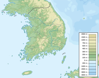
South Korea is located in East Asia, on the southern half of the Korean Peninsula jutting out from the far east of the Asian landmass. The only country with a land border to South Korea is North Korea, lying to the north with 238 kilometres (148 mi) of border running along the Korean Demilitarized Zone. South Korea is mostly surrounded by water and has 2,413 kilometres (1,499 mi) of coastline along three seas; to the west is the Yellow Sea, to the south is the East China Sea, and to the east is the Sea of Japan. Geographically, South Korea's land mass is approximately 100,032 square kilometres (38,623 sq mi). 290 square kilometres (110 sq mi) of South Korea are occupied by water. The approximate coordinates are 37° North, 127° 30 East.

Paektu Mountain or Baekdu Mountain is an active volcano on the Chinese–North Korean border. At 2,744 m (9,003 ft), it is the highest mountain of the Changbai and Baekdudaegan ranges. Koreans assign a mythical quality to the volcano and its caldera lake, considering it to be their country's spiritual home. In China the mountain is called Changbai Mountain. It is the highest mountain on the Korean Peninsula and in Northeast China.

Goheonsan is a mountain in the vicinity of the city of Ulsan, South Korea. It has an elevation of 1,032 m (3,386 ft). It is part of the Yeongnam Alps mountain range.

Soyosan is a mountain in Gyeonggi-do, South Korea. Its area extends across the cities of Pocheon and Dongducheon. It has an elevation of 587 m (1,926 ft). The mountain is home to two Buddhist shrines commemorating Silla priests Wonhyo and Uisang, and a small temple called Jaja Hermitage. The mountain is famous for its small waterfalls and spring wells and is a popular hiking route.
Baegamsan is a mountain in the counties of Hongcheon and Inje, Gangwon-do in South Korea. It has an elevation of 1,099 m (3,606 ft).
Baekseoksan is a mountain in the county of Pyeongchang, Gangwon-do in South Korea. It has an elevation of 1,364.6 m (4,477 ft).
Boraebong is a mountain in the county of Pyeongchang, Gangwon-do in South Korea. It has an elevation of 1,324.3 m (4,345 ft).
Cheongoksan is a mountain in the county of Bonghwa, Gyeongsangbuk-do in South Korea. It has an elevation of 1,276.5 m (4,188 ft).
Daeamsan is a mountain in the province of Gangwon-do, South Korea. It sits on the boundary between the counties of Inje and Yanggu. Daeamsan has an elevation of 1,304 m (4,278 ft).
Deokhangsan is a mountain in Odaesan National Park in the county of Pyeongchang and the city of Gangneung, Gangwon-do in South Korea. It has an elevation of 1,433.5 m (4,703 ft).
Heungjeongsan is a mountain in the county of Pyeongchang, Gangwon-do in South Korea. It has an elevation of 1,276.5 m (4,188 ft).
Hoeryeongbong is a mountain in the county of Pyeongchang, Gangwon-do in South Korea. It has an elevation of 1,331 m (4,367 ft).
Maebongsan is a mountain in the county of Yeongwol, Gangwon-do in South Korea. It has an elevation of 1,267.6 m (4,159 ft).
Mireuksan is a mountain in the city of Wonju, Gangwon-do in South Korea. It has an elevation of 1,118.8 m (3,671 ft).
Munsubong is a South Korean mountain that sits between the city of Taebaek, Gangwon-do and the county of Bonghwa, Gyeongsangbuk-do. It has an elevation of 1,517 m (4,977 ft).
Seondalsan is a South Korean mountain that sits between the county of Yeongwol, Gangwon-do and Bonghwa, Gyeongsangbuk-do. It has an elevation of 1,236 m (4,055 ft).
Taehwasan is a South Korean mountain that sits between the county of Yeongwol, Gangwon-do and Danyang County, Chungcheongbuk-do. Its summit has an elevation of 1,027.4 m (3,371 ft).
Yukbaeksan is a mountain in the city of Samcheok, Gangwon-do in South Korea. It has an elevation of 1,244.6 m (4,083 ft).
Daemisan is a South Korean mountain between the cities of Jecheon, Chungcheongbuk-do and Mungyeong, Gyeongsangbuk-do. It has an elevation of 1,115 m (3,658 ft).


