
Mali is a landlocked nation in West Africa, located southwest of Algeria, extending south-west from the southern Sahara Desert through the Sahel to the Sudanian savanna zone. Mali's size is 1,240,192 square kilometers.
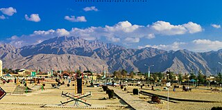
Quetta is the capital and largest city of the Pakistani province of Balochistan. It is the ninth largest city in Pakistan, with an estimated population of over 1.5 million in 2024. It is situated in the south-west of the country, lying in a valley surrounded by mountains on all sides. Quetta is at an average elevation of 1,680 metres above sea level, making it Pakistan's highest altitude major city. The city is known as the "Fruit Garden of Pakistan" due to the numerous fruit orchards in and around it and the large variety of fresh and dried fruits produced there.

The desert climate or arid climate is a dry climate sub-type in which there is a severe excess of evaporation over precipitation. The typically bald, rocky, or sandy surfaces in desert climates are dry and hold little moisture, quickly evaporating the already little rainfall they receive. Covering 14.2% of Earth's land area, hot deserts are the second-most common type of climate on Earth after the Polar climate.
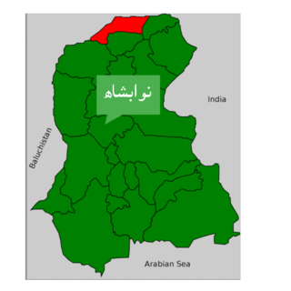
Nawabshah is a tehsil and headquarters of the Shaheed Benazirabad District of Sindh province, Pakistan. This city is situated in the middle of Sindh province. It is the 27th most populous city in Pakistan. Nawabshah Tehsil was established in 1903 by the British government. The tehsil was a part of Hyderabad district. On 1 November 1912, Nawabshah was upgraded to a district status of Sind Division.

Chumphon is a town in southern Thailand, capital of the Chumphon Province and Mueang Chumphon District. The city is about 463 kilometers from Bangkok. As of 2018 it had a population of around 33,600. The town covers the commune (tambon) Tha Taphao completely and parts of tambons Bang Mak, Wang Phai, Na Thung, Tak Daet, and Khun Krathing. Its main economic activity is agriculture.

Jiwani is a town and commercial port located on the Gulf of Oman in the Gwadar District of the Balochistan province of Pakistan. The town has a population of 25,000 and is expected to become a major commercial centre in concert with the development of the port city of Gwadar, located nearly 60 kilometres (37 mi) to the east.
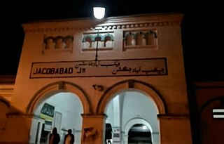
Jacobabad is a city in Sindh, Pakistan, serving as both the capital city of Jacobabad District and the administrative centre of Jacobabad Taluka, an administrative subdivision of the district. The city itself is subdivided into eight Union Councils. Sitting far to the northwest of the province, near the provincial boundaries of Sindh and Balochistan, Jacobabad became a city on the site of an existing village (Khangarh), and is crossed by the Pakistan Railways and many main roads of the province. It is the 43rd most populous city in Pakistan.
Karachi has a tropical semi arid climate, albeit a moderate version of this climate, influenced by monsoons. Karachi has a tropical climate, despite being located slightly above the Tropic of Cancer. It is situated in the monsoon region of Pakistan. It is located on the coast bordering the Arabian Sea, and as a result, has a relatively mild climate. However, in more recent years, rainfall has become more abundant, with annual rainfall projected to reach over 500 mm by 2100. For this reason, the city may be classed as almost semi-arid (BSh), since it has a mild climate with a short but defined wet season, along with a lengthy dry season.

Barkhan is the capital city of the Barkhan District in the Balochistan province of Pakistan. It is located at 29°54'0N 69°31'0E at an altitude of 1,100 metres (3,612 feet) above sea level.
Khuzdar is a city in the administrative headquarter of Khuzdar District in the central part of the Balochistan province of Pakistan. Khuzdar is the 3rd-largest city of the Balochistan province and the 48th-largest city of Pakistan by population, according to the 2017 census, and as of 2023 the estimated population is 997,214. Historically, Khuzdar was the main city and capital of the Jhalawan province of the Khanate of Kalat. From October 1952 to 1955, it became part of the Balochistan States Union. In 1955, Khuzdar became the capital of the newly formed Kalat Division before it became a district of its own in 1974.Gresha is the sub tehsil of khuzdar District and its almost 80Km from khuzdar city. As of 2017, it is the largest Brahui-speaking city.
Panjgur or Pangor, transliterated and misspelled in Arabic as Bannajbur or Fannazbur is a town in Panjgur District, Balochistan. It is renowned for its dates. The name drives its origins from blending of two Balochi words i.e "Panj" meaning five and "Goran" meaning highland, i.e land of 5 highlands. As the name suggests, Panjgur is situated 980 meters above sea level and constitutes the only highland of the Makran region. The origins of the word "Goran" are unclear but some scholars believe the name originates from the Avestan word gairi meaning mountain. Additionally, the presence of areas surrounding Panjgur carrying the name Goran, such as Chokgoran meaning "small highland" and Mazangoran "big highland" point to a possibly identical origin of the name. However, it is also contented that the name Panjgur might be a portmanteau of another two Balochi words i.e Panj and Goor meaning five graves. Panjgur district is known as one of the largest growing regions of Mazafti or Muzati dates, a high quality table date. Panjgur has of its lands under the Muzati harvest with estimates that Mazafati accounts for around 10% of Panjgur’s total revenues.

Zhob, formerly known as Mandokhail and Fort Sandeman is a city and district headquarters of the Zhob District in the Balochistan province of Pakistan. Zhob is located on the banks of the Zhob river. It lies 337 kilometres away from Quetta, the capital of Balochistan.
Dalbandin is a city and the headquarter of Chagai district in Pakistan's Balochistan province, near the Iran and Afghanistan border. The city has a population of 16,319, and the remainder of the entire Dalbandin Tehsil has a population of 110,503. It is located at an altitude of 843 m (2769 ft). Dalbandin is famous for its fruit orchards. Dalbandin city is surrounded by desert and mountains. An Afghan refugee camp is located on Dalbandin Chagai Road.
Khanpur is a city and capital of Khanpur Tehsil of the Rahim Yar Khan District, Bahawalpur Division, in the Punjab province of Pakistan.

Pakistan's climate varies from a continental type of climate in the north (Gilgit-Baltistan,Kashmir,KPK), a mountainous dry climate in the west (Baluchistan), a wet climate in the East (Punjab) an arid climate in the Thar Desert, to a tropical climate in the southeast (Sindh), characterized by extreme variations in temperature, both seasonally and daily, because it is located on a great landmass barely north of the Tropic of Cancer.
Lahore features a five-season semi-arid climate, bordering a humid subtropical climate, with five seasons: foggy winter with few western disturbances causing rain; pleasant spring ; summer with dust, rain storms and heat wave periods; rainy monsoon ; and dry autumn. However, in some cases, it can be classified as being humid subtropical (Cwa), rather than semi-arid, since it has well defined seasons and an ample amount of rain. It occasionally has very prolonged and dense monsoons, typical of a humid subtropical climate.
Quetta, Pakistan features a continental semi-arid climate with a large variation between summer and winter temperatures. The highest temperature recorded in Quetta was 42 °C (108 °F) on 10 July 1998. The lowest temperature in Quetta is −18.3 °C (−0.9 °F) which was recorded on 8 January 1970.

The 2022 India–Pakistan heat wave was an extreme weather event which resulted in the hottest March in the subcontinent since 1901. The hot season arrived unusually early in the year and extended into April, affecting a large part of India's northwest and Pakistan. The heatwave was combined with a drought, with rainfall being only a quarter to a third of normal. It occurred during a La Niña event, in which heat records are generally less likely.

