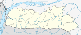
Meghalaya is a state in northeast India. Meghalaya was formed on 21 January 1972 by carving out two districts from the state of Assam: (a) the United Khasi Hills and Jaintia Hills and (b) the Garo Hills. The population of Meghalaya as of 2014 is estimated to be 3,211,474. Meghalaya covers an area of approximately 22,430 square kilometres, with a length-to-breadth ratio of about 3:1.

Shillong is a hill station and the capital of Meghalaya, a state in northeastern India. It is the headquarters of the East Khasi Hills district. Shillong is the 330th most populous city in India with a population of 143,229 according to the 2011 census. It is said that the rolling hills around the town reminded the British of Scotland. Hence, they would also refer to it as the "Scotland of the East".

The Khasi people are an ethnic group of Meghalaya in north-eastern India with a significant population in the bordering state of Assam, and in certain parts of Bangladesh. Khasi people form the majority of the population of the eastern part of Meghalaya, that is Khasi Hills, constituting 78.3% of the region's population, and is the state's largest community, with around 48% of the population of Meghalaya. They are among the few Austroasiatic-speaking peoples in South Asia. The Khasi tribe holds the distinction of being one of the few remaining matriarchal tribes of the world. Under the Constitution of India, the Khasis have been granted the status of Scheduled Tribe.

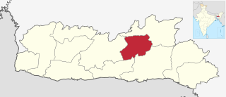
East Khasi Hills is an administrative district in the state of Meghalaya in India. The district headquarters are located at Shillong. The district occupies an area of 2752 km² and has a population of 825,922. As of 2011, it is the most populous district of Meghalaya's 12 districts.

Ri Bhoi is an administrative district in the state of Meghalaya in India. The district headquarters are located at Nongpoh. The district occupies an area of 2378 km² and has a population of 258,840. As of 2011 it is the second least populous district of Meghalaya, after South Garo Hills.

West Garo Hills is an administrative district in Garo Hills of the state of Meghalaya in India. Tura town is the administrative headquarters of the district. The district occupies an area of 3714 km². In 2011 its population was 643,291. As of 2011 it is the second most populous district of Meghalaya, after East Khasi Hills.

West Khasi Hills is an administrative district in the state of Meghalaya in India.
Nongstoin is the headquarters of West Khasi Hills district in the state of Meghalaya in India.
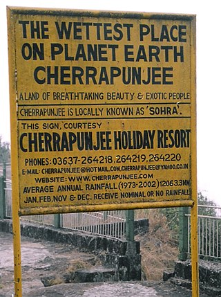
Cherrapunji or Sohra is a subdivisional town East Khasi Hills district in the Indian state of Meghalaya. It is the traditional capital of ka hima Sohra.

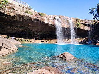
The Garo Hills are part of the Garo-Khasi range in Meghalaya, India. They are inhabited by the Garo people. It is one of the wettest places in the world. The range is part of the Meghalaya subtropical forests ecoregion.
The Khasi Hills is a low mountain formation on the Shillong Plateau in Meghalaya state of India. The Khasi Hills are part of the Garo-Khasi-Jaintia range and connects with the Purvanchal Range and larger Patkai Range further east. Khasi Hills, and the whole Garo-Khasi-Jaintia range, are in the Meghalaya subtropical forests ecoregion.

Jowai is the headquarters of the West Jaintia Hills district of the state of Meghalaya, India, and is home to the Pnar, a sub-tribe of the Khasi people. It is located on a plateau surrounded on three sides by the Myntdu river bordering Bangladesh to the south. Due to its high altitude of 1365 m above sea level, Jowai experiences warm summers with cool to chilly winters.
The Meghalaya subtropical forests is an ecoregion of Northeast India. The ecoregion covers an area of 41,700 square kilometers (16,100 sq mi), and despite its name, comprise not only the state of Meghalaya, but also parts of southern Assam, and a tiny bit of Nagaland around Dimapur and adjacent Bangladesh. It also contains many other habitats than subtropical forests, but the montane subtropical forests found in Meghalaya is an important biome, and was once much more widespread in the region, and for these reasons chosen as the most suitable name. The scientific designation is IM0126.
The Langshiang Falls is located near the village of Sangriang, 24 kilometres (15 mi) from Nongstoin, in West Khasi Hills district in the Indian state of Meghalaya. It can also be seen from Mawpon village.
West Jaintia Hills is an administrative District in the state of Meghalaya in India. The united district was created on 22 February 1972 and occupied an area of 3819 km2. It had a population of 272,185. The district is part of the Meghalaya subtropical forests eco-region. With the bifurcation of the erstwhile Jaintia Hills District into East and West Jaintia Hills Districts, West Jaintia Hills District came into existence on 31 July 2012 with its headquarters at Jowai. Jowai is the host of all the heads of important governmental offices and establishments, educational institutions, hospitals, banking institutions, etc.

A living root bridge is a type of simple suspension bridge formed of living plant roots by tree shaping. They are common in the southern part of the Indian state of Meghalaya. They are handmade from the aerial roots of rubber fig trees by the Khasi and Jaiñtia peoples of the mountainous terrain along the southern part of the Shillong Plateau. Most of the bridges grow on steep slopes of subtropical moist broadleaf forest between 50 and 1,150 m above sea level.

Northeast India consists of the eight states Arunachal Pradesh, Assam, Manipur, Meghalaya, Mizoram, Nagaland, Sikkim and Tripura. Tourism in this area is based around the unique Himalayan landscape and culture distinct from the rest of India.
The Republic of India shares borders with several sovereign countries; it shares land borders with China, Bhutan, Nepal, Pakistan, Afghanistan, Bangladesh and Myanmar. Bangladesh and Pakistan share both land borders as well as maritime borders, while Sri Lanka shares only a maritime border through Ram Setu. India's Andaman and Nicobar Islands share a maritime border with Thailand, Myanmar and Indonesia.

The Kulsi River is a tributary of the Brahmaputra River in the Indian state of Assam. The river originates from West Khasi Hills of Meghalaya. The Kulsi river is known as Khir River in its origin. After travelling 12 km in Meghalaya, this river then flows through Kamrup district of Assam and is known as Kulsi. The confluence of the Kulsi river with Brahmaputra River is at Nagarbera of Kamrup district, Assam.
Eastern West Khasi Hills is a district in the Indian state of Meghalaya, located approximately 25 kilometres (16 mi) west of the state capital of Shillong. It was created in 2021, after bifurcation of existing West Khasi Hills district. The territories which make up the district recorded a total population of 131,451 in the 2011 census. The district headquarters is the town of Mairang.