Noonday Water Reclamation Facility

Last updated

The Noonday Water Reclamation Facility is a sewage treatment plant that processes around 20 million gallons or 75 million liters of sewage per day for northeast Cobb and southern Cherokee counties in north-northwest metro Atlanta, located in north-central Georgia. It is operated by Cobb's water system, which partly wholesales its service to Cherokee's.

Gallon general topic for different units of volume called gallon

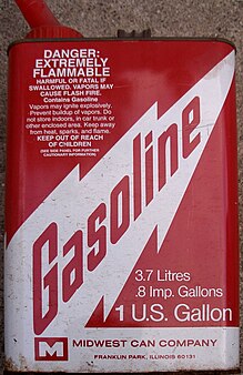
The gallon is a unit of measurement for volume and fluid capacity in both the US customary units and the British imperial systems of measurement. Three significantly different sizes are in current use: the imperial gallon defined as 4.54609 litres, which is used in the United Kingdom, Canada, and some Caribbean nations; the US gallon defined as 231 cubic inches or exactly 3.785411784 litres, which is used in the US and some Latin American and Caribbean countries; and the least-used US dry gallon defined as 1/8 US bushel (4.405 L).

Sewage Wastewater that is produced by a community of people

Sewage is a type of wastewater that is produced by a community of people. It is characterized by volume or rate of flow, physical condition, chemical and toxic constituents, and its bacteriologic status. It consists mostly of greywater, blackwater ; soaps and detergents; and toilet paper.

Cherokee County, Georgia County in the United States

Cherokee County is a county located in the US state of Georgia. As of the 2010 census, the population was 214,346. According to the local newspaper, the Cherokee Ledger-News on August 29, 2018, with an estimated population of 254,500, Cherokee is currently the fastest growing county in the metro Atlanta, Georgia area. The county seat is Canton. The county Board of Commissioners is the governing body, with members elected to office.

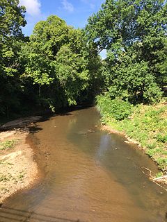
The facility is located just south of the county line and east of Interstate 575 at 415 Shallowford Road, east of Kennesaw, also serving part of Marietta and all of Woodstock, its nearest city. [1] This generally corresponds to the drainage basin of both Noonday Creek on which it is located, and Rubes Creek to the east, which is also a tributary of the Little River, in turn flowing northward into the Etowah River via Lake Allatoona.

Interstate 575 (I-575) is an Interstate Highway spur route in the United States, which branches off Interstate 75 in Kennesaw and connects the metro Atlanta area with the north Georgia mountains, extending 30.97 miles (49.84 km). I-575 is also the unsigned State Route 417 and is cosigned as SR 5. I-575 begins in northern Cobb County near Kennesaw and goes mostly through Cherokee County, ending at its northern border with Pickens County, where it continues as SR 515.

Kennesaw, Georgia City in Georgia, United States

Kennesaw is a city in Cobb County, Georgia, United States, located in the greater Atlanta metropolitan area. It had a population of 29,783 according to the 2010 census. Founded in 1887, Kennesaw has a past surrounded with railroad history. During the Civil War, Kennesaw was the staging ground for the Great Locomotive Chase on April 12, 1862. The city is perhaps best known nationally for its mandatory gun-possession ordinance.

Marietta, Georgia City in Georgia, United States

Marietta is located in central Cobb County, Georgia, United States, and is the county's seat and largest city.

Around 362,500 dollars in damage was done to the facility during the historic record-high water levels of the 2009 Atlanta floods, when the creek reached about ten times its normal height and width, and about double its flood stage, according to gauges just upstream (to the south).

Flood stage is the level at which a body of water's surface has risen to a sufficient level to cause sufficient inundation of areas that are not normally covered by water, causing an inconvenience or a threat to life and/or property. When a body of water rises to this level, it is considered a flood event. Flood stage does not apply to areal flooding. Because areal flooding occurs, by definition, over areas not normally covered by water, any water at all creates a flood. Usually, Moderate and Major stages are not defined for areal floodplains.

Stream gauge locations used to monitor surface water flow

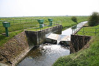
A stream gauge, streamgage or gauging station is a location used by hydrologists or environmental scientists to monitor and test terrestrial bodies of water. Hydrometric measurements of water level surface elevation ("stage") and/or volumetric discharge (flow) are generally taken and observations of biota and water quality may also be made. The location of gauging stations are often found on topographical maps. Some gauging stations are highly automated and may include telemetry capability transmitted to a central data logging facility.

Related Research Articles

Cobb County, Georgia County in the United States

Cobb County is a suburban county in the U.S. state of Georgia. As of 2017, the population was 755,754, making it Georgia's third most-populous county. Its county seat and largest city is Marietta.

Chattahoochee River River in Florida, United States

The Chattahoochee River forms the southern half of the Alabama and Georgia border, as well as a portion of the Florida - Georgia border. It is a tributary of the Apalachicola River, a relatively short river formed by the confluence of the Chattahoochee and Flint rivers and emptying from Florida into Apalachicola Bay in the Gulf of Mexico. The Chattahoochee River is about 430 miles (690 km) long. The Chattahoochee, Flint, and Apalachicola rivers together make up the Apalachicola–Chattahoochee–Flint River Basin. The Chattahoochee makes up the largest part of the ACF's drainage basin.

The Georgia Northeastern Railroad is a short line freight railroad which runs from the town of Elizabeth, Georgia to the city of Blue Ridge, Georgia. Goods hauled are mostly timber, grain, poultry, and marble products. The GNRR's subsidiary, the Blue Ridge Scenic Railway, also operates on this line north of Blue Ridge. Despite the name, it actually operates between north-central and northwest Georgia, from north-northwest metro Atlanta, and is a few counties away from northeast Georgia.

Etowah River river in Georgia

The Etowah River is a 164-mile-long (264 km) waterway that rises northwest of Dahlonega, Georgia, north of Atlanta. On Matthew Carey's 1795 map the river was labeled "High Town River". On later maps, such as the 1839 Cass County map, it was referred to as "Hightower River", a name that was used in most early Cherokee records.

Ernest W. Barrett American politician

Ernest W. Barrett was the chairman of the county commission in Cobb County, Georgia from 1965 to 1984. Barrett was also a former trustee of Kennesaw State University.

Noonday Creek

Noonday Creek is a 20.2-mile-long (32.5 km) stream in Cobb and Cherokee counties in the U.S. state of Georgia. The stream begins near Kennesaw Mountain and ends at Lake Allatoona.

Lake Allatoona

Lake Allatoona is a U.S. Army Corps of Engineers reservoir on the Etowah River in northwestern part of the State of Georgia, in the countryside. This reservoir is mostly in southeastern Bartow County and southwestern Cherokee County. A small portion is located in Cobb County near Acworth. Cartersville is the nearest city to Allatoona Dam. Also, Red Top Mountain State Park is located on its shores, on the peninsula between the two arms of the lake. Most of the north side of the lake remains protected from land development because of its isolated location, mostly blocked by the lake.

There were several historic mills around the metro Atlanta area, for which many of its current-day roads are still named. Most of the mills date back to the 1820s and 1830s, and were built along the area's many streams. The locations of many of these mills are shown on a map of 1875 showing U. S. military operations around Atlanta in 1864. This map is now located in the U. S. Library of Congress but can be seen on the webpage linked here.

Historic ferries operated on rivers around Atlanta, Georgia area, and became namesakes for numerous current-day roads in north Georgia. Most of the ferries date to the early years of European-American settlement in the 1820s and 1830s, when Cherokee and other Native Americans still occupied part of what became Georgia.

Sope Creek is an 11.6-mile-long (18.7 km) stream located in Cobb County, Georgia, United States. It is a significant tributary of the Chattahoochee River. It was known as Soap Creek during the 19th century. A section of Sope Creek runs through the Chattahoochee River National Recreation Area.

Peachtree Creek

Peachtree Creek is a major stream in Atlanta. It flows for 7.5 miles (12.1 km) almost due west into the Chattahoochee River just south of Vinings.

Ernest W. Barrett Parkway

Ernest W. Barrett Parkway is a major thoroughfare in the northwestern part of the Atlanta metropolitan area, in the north-central part of Cobb County, in the U.S. state of Georgia. It travels from the southeastern edge of Kennesaw to a point north of Marietta, and continues on in both directions under other names. The portion of Barrett Parkway between Interstate 575 (I-575/SR 5) and US 41/SR 3 is designated State Route 5 Connector. The road is named after Ernest W. Barrett, the first chairman of the Cobb County Board of Commissioners in the 1960s, after home rule was enacted under a Georgia State Constitution amendment. The initial portion was constructed through Barrett family land, enabling it to be later sold for major development.

Little River (Etowah River tributary)

The Little River is a 29.3-mile-long (47.2 km) tributary of the Etowah River in the U.S. state of Georgia in the United States.

Effects of Hurricane Dennis in Georgia

The effects of Hurricane Dennis in Georgia included two deaths and $24 million (2005 USD) in damage. On June 29, 2005, a tropical wave emerged off the west coast of Africa. Gradually, the system organized on July 2 and formed a broad low pressure area. The system continued to organize, and it became a tropical depression on July 4. Tracking westward, it became a tropical storm on July 5 and a hurricane on July 7. Dennis rapidly intensified to attain Category 4 status on the Saffir-Simpson Hurricane Scale before making landfall on Cuba. The storm weakened to Category 1 status before re-emerging in the Gulf of Mexico and intensifying. Dennis made landfall on the Florida Panhandle on July 10, then tracked over southeast Alabama.

In the U.S. state of Georgia, the Cobb County Parks, Recreation and Cultural Affairs Department is the unit of Cobb county government which handles county parks, recreation facilities, and cultural affairs programs.

Atlanta metropolitan area Metropolitan area in Georgia, United States

Metro Atlanta, designated by the United States Office of Management and Budget as the Atlanta–Sandy Springs–Roswell, GA Metropolitan Statistical Area, is the most populous metro area in the US state of Georgia and the ninth-largest metropolitan statistical area (MSA) in the United States. Its economic, cultural and demographic center is Atlanta, and has an estimated 2018 population of 5,949,951 according to the U.S. Census Bureau. The metro area forms the core of a broader trading area, the Atlanta–Athens-Clarke–Sandy Springs Combined Statistical Area. The Combined Statistical Area spans up to 39 counties in north Georgia and has an estimated 2017 population of 6,555,956. Atlanta is considered a "beta(+) world city." It is the third largest metropolitan region in the Census Bureau's Southeast region behind Greater Washington and Greater Miami.

2009 Southeastern United States floods

The 2009 Southeastern United States floods were a group of floods that affected several counties throughout northern Georgia, Tennessee, Alabama, Mississippi and Arkansas. The worst flooding occurred across the Atlanta metropolitan area. Continuous rain, spawned by moisture pulled from the Gulf of Mexico, fell faster than the local watersheds could drain the runoff.

Willeo Creek

Willeo Creek is a 6.7-mile-long (10.8 km) stream in the U.S. state of Georgia, and is located in the north-northwestern part of metro Atlanta. It is a significant tributary of the Chattahoochee River, into which it flows at Bull Sluice Lake, just upstream from Morgan Falls Dam and downstream from the Chattahoochee Nature Center. Together, the two streams form nearly all of the county line between Fulton to the east and Cobb to the west.

Noses Creek is a 14.5-mile-long (23.3 km) stream in Cobb County, Georgia, USA. It is a significant tributary of the much larger Sweetwater Creek, in turn part of the Chattahoochee River basin. On topographic maps, it begins between Kennesaw and Marietta and flows generally south-southwesterly to just northwest of Austell. It is named for Chief Noses, a native Cherokee who lived in the area in the early 19th century.

References