Related Research Articles

Newport is a town in and the county seat of Sullivan County, New Hampshire, United States. It is 43 miles (69 km) west-northwest of Concord. The population was 6,507 at the 2010 census. A covered bridge is in the northwest. The area is noted for maple sugar and apple orchards. Prior to county division in 1827, Newport was in Cheshire County.
Sugar Creek or Sugarcreek may refer to:

Mill Creek is a 14.0-mile-long (22.5 km) tributary stream of the South Branch Potomac River, belonging to the Potomac River and Chesapeake Bay watersheds. The stream is located in Hampshire County in West Virginia's Eastern Panhandle. Mill Creek flows into the South Branch west of Romney Bridge near Vanderlip along the Northwestern Turnpike.

Eastman Pond is a 320-acre (1.3 km2) water body located in Sullivan and Grafton counties in western New Hampshire, United States, in the towns of Grantham and Enfield. Water from Eastman Pond flows via Eastman Brook and Stocker Brook to the North Branch of the Sugar River, then the Sugar River, and finally the Connecticut River.

The Gale River is a 13.1-mile (21.1 km) long tributary of the Ammonoosuc River in northwestern New Hampshire in the United States. Via the Ammonoosuc, it is part of the watershed of the Connecticut River, which flows to Long Island Sound.
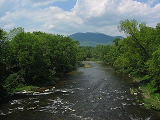
The Sugar River is a 27.0-mile (43.5 km) long river located in western New Hampshire in the United States. It is a tributary of the Connecticut River, which flows to Long Island Sound.

The North Branch of the Sugar River is a 10.1-mile-long (16.3 km) river located in western New Hampshire in the United States. It is a tributary of the Sugar River, which flows to the Connecticut River, which flows to Long Island Sound.
Stocker Brook is a 2.9-mile (4.7 km) long stream located in western New Hampshire in the United States. It is a tributary of the North Branch of the Sugar River, part of the Connecticut River and Long Island Sound drainage basin.

The South Branch of the Sugar River is a 6.6-mile-long (10.6 km) river located in western New Hampshire in the United States. It is a tributary of the Sugar River, which flows to the Connecticut River, which flows to Long Island Sound.

The Coosawattee River is a 49.3-mile-long (79.3 km) river located in the northwestern Georgia, United States.
Sugar Run Creek is a tributary of the Susquehanna River in Bradford County, Pennsylvania, in the United States. It is approximately 7.9 miles (12.7 km) and flows through North Branch Township, Windham Township, and Wilmot Township.

The Johnstone River, comprising the North Johnstone River and the South Johnstone River, is a river system located in Far North and North Queensland, Australia.

The Mackay Railway was a 68 km line situated in the Pioneer River valley in North Queensland, Australia. It opened in a series of sections between 1885 and 1911. 3 short branches junctioned from it, parts of which were initially built by the local government. It closed in sections between 1959 and circa 2007.
References
- ↑ "North Branch Sugar River". Geographic Names Information System . United States Geological Survey . Retrieved 2017-10-04.
| This article related to a river in New York is a stub. You can help Wikipedia by expanding it. |