North Carolina Highway 81

Last updated

NC 81.svg

North Carolina Highway 81
Swannanoa River Road
NC 81 map.svg
Route information
Maintained by NCDOT
Length 4.200 mi [1] (6.759 km)
Existed 1934 – present
Major junctions
West endUS 25.svg US 25 in Asheville
 
East endUS 70.svg US 70 in Asheville
Location
Counties Buncombe
Highway system
NC 80.svg NC 80 NC 82 NC 82.svg

North Carolina Highway 81 (NC 81) is a primary state highway in the U.S. state of North Carolina. That runs entirely in Asheville and Buncombe County from US 25 to US 70.

A state highway, state road, or state route is usually a road that is either numbered or maintained by a sub-national state or province. A road numbered by a state or province falls below numbered national highways in the hierarchy. Roads maintained by a state or province include both nationally numbered highways and un-numbered state highways. Depending on the state, "state highway" may be used for one meaning and "state road" or "state route" for the other.

North Carolina State of the United States of America

North Carolina is a state in the southeastern region of the United States. It borders South Carolina and Georgia to the south, Tennessee to the west, Virginia to the north, and the Atlantic Ocean to the east. North Carolina is the 28th-most extensive and the 9th-most populous of the U.S. states. The state is divided into 100 counties. The capital is Raleigh, which along with Durham and Chapel Hill is home to the largest research park in the United States. The most populous municipality is Charlotte, which is the second-largest banking center in the United States after New York City.

Asheville, North Carolina City in North Carolina, United States

Asheville is a city and the county seat of Buncombe County, North Carolina, United States. It is the largest city in Western North Carolina, and the 12th-most populous city in the U.S. state of North Carolina. The city's population was 89,121 according to 2016 estimates. It is the principal city in the five-county Asheville metropolitan area, with a population of 424,858 in 2010.

Contents

Route Description

Biltmore at Swannanoa NC81-Swannanoa River.jpg
Biltmore at Swannanoa

NC 81 begins at the intersection of All Souls Crescent (US 25 north), Hendersonville Road (US 25 south), and Vanderbilt Road in Historic Biltmore Village. It runs northward via Hendersonville Road for 0.3 miles (0.48 km), intersecting US 25A (Lodge Street) along the way. Immediately after crossing the Swannanoa River, it turns eastward on Swannanoa River Road, which closely tracks the path of the Swannanoa River. Westbound lanes of NC 81, however, are routed for 0.1 miles (0.16 km) via Bryson Street, which intersects Biltmore Avenue one block north of Swannanoa River Road. After 1.6 miles (2.6 km) NC 81 intersects US 74A (South Tunnel Road) near the Asheville Mall. It runs concurrent with US 74A for 1.2 miles (1.9 km) before US 74A turns southward onto Fairview Road. NC 81 continues to follow the Swannanoa River for another 1.1 miles (1.8 km) and then turns to the northward, ultimately terminating at US 70 (Tunnel Road) in Asheville's Oteen neighborhood. [2]

Biltmore Village

Biltmore Village, formerly Best, is a small village that is now entirely in the city limits of Asheville, North Carolina and near the town of Biltmore Forest. It is adjacent to the main entrance of the Biltmore Estate, built by George W. Vanderbilt, one of the heirs to the Vanderbilt family fortune. Once known as the town of Best, George Vanderbilt created this village as a "company town" for the estate workers. The community was planned and designed to reflect the qualities of an English country village. The village had its own church, which is still in operation today as the Cathedral of All Souls, an Episcopal cathedral. The village also had a hospital, shops, a school, a railroad depot, and other services available. Biltmore Village was incorporated into the City of Asheville in the early 20th century. Biltmore Village is a commercial district that has an eclectic collection of shops, restaurants, and other businesses.

Swannanoa River river in the United States of America

The Swannanoa River flows through the Swannanoa Valley of western North Carolina, and is a major tributary to the French Broad River. It begins at its headwaters in Black Mountain, NC, however, it also has a major tributary near its headwaters: Flat Creek, which begins on the slopes of Mount Mitchell. The Swannanoa River ends when it meets the French Broad at Biltmore Estate in Asheville. The river is 22 miles or 35 kilometers long, and it flows entirely within the geographical boundaries of Buncombe County. It is a valuable resource to the county, providing drinking water to the Asheville metropolitan area, and numerous recreational opportunities. In September 2004, massive rains from the remnants of Hurricane Frances and Hurricane Ivan caused the Swannanoa to flood, causing major damage to the Biltmore Village section of Asheville, and to the other communities that it flows through.

Asheville Mall

Asheville Mall is a regional mall in Asheville, North Carolina. Asheville Mall is located off Interstate 240 in eastern Asheville. It is predominantly a one-story mall. Its anchors are Belk, JCPenney, and two Dillard's locations. It has 132 stores and is the largest mall in Western North Carolina. It also dominates the area's retail.

History

NC 81 was designated in 1934 as a renumbering of NC 10 from US 25 (current Biltmore Avenue) to US 70/US 74 (current US 74A). [3] The road was then extended in 1937 when US 25 was rerouted in Asheville. NC 81 was placed south along Biltmore Avenue to the current end of the road at the intersection of US 25 and US 25A. Then in 1938 the road was extended to its current terminus at US 70. [4]

North Carolina Highway 10 highway in North Carolina

North Carolina Highway 10 (NC 10) is a primary state highway in the U.S. state of North Carolina. Originally established as the state's central highway, from Murphy to Beaufort. Nowadays, it serves to connect the city of Newton with the nearby communities and towns in the foothills region.

U.S. Route 74 (US 74) is an east–west United States highway that runs for 515 miles (829 km) from Chattanooga, Tennessee to Wrightsville Beach, North Carolina. Predominantly in North Carolina, it serves as an important highway from the mountains to the sea, connecting the cities of Asheville, Charlotte and Wilmington.

Major intersections

The entire route is in Asheville, Buncombe County.

mi [2] kmDestinationsNotes
0.00.0US 25.svg US 25 (Hendersonville Road / All Souls Crescent)
0.20.32US 25A.svg US 25A (Lodge Street)
1.93.1US 74A.svg US 74A west (South Tunnel Road)Western end of US 74A concurrency
3.15.0US 74A.svg US 74A east (Fairview Road) Lake Lure, Rutherfordton, Charlotte Eastern end of US 74A concurrency
4.26.8US 70.svg US 70 (Tunnel Road)
1.000 mi = 1.609 km; 1.000 km = 0.621 mi

Related Research Articles

Buncombe County, North Carolina County in the United States

Buncombe County is a county located in the U.S. state of North Carolina. The 2010 census said the population was 238,318. Its county seat is Asheville.

North Carolina Highway 75 highway in North Carolina

North Carolina Highway 75 (NC 75) is a primary state highway in the U.S. state of North Carolina. Its entire length runs through Union County and serves as the primary connector between the towns of Waxhaw, Mineral Springs, and Monroe. The route roughly parallels a CSX railroad line for its entire span.

North Carolina Highway 7 highway in North Carolina

North Carolina Highway 7 (NC 7) is a primary state highway in the U.S. state of North Carolina. Entirely within Gaston County, it connects the towns of Lowell, McAdenville, and Belmont with the city of Gastonia.

North Carolina Highway 9 highway in North Carolina

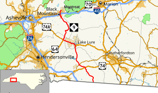
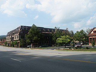
North Carolina Highway 9 (NC 9) is a 46.4-mile (74.7 km) primary state highway in the U.S. state of North Carolina. It serves as a connector route from South Carolina Highway 9 to eastern portions of the Appalachians around Asheville.

North Carolina Highway 97 highway in North Carolina

North Carolina Highway 97 (NC 97) is a primary state highway in the U.S. state of North Carolina, connecting the cities of Zebulon and Rocky Mount with the vast rural coastal plains.

North Carolina Highway 96 highway in North Carolina

North Carolina Highway 96 (NC 96) is a 112-mile-long (180 km) primary state highway in the U.S. state of North Carolina. It is a predominantly rural highway that travels north-south, from NC 55, west of Newton Grove, to the Virginia state line near Virgilina, Virginia, where it continues on as Virginia State Route 96. It also connects the cities of Smithfield, Selma, Zebulon, Youngsville and Oxford.

Interstate 40 (I-40) is a part of the Interstate Highway System that runs from Barstow, California to Wilmington, North Carolina. In North Carolina, I-40 enters the state along the Pigeon River Gorge, from Tennessee. Crossing the entire state, it connects the cities of Asheville, Winston-Salem, Greensboro, Durham and Raleigh before ending along U.S. Highway 117/North Carolina Highway 132 (US 117/NC 132) in Wilmington. The landscapes traversed by I-40 include the Blue Ridge Mountains, foothills of western North Carolina, suburban communities, the urban core of several Piedmont cities, along with eastern North Carolina farmland. At a total of 423.55 miles (681.64 km), it is the longest interstate highway in North Carolina. There are five auxiliary Interstates in the state related to I-40, as well as one business loop which currently runs through Winston-Salem. The route is labeled east-west for the entire route, however the eastern portion follows a much more north-south alignment.

North Carolina Highway 69 highway in North Carolina

North Carolina Highway 69 (NC 69) is a 3.876-mile-long (6.238 km) primary state highway in the U.S. state of North Carolina. It runs north–south from the Georgia state line to Hayesville, west of Chatuge Lake.

North Carolina Highway 68 highway in North Carolina

North Carolina Highway 68 (NC 68) is a north–south state highway in North Carolina. It serves as a connector between Interstate 40 (I-40)/ US 421 and Piedmont Triad International Airport. On its routing from Thomasville to Stokesdale, NC 68 passes through urban High Point, the western outskirts of Greensboro, and the town of Oak Ridge. The segment from just north of the I-40/US 421 interchange to Pleasant Ridge Road in Guilford County is a limited access freeway.

North Carolina Highway 903 highway in North Carolina

North Carolina Highway 903 (NC 903) is a primary state highway in the U.S. state of North Carolina. It serves as predominantly rural highway in the Inner Banks region and arterial road in and around Greenville. The road covers a total of 200 miles (320 km), in a zigzag pattern through the state.

U.S. Route 70 in North Carolina highway in North Carolina

U.S. Route 70 (US 70) is a part of the United States Numbered Highway System that runs from Globe, Arizona, to the Crystal Coast of the US state of North Carolina. In North Carolina, it is a major 488-mile-long (785 km) east–west highway that runs from the Tennessee border to the Atlantic Ocean. From the Tennessee state line near Paint Rock to Asheville it follows the historic Dixie Highway, in concurrency with U.S. Route 25. The highway connects several major cities including Asheville, High Point, Greensboro, Durham, Raleigh, Goldsboro, and New Bern. From Beaufort on east, US 70 shares part of the Outer Banks Scenic Byway, a National Scenic Byway, before ending in the community of Atlantic, located along Core Sound.

North Carolina Highway 280 highway in North Carolina

North Carolina Highway 280 (NC 280) is a primary state highway in the U.S. state of North Carolina that runs from the city of Brevard in Transylvania County to the town of Fletcher in Henderson County. It is 18 miles (29 km) in length, starting at the intersection with US 64 and US 276 north of Brevard to US 25 and US 25A in the Asheville community of Arden.

Interstate 26 (I-26) in North Carolina runs through the Western part of the state, from the Tennessee border to the South Carolina border, following the Appalachian Mountains. It is part of the larger I-26, a regional interstate that runs from Kingsport, Tennessee to in Charleston, South Carolina. I-26 is mostly four lanes through North Carolina with few exceptions. Though nominally an east-west route, in North Carolina and Tennessee, the route goes nearly north-south, with the northern direction labeled "West" and vice versa.

U.S. Route 25 in North Carolina highway in North Carolina

U.S. Route 25 (US 25) is a north–south United States highway that runs for 75.4 miles (121.3 km) from the South Carolina state line, near Tuxedo, to the Tennessee state line, near Hot Springs.

U.S. Route 76 in North Carolina highway in North Carolina

U.S. Highway 76 (US 76) is an east–west road in North Carolina running from the South Carolina state line to Wrightsville Beach. US 76 runs concurrently with US 74 for 52 miles (84 km) of the entire route in North Carolina. US 76 was first designated in North Carolina between late 1934 and 1935.

North Carolina Highway 191 highway in North Carolina

North Carolina Highway 191 (NC 191) is a primary state highway in the U.S. state of North Carolina. It travels within portions of Henderson and Buncombe Counties.

North Carolina Highway 146 highway in North Carolina

North Carolina Highway 146 (NC 146) is a short east/west state highway in western North Carolina and lies entirely in Buncombe County, south of downtown Asheville.

North Carolina Highway 112 highway in North Carolina

North Carolina Highway 112 is an east-west state highway in western North Carolina in Buncombe County, southwest of downtown Asheville.

North Carolina Highway 209 highway in North Carolina

North Carolina Highway 209 (NC 209) is a primary state highway in the U.S. state of North Carolina. The highway runs north–south from Lake Junaluska to Hot Springs.

North Carolina Highway 72 highway in North Carolina

North Carolina Highway 72 (NC 72) is a primary state highway in the U.S. state of North Carolina that serves the communities of Red Springs and Lumberton. The east–west-signed highway physically runs more north and south through Robeson County.

References

  1. "NCDOT GIS Data Layers". North Carolina Department of Transportation. 2012. Retrieved December 28, 2012.
  2. 1 2 Google (December 28, 2012). "North Carolina Highway 81" (Map). Google Maps . Google. Retrieved December 28, 2012.
  3. North Carolina County Road Survey 1936 (PDF) (Map). Cartography by NCSHC / NCSTC / U.S. Bureau of Public Roads. North Carolina State Tax Commission. 1936. Retrieved March 19, 2016.
  4. North Carolina Primary Highway System (PDF) (Map). Cartography by NCDOT. North Carolina Department of Transportation. 1940. Retrieved March 19, 2016.

Route map: Google

KML file (edithelp)
KML is from Wikidata