North Fork Smith River (California)

Last updated
North Fork Smith River
Country United States
States Oregon, California
County Curry County, Oregon, Del Norte County, California
Source Klamath Mountains
 - location Chetco Peak, Kalmiopsis Wilderness, Curry County , Oregon
 - elevation 3,879 ft (1,182 m) [1]
 - coordinates 42°08′16″N123°56′49″W / 42.13778°N 123.94694°W / 42.13778; -123.94694   [2]
Mouth Smith River
 - location Gasquet, Del Norte County , California
 - elevation 315 ft (96 m) [2]
 - coordinates 41°50′52″N123°58′08″W / 41.84778°N 123.96889°W / 41.84778; -123.96889 Coordinates: 41°50′52″N123°58′08″W / 41.84778°N 123.96889°W / 41.84778; -123.96889   [2]
Length 28 mi (45 km) [3]
Basin 158 sq mi (409 km2) [3]
Discharge
 - average 942 cu ft/s (27 m3/s) [3]
Relief map of California.png
Red pog.svg
Location of the mouth of the North Fork Smith River in California
Type Wild, Scenic
Designated October 28, 1988

The North Fork Smith River is 28-mile (45 km) tributary of the Smith River that begins in the U.S. state of Oregon and ends in the U.S. state of California. Arising near Chetco Peak in the Klamath Mountains, it flows generally south to meet the Middle Fork Smith River at Gasquet, California. The combined streams form the Smith River. [4]

Smith River (California) river in northern California, United States

The Smith River is a river flowing from the Klamath Mountains to the Pacific Ocean in Del Norte County in extreme northwestern California, on the West Coast of the United States. It is about 25.1 miles (40.4 km) long, all within Del Norte County, and it flows through the Rogue River – Siskiyou National Forest, Six Rivers National Forest, and Jedediah Smith Redwoods State Park.

U.S. state constituent political entity of the United States

In the United States, a state is a constituent political entity, of which there are currently 50. Bound together in a political union, each state holds governmental jurisdiction over a separate and defined geographic territory and shares its sovereignty with the federal government. Due to this shared sovereignty, Americans are citizens both of the federal republic and of the state in which they reside. State citizenship and residency are flexible, and no government approval is required to move between states, except for persons restricted by certain types of court orders. Four states use the term commonwealth rather than state in their full official names.

Oregon State of the United States of America

Oregon is a state in the Pacific Northwest region on the West Coast of the United States. The Columbia River delineates much of Oregon's northern boundary with Washington, while the Snake River delineates much of its eastern boundary with Idaho. The parallel 42° north delineates the southern boundary with California and Nevada. Oregon is one of only three states of the contiguous United States to have a coastline on the Pacific Ocean.

Contents

Wild and scenic

The entire 13 miles (21 km) of the river that lie within Oregon are part of the National Wild and Scenic Rivers System. In 1988, 8.5 miles (13.7 km) was designated "wild" in two separate segments, from the headwaters to Horse Creek and from Baldface Creek to the Oregon–California border. The 4.5-mile (7.2 km) stretch between Horse and Baldface creeks was classified "scenic". [5]

National Wild and Scenic Rivers System geographical object

The National Wild and Scenic Rivers System was created by the Wild and Scenic Rivers Actof 1968, enacted by the U.S. Congress to preserve certain rivers with outstanding natural, cultural, and recreational values in a free-flowing condition for the enjoyment of present and future generations.

Recreation

Hiking trails near the North Fork include North Fork Trail, which follows a ridge along the southeast edge of the Kalmiopsis Wilderness in the Rogue River – Siskiyou National Forest in Oregon. Suitable for hikers and horseback riders, the 12.4-mile (20.0 km) trail passes through the area of the Biscuit Fire. [6]

Biscuit Fire

The Biscuit Fire was a massive wildfire in 2002 that burned nearly 500,000 acres in the Rogue River–Siskiyou National Forest, in southern Oregon and northern California, in the Western United States. The fire was named after Biscuit Creek in southern Oregon. The Biscuit Fire was the largest wildfire in the recorded history of Oregon. The Biscuit Fire area is subject to warm, dry winds known as the Brookings effect, driven by high pressure over the Great Basin. The fire re-burned portions of the 1987 Silver Fire and subsequently burned in the 2017 Chetco Bar Fire.

Connected to the North Fork Trail is the Baldface Trail, which crosses Baldface Creek, a North Fork tributary. The 6.8-mile (10.9 km) trail, which also passes through the Biscuit Fire area, is suitable for day hiking but not for horse riding. [7]

The North Fork Trail also connects to the Kalmiopsis Rim Trail, which links to a large network of trails in and near the wilderness and other parts of the national forest. The Rim Trail alone is 28.4 miles (45.7 km) long. [8]

Sourdough Campground, undeveloped but open to dispersed camping in a meadow along the river, lies near the confluence of the North Fork with Baldface Creek in Oregon. [5] Further downstream, North Fork Campground is about 0.25 miles (0.40 km) from the lower river on the California side of the border in Six Rivers National Forest. The remote campground, open all year, has five sites for tent or trailer camping, picnic tables, fire rings, a vault toilet, and limited parking, but no drinking water or garbage pickup. [9]

Six Rivers National Forest national forest in the United States

Six Rivers National Forest is a U.S. National Forest located in the northwestern corner of California. It was established on June 3, 1947 by U.S. President Harry S. Truman from portions of Klamath, Siskiyou and Trinity National Forests. Its over one million acres (4,000 km2) of land contain a variety of ecosystems and 137,000 acres (550 km2) of old growth forest. It lies in parts of four counties; in descending order of forestland area they are Del Norte, Humboldt, Trinity, and Siskiyou counties. The forest is named after the Eel, Van Duzen, Klamath, Trinity, Mad, and Smith rivers, which pass through or near the forest's boundaries.

Lightly used by whitewater enthusiasts because it is difficult, remote, and often of insufficient flow for boating, the river is sometimes run for its lower 13 miles (21 km) in rafts or kayaks. This segment, all within California, is rated Class III (intermediate) and IV (advanced) on the International Scale of River Difficulty. [3]

Water quality

The North Fork's water is of outstanding quality, with low turbidity and almost no pollution. [5] Little logging or road building has occurred in its watershed, [3] and silting after storms is not a problem. [5] However, a proposed nickel mine along Baldface Creek threatens to pollute the river and damage its anadromous fish habitat as well as that of the main stem Smith River. [3] In 2012, the Red Flat Nickel Corporation asked permission from the United States Forest Service to allow exploratory mining along the creek. [10] Many local, state, and tribal agencies as well as environmental, fishing, and recreational organizations strongly oppose mining in the watershed. [11]

Tributaries

Named tributaries of the North Fork Smith River from source to mouth are Horse, Chrome, and Hardrock creeks. Then comes Packsaddle Gulch, Baldface, Fall, and Cedar creeks, followed by Diamond, Still, and Stony creeks. [4]

See also

Related Research Articles

Clackamas River tributary of the Willamette River in Oregon

The Clackamas River is an approximately 83-mile (134 km) tributary of the Willamette River in northwestern Oregon, in the United States. Draining an area of about 940 square miles (2,435 km2), the Clackamas flows through mostly forested and rugged mountainous terrain in its upper reaches, and passes agricultural and urban areas in its lower third. The river rises in eastern Marion County, about 55 miles (89 km) east-southeast of Salem. The headwaters are on the slopes of Olallie Butte in the Mount Hood National Forest, about 10 miles (16 km) north of Mount Jefferson, at an elevation of 4,909 feet (1,496 m) in the Cascade Range. The Clackamas flows briefly north and then flows northwest through the mountains, passing through North Fork Reservoir and Estacada. It then emerges from the mountains southeast of Portland. It joins the Willamette near Oregon City and forms the boundary between Oregon City and Gladstone.

American Discovery Trail long-distance hiking and biking trail across the United States

The American Discovery Trail is a system of recreational trails and roads which collectively form a coast-to-coast hiking and biking trail across the mid-tier of the United States. Horses can also be ridden on most of this trail. It starts on the Delmarva Peninsula on the Atlantic Ocean and ends on the northern California coast on the Pacific Ocean. The trail has northern and southern alternates for part of its distance, passing through Chicago and St Louis respectively. The total length of the trail including both the north and south routes is 6,800 miles (10,900 km). The northern route covers 4,834 miles (7,780 km) with the southern route covering 5,057 miles (8,138 km). It is the only non-motorized coast-to-coast trail.

Chetco River river in the United States of America

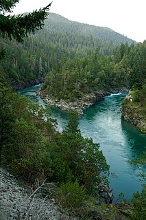
The Chetco River is a 56-mile-long (90 km) stream located in the southwestern portion of the U.S. state of Oregon. It drains approximately 352 square miles (912 km2) of Curry County. Flowing through a rugged and isolated coastal region, it descends rapidly from about 3,200 feet (975 m) to sea level at the Pacific Ocean. Except for the lowermost 5 miles (8 km), the river is located entirely within the Rogue River – Siskiyou National Forest. The river rises in the Kalmiopsis Wilderness, northwest of Chetco Peak at the junction of the Oregon Coast Range and the Klamath Mountains. It flows generally north, west, and then southwest, before emptying into the ocean between Brookings and Harbor, approximately 6 miles (10 km) north of the California state line. The Chetco River's watershed remains largely undeveloped, protected by the Rogue River – Siskiyou National Forest and the Kalmiopsis Wilderness. The upper 45 miles (72 km) of the river have been designated Wild and Scenic since 1988.

Illinois River (Oregon) Oregon tributary of the Rogue River

The Illinois River is a tributary, about 56 miles (90 km) long, of the Rogue River in the U.S. state of Oregon. It drains part of the Klamath Mountains in northern California and southwestern Oregon. The river's main stem begins at the confluence of its east and west forks near Cave Junction in southern Josephine County. Its drainage basin includes Sucker Creek, which rises in the Red Buttes Wilderness, near Whiskey Peak on the California state line. The main stem flows generally northwest in a winding course past Kerby and through the Siskiyou National Forest and Kalmiopsis Wilderness. It joins the Rogue River from the south at Agness on the Curry–Josephine county line, 27 miles (43 km) from the Pacific Ocean.

Elk River (Oregon) river in southwestern Oregon in the United States

The Elk River is in southwestern Oregon in the United States. About 29 miles (47 km) long, the river drains a remote 92-square-mile (240 km2) area of the Coast Range into the Pacific Ocean.

Hells Canyon Wilderness (Oregon and Idaho)

The Hells Canyon Wilderness is a wilderness area in the western United States, in Idaho and Oregon. Created 44 years ago in 1975, the Wilderness is managed by both the U.S. Bureau of Land Management and the U.S. Forest Service and contains some of the most spectacular sections of the Snake River as it winds its way through Hells Canyon, North America's deepest river gorge and one of the deepest gorges on Earth. The Oregon Wilderness Act of 1984 added additional acreage and currently the area protects a total area of 217,927 acres (88,192 ha). It lies entirely within the Hells Canyon National Recreation Area except for a small 946-acre (383 ha) plot in southeastern Wallowa County, Oregon which is administered by the Bureau of Land Management. The area that is administered by the Forest Service consists of portions of the Wallowa, Nez Perce, Payette, and Whitman National Forests.

Smith River National Recreation Area

Smith River National Recreation Area is located northwestern California, United States. The Smith River National Recreation Area is in Six Rivers National Forest and is managed by the U.S. Forest Service, an agency of the U.S. Department of Agriculture. Created by Congress in 1990, Smith River National Recreation Area forms a northern border to Redwood National and State Parks.

Salmon River (Clackamas County, Oregon) river in Oregons Cascade Range

The Salmon River is a 33.5-mile (53.9 km) river in the Cascade Range in the U.S. state of Oregon that drains part of southwestern Mount Hood. The entire length of the river is a protected National Wild and Scenic River. Several portions are in protected wilderness. It is affluent to the Sandy River, a tributary of the Columbia River.

North Fork John Day Wilderness

The North Fork John Day Wilderness is a wilderness area within the Umatilla and Wallowa–Whitman National Forests in the Blue Mountains of northeastern Oregon.

Crooked River (Oregon) tributary of the Deschutes River in the U.S. state of Oregon

The Crooked River is a tributary, 125 miles (201 km) long, of the Deschutes River in the U.S. state of Oregon. The river begins at the confluence of the South Fork Crooked River and Beaver Creek. Of the two tributaries, the South Fork Crooked River is the larger and is sometimes considered part of the Crooked River proper. A variant name of the South Fork Crooked River is simply "Crooked River". The Deschutes River flows north into the Columbia River.

Kalmiopsis Wilderness

Kalmiopsis Wilderness is a wilderness area in the Klamath Mountains of southwestern Oregon, within the Rogue River – Siskiyou National Forest. It was designated wilderness by the United States Congress in 1964 and now comprises a total of 179,755 acres (72,744 ha). There are approximately 153 miles (246 km) of trails on 24 established hiking trails in the area.

South Fork Rogue River tributary of the Rogue River in Oregon

The South Fork Rogue River is a 25-mile (40 km) tributary of the Rogue River in the U.S. state of Oregon. Rising in the Sky Lakes Wilderness in the Cascade Range, it flows generally northeast through the Rogue River – Siskiyou National Forest to meet the Rogue River downstream of Prospect and slightly upstream of Lost Creek Lake.

North Fork Malheur River river in the United States of America

The North Fork Malheur River is a 59-mile (95 km) tributary of the Malheur River in eastern Oregon in the United States. Rising in Big Cow Burn in the Blue Mountains, it flows generally south to join the larger river at Juntura. The upper 25.5 miles (41.0 km) of the river have been designated Wild and Scenic. This part of the river basin offers camping, hiking, and fishing opportunities in a remote forest setting. The lower river passes through Beulah Reservoir, which stores water for irrigation and has facilities for boaters.

Little North Santiam River river in the United States of America

The Little North Santiam River is a 27-mile (43 km) tributary of the North Santiam River in western Oregon in the United States. It drains 113 square miles (290 km2) of the Cascade Range on the eastern side of the Willamette Valley east of Salem.

Roaring River (Clackamas River tributary)

Roaring River is a 13.7-mile (22.0 km) tributary of the Clackamas River in Clackamas County, Oregon. Beginning near Signal Buttes on the western flank of the Cascade Range, the river flows generally west through parts of Mount Hood National Forest to meet the larger river 44 miles (71 km) from its mouth on the Willamette River.

North Fork Owyhee River river in the United States of America

The North Fork Owyhee River is a tributary, about 30 miles (48 km) long, of the Owyhee River in Malheur County, Oregon, and Owyhee County, Idaho, in the United States. It begins on the east flank of the Owyhee Mountains in Idaho and flows generally southwest to meet the main stem at Three Forks, Oregon, 161 miles (259 km) above the confluence of the larger river with the Snake River.

South Fork Burnt River river in the United States of America

The South Fork Burnt River is a tributary of the Burnt River in Baker County in the U.S. state of Oregon. Its headwaters lie in the Monument Rock Wilderness and the Wallowa–Whitman National Forest of the Blue Mountains. It flows generally northeast for about to meet the main stem at Unity Reservoir, north of Unity. The river, about 12 miles (19 km) long, crosses under U.S. Route 26 about 3 miles (5 km) northwest of Unity.

North Fork Umatilla River river in the United States of America

The North Fork Umatilla River is a tributary of the Umatilla River in Union and Umatilla counties in the U.S. state of Oregon. Its headwaters lie in the Umatilla National Forest in the Blue Mountains of northeastern Oregon. It flows generally northwest to meet the South Fork Umatilla River near Graves Butte. Together the two forks form the main stem Umatilla.

Eagle Creek (Powder River)

Eagle Creek is a tributary, 41 miles (66 km) long, of the Powder River in the northeastern part of the U.S. state of Oregon. Beginning at Eagle Lake in the Wallowa Mountains, the creek flows generally southwest and then southeast to meet the river near the small city of Richland. The creek's headwaters are in the Eagle Cap Wilderness within the Wallowa–Whitman National Forest. The upper 28.9 miles (46.5 km) of the creek, from Eagle Lake to the national forest boundary at Skull Creek, are part of the National Wild and Scenic Rivers System.

Matilija Wilderness 29,207-acres of Los Padres National Forest in Southern California

The Matilija Wilderness is a 29,207-acre (11,820 ha) wilderness area in Ventura and Santa Barbara Counties, Southern California. It is managed by the U.S. Forest Service, being situated within the Ojai Ranger District of the Los Padres National Forest. It is located adjacent to the Dick Smith Wilderness to the northwest and the Sespe Wilderness to the northeast, although it is much smaller than either one. The Matilija Wilderness was established in 1992 in part to protect California condor habitat.

References

  1. Source elevation derived from Google Earth search using GNIS source coordinates.
  2. 1 2 3 "North Fork Smith River". Geographic Names Information System (GNIS). United States Geological Survey. January 19, 1981. Retrieved December 30, 2015.
  3. 1 2 3 4 5 6 Palmer, Tim (2014). Field Guide to Oregon Rivers. Corvallis: Oregon State University Press. pp. 123–24. ISBN   978-0-87071-627-0.
  4. 1 2 "United States Topographic Map". United States Geological Survey. Retrieved December 30, 2015 via Acme Mapper.
  5. 1 2 3 4 "Smith River (North Fork), Oregon". National Wild and Scenic Rivers System. Retrieved December 30, 2015.
  6. "North Fork Trail #1233". United States Forest Service. Retrieved December 31, 2015.
  7. "Baldface Trail #1215". United States Forest Service. Retrieved December 31, 2015.
  8. "Kalmiopsis Rim Trail #1124". United States Forest Service. Retrieved December 31, 2015.
  9. "North Fork Campground". United States Forest Service. Retrieved December 30, 2015.
  10. Associated Press (May 4, 2014). "Nickel Mining Company May Mine Oregon Creek That Feeds Scenic California River". The Oregonian. Retrieved December 31, 2015.
  11. Moriarty, Liam (July 16, 2014). "Oregon Nickel Mining Proposal Runs Into Stiff Opposition". Oregon Public Broadcasting. Retrieved December 31, 2015.